Difference between revisions of "2024-08-02 -35 149"
(Created page with "{{subst:Expedition}}") |
m (Location) |
||
| (One intermediate revision by one other user not shown) | |||
| Line 9: | Line 9: | ||
-->{{meetup graticule|date=2024-08-02|lat=-35|lon=149}} | -->{{meetup graticule|date=2024-08-02|lat=-35|lon=149}} | ||
== Location == | == Location == | ||
| − | + | On a street(sign) in Bungendore, New South Wales | |
== Participants == | == Participants == | ||
| − | + | * [[User:Pwc|Patrick]] | |
| − | - | + | * Liz - first geohash |
== Plans == | == Plans == | ||
| − | + | I (Patrick) planned to visit Canberra to see friends and engage in mysterious activities (it is the site of our federal government). Obviously there would be some geohashing — I of course couldn’t know where in advance, and accordingly didn’t advise anyone of those plans. | |
== Expedition == | == Expedition == | ||
| − | + | I booked my flight a genteel week and a half in advance. In anticipation of the geohashing, I spent a few minutes examining the locations of Canberra breweries, but mostly kept my own counsel and did the normal things that I do. | |
| − | + | I decided to fly with Rex (née Regional Express), an airline I’ve never flown before. Technically this was $8 more expensive than flying with Jetstar, but that doesn’t seem like much money (I would simply forgo an airport coffee), and it’s always good to fly with new airlines. | |
| − | + | ||
| + | As a consequence of this decision, Rex [https://www.abc.net.au/news/2024-07-30/rex-airlines-enters-voluntary-administration/104155898 entered voluntary administration] and ceased flying its jet-operated routes. Oops. | ||
| + | |||
| + | Having caused one airline collapse in service of geohashing, I considered my position. Perhaps I could just geohash in Melbourne, like normal people. Perhaps I could drive to Canberra. But I decided to go for the big score, and called up the Evil Villain Airline Qantas, who very generously rebooked me on virtually-identical flights without requesting any money. | ||
| + | |||
| + | I arrived at the airport (attempting to check-in online provoked ominous “Error - Check-in at airport” messages) and... everything ran smoothly. I passed tantalisingly close to the -36 147 hashpoint but otherwise the flight was uneventful. | ||
| + | |||
| + | Liz very kindly picked me up from the airport, and I got in the car and ignored her for 15 minutes while having a complicated arguement-discussion phone conversation with my housemate. I got off the phone and said “Hello! Would you like to do a geohash? We just need to go to Boon-jenn-doree.” (This is not how it’s pronounced.) | ||
| + | |||
| + | She agreed this was a sensible use of time, and we were soon on the open road, with me explaining the details and lore of geohashing. We crossed the territorial border into New South Wales and searched up the hashpoint, which I had surveyed was on or very close to a road in a small residential neighbourhood. As we entered the neighbourhood, there were some twisty turns, and a car behind us followed us for a little while. Liz asked: “Do you think they might also be geohashing?” and I had to admit the sport is not that popular. I am also instructed that I must stop referring to it as a “sport”. | ||
| + | |||
| + | We soon found the hashpoint. My phone took a while to get a sensible reading, so we did a lot of random wandering on the quiet residential street, but in the end holding it above the end-of-road curve marker sign got an acceptable reading. | ||
| + | |||
| + | The drive back to Canberra was uneventful so we celebrated with steak. Hash success. | ||
== Photos == | == Photos == | ||
| − | < | + | <gallery perrow="4"> |
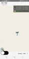
| − | Image:2024- | + | Image:2024-08-02 -35 149 flight cancelled.jpg|The first sign of trouble|alt=A screenshot of two text messages, each saying my flight is cancelled |
| − | -- | + | Image:2024-08-02 -35 149 proof.jpg|Proof|alt=A screenshot showing me 0.671m from the hash |
| − | + | Image:2024-08-02 -35 149 grin.jpeg|Us at the hash|alt=A picture of Patrick and Liz, both smiling | |
| + | Image:2024-08-02 -35 149 the sign.jpeg|The sign on which the has was located|alt=A photo of a “end of road curve” marker roadsign | ||
</gallery> | </gallery> | ||
| Line 36: | Line 50: | ||
__NOTOC__ | __NOTOC__ | ||
| − | |||
| − | |||
| − | |||
| − | |||
| − | |||
| − | |||
| − | |||
| − | |||
| − | |||
| − | |||
[[Category:Expeditions]] | [[Category:Expeditions]] | ||
| − | |||
[[Category:Expeditions with photos]] | [[Category:Expeditions with photos]] | ||
| − | |||
| − | |||
| − | |||
| − | |||
[[Category:Coordinates reached]] | [[Category:Coordinates reached]] | ||
| − | + | {{location|AU|NSW|QB}} | |
| − | |||
| − | |||
| − | |||
| − | |||
| − | |||
| − | |||
| − | |||
| − | |||
| − | |||
| − | |||
| − | |||
| − | |||
| − | |||
Latest revision as of 14:42, 2 August 2024
| Fri 2 Aug 2024 in -35,149: -35.2432433, 149.4484304 geohashing.info google osm bing/os kml crox |
Location
On a street(sign) in Bungendore, New South Wales
Participants
- Patrick
- Liz - first geohash
Plans
I (Patrick) planned to visit Canberra to see friends and engage in mysterious activities (it is the site of our federal government). Obviously there would be some geohashing — I of course couldn’t know where in advance, and accordingly didn’t advise anyone of those plans.
Expedition
I booked my flight a genteel week and a half in advance. In anticipation of the geohashing, I spent a few minutes examining the locations of Canberra breweries, but mostly kept my own counsel and did the normal things that I do.
I decided to fly with Rex (née Regional Express), an airline I’ve never flown before. Technically this was $8 more expensive than flying with Jetstar, but that doesn’t seem like much money (I would simply forgo an airport coffee), and it’s always good to fly with new airlines.
As a consequence of this decision, Rex entered voluntary administration and ceased flying its jet-operated routes. Oops.
Having caused one airline collapse in service of geohashing, I considered my position. Perhaps I could just geohash in Melbourne, like normal people. Perhaps I could drive to Canberra. But I decided to go for the big score, and called up the Evil Villain Airline Qantas, who very generously rebooked me on virtually-identical flights without requesting any money.
I arrived at the airport (attempting to check-in online provoked ominous “Error - Check-in at airport” messages) and... everything ran smoothly. I passed tantalisingly close to the -36 147 hashpoint but otherwise the flight was uneventful.
Liz very kindly picked me up from the airport, and I got in the car and ignored her for 15 minutes while having a complicated arguement-discussion phone conversation with my housemate. I got off the phone and said “Hello! Would you like to do a geohash? We just need to go to Boon-jenn-doree.” (This is not how it’s pronounced.)
She agreed this was a sensible use of time, and we were soon on the open road, with me explaining the details and lore of geohashing. We crossed the territorial border into New South Wales and searched up the hashpoint, which I had surveyed was on or very close to a road in a small residential neighbourhood. As we entered the neighbourhood, there were some twisty turns, and a car behind us followed us for a little while. Liz asked: “Do you think they might also be geohashing?” and I had to admit the sport is not that popular. I am also instructed that I must stop referring to it as a “sport”.
We soon found the hashpoint. My phone took a while to get a sensible reading, so we did a lot of random wandering on the quiet residential street, but in the end holding it above the end-of-road curve marker sign got an acceptable reading.
The drive back to Canberra was uneventful so we celebrated with steak. Hash success.
Photos

The first sign of trouble
Proof

Us at the hash
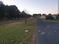
The sign on which the has was located


