Difference between revisions of "2024-07-30 -12 130"
Felix Dance (talk | contribs) ([retro picture]Looking east) |
m (Location) |
||
| (5 intermediate revisions by 2 users not shown) | |||
| Line 1: | Line 1: | ||
| − | + | [[Image:{{{image|2024-07-30_-12_130_Felix Dance _1722416638285.jpg}}}|thumb|left]] | |
| − | + | {{meetup graticule|date=2024-07-30|lat=-12|lon=130}} | |
| − | |||
| − | |||
| − | |||
| − | |||
| − | |||
| − | |||
== Location == | == Location == | ||
| − | + | The centre of the Rapid Creek Picnic Area, Brinkin, Darwin. | |
== Participants == | == Participants == | ||
| − | + | *Tali | |
| − | |||
| − | == | + | == Expedition == |
| − | + | Tali went for a walk after work and reached this geohashing point. It was 6:42pm. | |
| − | + | She was alerted to the hash by [[User:Felix Dance|Felix]]. Felix found out about it because in the geohashing messaging group he saw people asking who knew anyone in the NT who could go and do a hash, so he looked at Darwin, saw this very neat and accessible hash in the middle of a park near where his friend lived, and got contacting. When Tali said she could do it he triumphantly alerted the group that the hash would be achieved. | |
| − | |||
| − | + | He later discovered that everyone was talking about the global hash, hundreds of kilometers to the west of Alice Springs, itself over a thousand kilometers from Darwin. Oh well, an NT hash came out of this situation so it's all good. | |
| − | |||
== Photos == | == Photos == | ||
| − | |||
| − | |||
| − | |||
<gallery perrow="5"> | <gallery perrow="5"> | ||
| Line 40: | Line 28: | ||
== Achievements == | == Achievements == | ||
| − | {{ | + | {{Walk geohash |
| − | + | ||
| + | | latitude = -12 | ||
| + | | longitude = 130 | ||
| + | | date = 2024-07-30 | ||
| + | | name = Tali | ||
| + | | distance = ~2kms | ||
| + | | image = 2024-07-30_-12_130_Felix Dance _1722416638285.jpg | ||
| + | |||
| + | }} | ||
| + | |||
| + | {{Puppet Master Geohash | ||
| − | + | | latitude = -12 | |
| − | + | | longitude = 130 | |
| − | + | | date = 2024-07-30 | |
| − | [[ | + | | puppet = Tali |
| + | | name = [[User:Felix Dance|Felix]] | ||
| + | | image = 2024-07-30_-12_130_Felix Dance _1722416638285.jpg | ||
| − | + | }} | |
| − | |||
| − | |||
| − | |||
| − | + | __NOTOC__ | |
[[Category:Expeditions]] | [[Category:Expeditions]] | ||
| − | |||
[[Category:Expeditions with photos]] | [[Category:Expeditions with photos]] | ||
| − | |||
| − | |||
| − | |||
| − | |||
[[Category:Coordinates reached]] | [[Category:Coordinates reached]] | ||
| − | + | {{location|AU|NT|DR}} | |
| − | |||
| − | |||
| − | |||
| − | |||
| − | |||
| − | |||
| − | |||
| − | |||
| − | |||
| − | |||
| − | |||
| − | |||
| − | |||
Latest revision as of 18:42, 2 August 2024

| Tue 30 Jul 2024 in -12,130: -12.3720911, 130.8623167 geohashing.info google osm bing/os kml crox |
Location
The centre of the Rapid Creek Picnic Area, Brinkin, Darwin.
Participants
- Tali
Expedition
Tali went for a walk after work and reached this geohashing point. It was 6:42pm.
She was alerted to the hash by Felix. Felix found out about it because in the geohashing messaging group he saw people asking who knew anyone in the NT who could go and do a hash, so he looked at Darwin, saw this very neat and accessible hash in the middle of a park near where his friend lived, and got contacting. When Tali said she could do it he triumphantly alerted the group that the hash would be achieved.
He later discovered that everyone was talking about the global hash, hundreds of kilometers to the west of Alice Springs, itself over a thousand kilometers from Darwin. Oh well, an NT hash came out of this situation so it's all good.
Photos
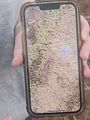
GPS proof
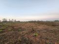
Looking North
Looking west

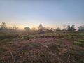
Looking east


Achievements
Tali earned the Walk geohash Achievement
|
Felix earned the Puppet Master Geohash achievement
|