Difference between revisions of "2024-08-16 58 5"
From Geohashing
(→Location) |
(→Expedition) |
||
| (9 intermediate revisions by the same user not shown) | |||
| Line 8: | Line 8: | ||
And DON'T FORGET to add your expedition and the best photo you took to the gallery on the Main Page! We'd love to read your report, but that means we first have to discover it! :) | And DON'T FORGET to add your expedition and the best photo you took to the gallery on the Main Page! We'd love to read your report, but that means we first have to discover it! :) | ||
-->{{meetup graticule|date=2024-08-16|lat=58|lon=5}} | -->{{meetup graticule|date=2024-08-16|lat=58|lon=5}} | ||
| + | |||
| + | [[Image:20240816 58 5 Me.jpg|thumb|left]] | ||
| + | |||
== Location == | == Location == | ||
<!-- where you've surveyed the hash to be --> | <!-- where you've surveyed the hash to be --> | ||
| Line 16: | Line 19: | ||
<!-- who attended: If you link to your wiki user name in this section, your expedition will be picked up by the various statistics generated for geohashing. You may use three tildes ~ as a shortcut to automatically insert the user signature of the account you are editing with. | <!-- who attended: If you link to your wiki user name in this section, your expedition will be picked up by the various statistics generated for geohashing. You may use three tildes ~ as a shortcut to automatically insert the user signature of the account you are editing with. | ||
--> | --> | ||
| + | |||
| + | *[[User:Pica42|Pica42]] | ||
== Plans == | == Plans == | ||
| Line 22: | Line 27: | ||
== Expedition == | == Expedition == | ||
<!-- how it all turned out. your narrative goes here. --> | <!-- how it all turned out. your narrative goes here. --> | ||
| + | |||
| + | This was a nice trip among cows and sheep. The hash point was in a grazing area and was easy to get to. | ||
== Tracklog == | == Tracklog == | ||
| Line 33: | Line 40: | ||
Image:2024-08-16_58_5_Pica42_1723801335416.jpg|Sviland [https://openstreetmap.org/?mlat=58.82838110&mlon=5.80412940&zoom=16 @58.8284,5.8041] | Image:2024-08-16_58_5_Pica42_1723801335416.jpg|Sviland [https://openstreetmap.org/?mlat=58.82838110&mlon=5.80412940&zoom=16 @58.8284,5.8041] | ||
| − | + | Image:20240816 58 5 N.jpg|thumb|View to the north | |
| + | Image:20240816 58 5 W.jpg|thumb|View to the west | ||
| + | Image:20240816 58 5 S.jpg|thumb|View to the south | ||
| + | Image:20240816 58 5 E.jpg|thumb|View to the east | ||
| + | Image:20240816 58 5 Friends.jpg|thumb|Friends | ||
</gallery> | </gallery> | ||
| Line 40: | Line 51: | ||
<!-- Add any achievement ribbons you earned below, or remove this section --> | <!-- Add any achievement ribbons you earned below, or remove this section --> | ||
| − | + | {{land geohash |name=[[User:Pica42|Pica42]] |date=2024-08-16 |latitude=58 |longitude=5 }} | |
| − | |||
| − | |||
| − | [[ | ||
| − | |||
| − | |||
| − | |||
| − | |||
| − | |||
| − | |||
| − | |||
[[Category:Expeditions]] | [[Category:Expeditions]] | ||
| − | |||
[[Category:Expeditions with photos]] | [[Category:Expeditions with photos]] | ||
| − | |||
| − | |||
| − | |||
| − | |||
[[Category:Coordinates reached]] | [[Category:Coordinates reached]] | ||
| + | {{location|NO|11}} | ||
| − | |||
| − | |||
| − | |||
| − | |||
| − | |||
| − | |||
| − | |||
| − | + | __NOTOC__ | |
| − | |||
| − | |||
| − | |||
Latest revision as of 16:21, 22 August 2024
| Fri 16 Aug 2024 in 58,5: 58.8284010, 5.8041823 geohashing.info google osm bing/os kml crox |

Location
Vindberget, Sviland, Sandnes, Norway
Participants
Plans
Expedition
This was a nice trip among cows and sheep. The hash point was in a grazing area and was easy to get to.
Tracklog
Photos

Sviland @58.8284,5.8041
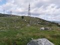
View to the north
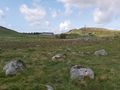
View to the west
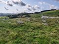
View to the south
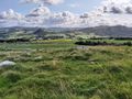
View to the east
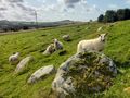
Friends


Achievements
Pica42 earned the Land geohash achievement
|