Difference between revisions of "2024-08-08 51 7"
m (Location) |
(expedition report for Wuppertal) |
||
| (One intermediate revision by one other user not shown) | |||
| Line 1: | Line 1: | ||
| − | |||
| − | |||
| − | |||
| − | |||
| − | |||
| − | |||
{{meetup graticule|date=2024-08-08|lat=51|lon=7}} | {{meetup graticule|date=2024-08-08|lat=51|lon=7}} | ||
== Location == | == Location == | ||
| Line 42: | Line 36: | ||
From the Hauptbahnhof station, we walked a bit in the old town (formerly Elberfeld). By this point I was hungry, and Georg noticed a market in the square, so we ate at a sausage stand there. Georg also introduced me to stolpersteine; I followed him to look for several of these by foot, Schwebebahn, and bus until eventually we returned to the Hauptbahnhof and I decided to depart. | From the Hauptbahnhof station, we walked a bit in the old town (formerly Elberfeld). By this point I was hungry, and Georg noticed a market in the square, so we ate at a sausage stand there. Georg also introduced me to stolpersteine; I followed him to look for several of these by foot, Schwebebahn, and bus until eventually we returned to the Hauptbahnhof and I decided to depart. | ||
| + | |||
| + | === GeorgDerReisende === | ||
| + | |||
| + | Now I don't know, what I have planned. The trains from Kassel to Wuppertal run hourly and with the 7 o'clock train I would have been too early and with the 8 o'clock train I would have been too late. The plan was to change from the train to the Schwebebahn at Oberbarmen and to travel one segment of my journey along the whole track from Oberbarmen to Vohwinkel with the Schwebebahn. Now I found out that I was late, very late, and I cancelled the plan of the whole track and changed for the Schwebebahn at the main station. But with this change there I arrived too late at Vohwinkel. At 11:45. Because I have no internet on my runs I couldn't contact coyotebush and I found me lost. Just for fun I tried a second passage at the hash, taking then some photos and then start a walk for Wuppertal. And I wanted to take a last photo of a Schwebebahn train approaching the station Pestalozzistraße, I waited for the next train, I took the photo, the train stopped, a single man stepped out, he turned around to me and asked: it's you, Georg? We greeted and talked, made the journey to the hash twice again and then traveled to the city for some sightseeing and eating. | ||
| + | |||
| + | But usually I am not sightseeing in the cities, but I take photos for the wikipedia, and in Wuppertal I was only searching for the stolpersteins. I showed one of them to coyotebush and after our meal we went for looking for some of them, but at the first three places we visited, we didn't find some. (For some mistake of mine, I found later out, the visited adresses were wrong in Wuppertal but right in Cologne and at the third place it seems to me, that there never were stolpersteins placed for unknown reasons and all people desribing them copied from the same wrong source.) Later at the fifth place I found some at the Adersstraße. Later I found more. | ||
== Tracklogs == | == Tracklogs == | ||
| Line 48: | Line 48: | ||
{{tracklog|2024-08-08 51 7 coyotebush phone.gpx}} | {{tracklog|2024-08-08 51 7 coyotebush phone.gpx}} | ||
| − | |||
| − | |||
| − | |||
| − | |||
| − | |||
| − | |||
coyotebush's watch: | coyotebush's watch: | ||
| Line 75: | Line 69: | ||
| 12:24 || eastbound || 12m S || 4m S || 1m S | | 12:24 || eastbound || 12m S || 4m S || 1m S | ||
|} | |} | ||
| + | |||
| + | GeorgDerReisende | ||
| + | |||
| + | {{tracklog|2024-08-08 51 7 GeorgDerReisende.gpx}} | ||
== Photos == | == Photos == | ||
=== coyotebush === | === coyotebush === | ||
| − | |||
| − | |||
| − | |||
<gallery perrow="5"> | <gallery perrow="5"> | ||
Latest revision as of 09:06, 8 September 2024
| Thu 8 Aug 2024 in 51,7: 51.2480609, 7.1226031 geohashing.info google osm bing/os kml crox |
Location
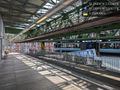
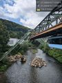
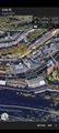
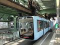
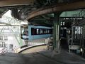
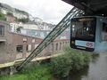
Along the route of the Wuppertal Schwebebahn.
That is, on the Wupper river in Wuppertal. Between the Pestalozzistraße and Westende stations, near a pipeline crossing the river and even closer to a track support.
Google's imagery shows the tracks crossing the point, but it's clearly taken from a southward angle. OSM and Bing imagery show the tracks a few meters south of the point.
shotgun shows only one other point along the Schwebebahn route: 1957-02-13 is only about 150m upstream from this one.
Participants
Plans
coyotebush
I already wanted to visit Wuppertal and ride the Schwebebahn sometime this week. So I'll go do that, ride on the north side, and hope to get close enough.
GeorgDerReisende
I have no internet on the run and cannot communicate though. But I hope I am at the Vohwinkel station at 11:00. On the platform for arriving Schwebebahnen.
- OK, I will try to catch the RB train that arrives shortly after 10:30, then either walk from the Vohwinkel rail station or take Schwebebahn back from the Hbf. But I may be 30 minutes later than that. Coyotebush (talk) 05:55, 8 August 2024 (UTC)
Expedition
coyotebush
- Caught that train, so on track (heh) for 11:00. -- Coyotebush (talk) @50.9583,7.0138 09:59, 8 August 2024 (GMT+02:00)
I walked from Wuppertal-Vohwinkel to the Schwebebahn end station and waited for a while, thinking this would give me the best chance of meeting Georg. I enjoyed seeing the large track switch operate to direct one train into the maintenance facility instead of around the turning loop.
- On the Vohwinkel arrival platform. I see now that westbound Schwebebahnen would use the northern rail, which is closer to the point. -- Coyotebush (talk) @51.2304,7.0680 10:45, 8 August 2024 (GMT+02:00)
- Watched 8 or so trains arrive but unfortunately never spotted Georg. Going to start riding one. -- Coyotebush (talk) @51.2302,7.0679 11:42, 8 August 2024 (GMT+02:00)
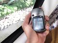
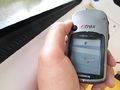
Found a restroom and then a train. I figured I would ride Vohwinkel->Pestalozzistraße->Westende->Pestalozzistraße->Westende->Hauptbahnhof in order to pass the point westbound twice. I started recording a track using the Strava app (in addition to my Garmin watch), which as a bonus maintained a good GPS fix for photo geotagging and Geohash Droid. Then once close, I started a screen recording of Geohash Droid.
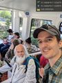
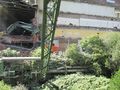
On the first pass, I saw a 4 meter distance displayed, which matches the closest recorded point in the Strava track. The second time I exited at Pestalozzistraße, there was Georg! We chatted briefly and continued with my plan. Didn't get as close a distance on the second westbound pass. We saw some vehicles on treads driving in the shallow river - only in retrospect did I realize that wading to the point might have been an option.
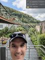
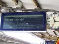
From the Hauptbahnhof station, we walked a bit in the old town (formerly Elberfeld). By this point I was hungry, and Georg noticed a market in the square, so we ate at a sausage stand there. Georg also introduced me to stolpersteine; I followed him to look for several of these by foot, Schwebebahn, and bus until eventually we returned to the Hauptbahnhof and I decided to depart.
GeorgDerReisende
Now I don't know, what I have planned. The trains from Kassel to Wuppertal run hourly and with the 7 o'clock train I would have been too early and with the 8 o'clock train I would have been too late. The plan was to change from the train to the Schwebebahn at Oberbarmen and to travel one segment of my journey along the whole track from Oberbarmen to Vohwinkel with the Schwebebahn. Now I found out that I was late, very late, and I cancelled the plan of the whole track and changed for the Schwebebahn at the main station. But with this change there I arrived too late at Vohwinkel. At 11:45. Because I have no internet on my runs I couldn't contact coyotebush and I found me lost. Just for fun I tried a second passage at the hash, taking then some photos and then start a walk for Wuppertal. And I wanted to take a last photo of a Schwebebahn train approaching the station Pestalozzistraße, I waited for the next train, I took the photo, the train stopped, a single man stepped out, he turned around to me and asked: it's you, Georg? We greeted and talked, made the journey to the hash twice again and then traveled to the city for some sightseeing and eating.
But usually I am not sightseeing in the cities, but I take photos for the wikipedia, and in Wuppertal I was only searching for the stolpersteins. I showed one of them to coyotebush and after our meal we went for looking for some of them, but at the first three places we visited, we didn't find some. (For some mistake of mine, I found later out, the visited adresses were wrong in Wuppertal but right in Cologne and at the third place it seems to me, that there never were stolpersteins placed for unknown reasons and all people desribing them copied from the same wrong source.) Later at the fifth place I found some at the Adersstraße. Later I found more.
Tracklogs
coyotebush's phone:
coyotebush's watch:
Using Viking's ruler tool, it looks like these came close to the hashpoint, especially accepting the watch's questionable accuracy and interpolating straight lines between its every-2-seconds recorded points.
| Time | Traveling | Closest phone | Closest watch | Closest interpolated watch |
|---|---|---|---|---|
| 11:53 | eastbound | 7m N | 22m N | 22m N |
| 12:00 | westbound | 4m N | 8m N | 6m N |
| 12:05 | eastbound | 11m S | 8m N | 3m N |
| 12:12 | westbound | 13m N | 9m S | 1m S |
| 12:24 | eastbound | 12m S | 4m S | 1m S |
GeorgDerReisende
Photos
coyotebush
Georg's stated location @51.2309,7.0698
view west from Pestalozzistraße @51.2485,7.1253
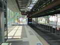
a hasher at Pestalozzistraße @51.2486,7.1252
two hashers departing Pestalozzistraße @51.2484,7.1246
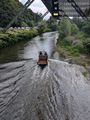
river truck at Westende @51.2489,7.1189
best distance seen
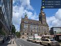
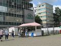
market in front of Rathaus Elberfeld @51.2582,7.1465


GeorgDerReisende
arrived in Wuppertal
first try
look out
this was the first train
this is the second train
second try
look out
a third train
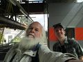
two geohashers
bratwurst stand
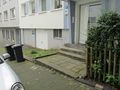
Adersstraße 23
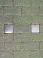
two stolpersteine


Achievements
coyotebush and GeorgDerReisende earned the Meet-up achievement
|
GeorgDerReisende and coyotebush earned the Public transport geohash achievement
|