Difference between revisions of "2024-09-19 54 9"
m (Location correction) |
(Categories) |
||
| Line 83: | Line 83: | ||
}} | }} | ||
| − | |||
| − | |||
[[Category:Expeditions]] | [[Category:Expeditions]] | ||
| − | |||
[[Category:Expeditions with photos]] | [[Category:Expeditions with photos]] | ||
| − | |||
| − | |||
[[Category:Coordinates reached]] | [[Category:Coordinates reached]] | ||
{{location|DE|SH|NMS}} | {{location|DE|SH|NMS}} | ||
Latest revision as of 23:45, 22 September 2024
| Thu 19 Sep 2024 in 54,9: 54.0845834, 9.9511244 geohashing.info google osm bing/os kml crox |
Location
Within the Stadtwald Neumünster, the city forest of Neumünster, Roughly twenty meters from the nearest path.
Participants
Plans
Gaboversta
During the commute to work gaboversta noticed this hash being really close to Neumünster. Upon closer inspection it was found to be within comfortable walking distance of the Neumünster Stadtwald local rail stop. Since travel times from Kiel are short this expedition was scheduled for right after work.
Expedition
Gaboversta
At around 18:00 I departed from Kiel main station, having arrived there from work a few minutes earlier. With a couple minutes of delay the Regional Express train to Hamburg departs and I remember to activate the GPS tracing. This did not work out, my phone decided, that it would only start remembering locations once the precision was satisfactory, which did not happen onboard this train. After the short ride to Neumünster main station I changed onto the Regional Bahn towards Hohenwestedt and got off just three minutes later at Neumünster Stadtwald.
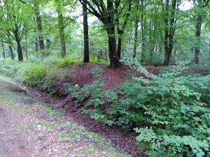
This cozy stop greeted me with the noise of the major road right next to it and some nice, foresty views. Having followed said road for a few meters I crossed over it and continued on into the forest proper. Sticking to the paths parallel to, but not directly on the roads I made quick progress towards the chosen patch of earth. I couldn't help but notice some paved streets were my map just showed a trench. Shortly before reaching the geohash I changed onto one such road and got to see that proper moat with my own eyes. Dense greenery was covering a meter wide and deep ditch (and still is). I needed to get to the other side of that waterless elongated hole and was already considering turning around and trying my luck from the other side, when I reached what might have been the moat's closest point to the geohash. I was presented with a gap in the greenery and a slightly less steep decline into the abyss. This might have been a sign, and so I crossed over.
After crossing over one more recreational path and at almost 19:00, the coordinates were reached and a rather unimpressive picture was taken to commemorate the moment.
On the way back I discovered that the passable bit of the trench didn't look all that passable anymore and decided to cross it anyways. In return, the way back to the station had some nice views of the railway on offer.
Photos
Achievements
gaboversta earned the Easily Publicly Transported Achievement
|


