Difference between revisions of "2024-08-26 49 11"
From Geohashing
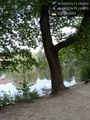
([retro picture]Valzner Weiher [https://openstreetmap.org/?mlat=49.43821670&mlon=11.13589780&zoom=16 @49.4382,11.1359]) |
m (Location) |
||
| (5 intermediate revisions by 2 users not shown) | |||
| Line 1: | Line 1: | ||
| − | + | {{meetup graticule|date=2024-08-26|lat=49|lon=11}} | |
| − | |||
| − | |||
| − | |||
| − | |||
| − | |||
| − | |||
| − | |||
| − | |||
== Location == | == Location == | ||
| − | + | This Geohash is located in a forest outside of Zerzabelshof. | |
== Participants == | == Participants == | ||
| − | + | *[[User:Torodeas|Torodeas]] | |
| − | |||
== Plans == | == Plans == | ||
| Line 31: | Line 22: | ||
Image:2024-08-26_49_11_Torodeas_1724720997449.jpg|Valzner Weiher [https://openstreetmap.org/?mlat=49.43821670&mlon=11.13589780&zoom=16 @49.4382,11.1359] | Image:2024-08-26_49_11_Torodeas_1724720997449.jpg|Valzner Weiher [https://openstreetmap.org/?mlat=49.43821670&mlon=11.13589780&zoom=16 @49.4382,11.1359] | ||
| + | |||
| + | Image:2024-08-26_49_11_Torodeas_1724720997486.jpg|Valzner Weiher bus stop [https://openstreetmap.org/?mlat=49.43807500&mlon=11.13093000&zoom=16 @49.4381,11.1309] | ||
| + | |||
| + | Image:2024-08-26_49_11_Torodeas_1724720997492.jpg|Proof | ||
| + | |||
| + | Image:2024-08-26_49_11_Torodeas_1724720997540.jpg|At the hash | ||
| + | |||
| + | Image:2024-08-26_49_11_Torodeas_1724720997565.jpg|View from hash | ||
</gallery> | </gallery> | ||
| Line 38: | Line 37: | ||
__NOTOC__ | __NOTOC__ | ||
| − | |||
| − | |||
| − | |||
| − | |||
| − | |||
| − | |||
| − | |||
| − | |||
| − | |||
| − | |||
[[Category:Expeditions]] | [[Category:Expeditions]] | ||
| − | |||
[[Category:Expeditions with photos]] | [[Category:Expeditions with photos]] | ||
| − | |||
| − | |||
| − | |||
| − | |||
[[Category:Coordinates reached]] | [[Category:Coordinates reached]] | ||
| − | + | {{location|DE|BY|LAU}} | |
| − | |||
| − | |||
| − | |||
| − | |||
| − | |||
| − | |||
| − | |||
| − | |||
| − | |||
| − | |||
| − | |||
| − | |||
| − | |||
Latest revision as of 20:42, 23 September 2024
| Mon 26 Aug 2024 in 49,11: 49.4370320, 11.1443043 geohashing.info google osm bing/os kml crox |
Location
This Geohash is located in a forest outside of Zerzabelshof.
Participants
Plans
Expedition
Tracklog
Photos
Valzner Weiher @49.4382,11.1359

Valzner Weiher bus stop @49.4381,11.1309

Proof

At the hash

View from hash


