Difference between revisions of "2024-11-01 48 11"
From Geohashing
| (5 intermediate revisions by the same user not shown) | |||
| Line 12: | Line 12: | ||
== Expedition == | == Expedition == | ||
| − | *[[User:Iqui|Iqui]]: Went there by bike and picked up [[ | + | *[[User:Iqui|Iqui]]: Went there by bike and picked up [[1970-07-31 48 11]] and [[2000-01-11 48 11]] along the way. I also finally got to see the [[wikipedia:de:Ismaninger Speichersee|Speichersee]] from the top of the dam on the way back home! |
== Photos == | == Photos == | ||
| Line 28: | Line 28: | ||
== Achievements == | == Achievements == | ||
{{#vardefine:ribbonwidth|100%}} | {{#vardefine:ribbonwidth|100%}} | ||
| + | {{Two to the N achievement | count = 4 | latitude = 48 | longitude = 11 | date = 2024-11-01 | reached = true | name = [[User:Iqui|Iqui]]}} | ||
{{land geohash | latitude = 48 | longitude = 11 | date = 2024-11-01 | name = [[User:Iqui|Iqui]]}} | {{land geohash | latitude = 48 | longitude = 11 | date = 2024-11-01 | name = [[User:Iqui|Iqui]]}} | ||
{{Bicycle geohash | latitude = 48 | longitude = 11 | date = 2024-11-01 | name = [[User:Iqui|Iqui]] | distance = 53,3 km | bothways = true}} | {{Bicycle geohash | latitude = 48 | longitude = 11 | date = 2024-11-01 | name = [[User:Iqui|Iqui]] | distance = 53,3 km | bothways = true}} | ||
Latest revision as of 18:55, 1 November 2024
| Fri 1 Nov 2024 in 48,11: 48.2038019, 11.8009823 geohashing.info google osm bing/os kml crox |
Location
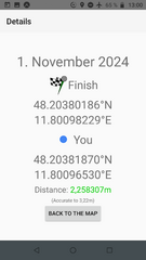
On a meadow in Pliening
Participants
- Iqui
- my mother
Expedition
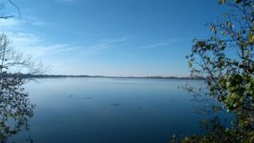
- Iqui: Went there by bike and picked up 1970-07-31 48 11 and 2000-01-11 48 11 along the way. I also finally got to see the Speichersee from the top of the dam on the way back home!
Photos
Tracklog
Achievements
Iqui earned the Two to the N achievement
|
Iqui earned the Land geohash achievement
|
Iqui earned the Bicycle geohash achievement
|


