Difference between revisions of "2025-02-16 58 6"
From Geohashing
(→Achievements) |
(→Expedition) |
||
| (10 intermediate revisions by the same user not shown) | |||
| Line 14: | Line 14: | ||
<!-- where you've surveyed the hash to be --> | <!-- where you've surveyed the hash to be --> | ||
| − | Vølstad in Gjesdal municipality, Norway | + | Vølstad in Gjesdal municipality, Rogaland, Norway |
== Participants == | == Participants == | ||
| Line 27: | Line 27: | ||
== Expedition == | == Expedition == | ||
<!-- how it all turned out. your narrative goes here. --> | <!-- how it all turned out. your narrative goes here. --> | ||
| + | |||
| + | This trip was about 34 km by car and about 300 meters on foot one way to find today's geohashing point. It was a bit cold, about 4 °C but no wind. The last part was in a rock pile. | ||
== Tracklog == | == Tracklog == | ||
| Line 49: | Line 51: | ||
| − | name=[[User:Pica42| | + | {{land geohash |name=[[User:Pica42|pica42]] |date=2025-02-16 |latitude=58 |longitude=6 }} |
[[Category:Expeditions]] | [[Category:Expeditions]] | ||
[[Category:Expeditions with photos]] | [[Category:Expeditions with photos]] | ||
| Line 55: | Line 57: | ||
{{location|NO|11}} | {{location|NO|11}} | ||
| − | Frozen Geohash | + | {{Frozen Geohash | latitude = 58 | longitude = 6 |date=2025-02-16 | name = pica42 | temperature = -3°C}} |
| − | + | ||
| − | |||
| − | |||
| − | | date = | ||
| − | | temperature = | ||
| − | |||
__NOTOC__ | __NOTOC__ | ||
Latest revision as of 16:04, 2 March 2025
| Sun 16 Feb 2025 in 58,6: 58.7891585, 6.0562162 geohashing.info google osm bing/os kml crox |
Location
Vølstad in Gjesdal municipality, Rogaland, Norway
Participants
Plans
Expedition
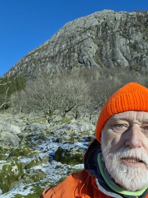
This trip was about 34 km by car and about 300 meters on foot one way to find today's geohashing point. It was a bit cold, about 4 °C but no wind. The last part was in a rock pile.
Tracklog
Photos
Achievements
pica42 earned the Land geohash achievement
|
pica42 earned the Frozen Geohash Achievement
|


