Difference between revisions of "2009-01-31 33 -84"
imported>Woodveil (→Woodveil) |
imported>FippeBot m (Location) |
||
| (9 intermediate revisions by 5 users not shown) | |||
| Line 10: | Line 10: | ||
== About == | == About == | ||
| − | This was an extremely northern set of coordinates, only a matter of feet from the northern edge of the [[Atlanta, Georgia|Atlanta]] graticule. The actual hashpoint was in a very nice man | + | This was an extremely northern set of coordinates, only a matter of feet from the northern edge of the [[Atlanta, Georgia|Atlanta]] graticule. The actual hashpoint was in a front yard, under a tree. We knocked on the front door of the closest house and were greeted by a very nice man, who gave us permission to take pictures in his yard, and also informed us the tree in question was in fact a tulip tree. This expedition was the first official xkcd meetup for the Atlanta graticule. Weather was around 50°F and sunny. |
== Expedition == | == Expedition == | ||
=== [[User:NWoodruff|NWoodruff]] === | === [[User:NWoodruff|NWoodruff]] === | ||
| + | |||
| + | I ended up arriving around 3:45pm as I was a short drive from this location. I am also very familiar with this location as in my ex-wife's parents live within walking distance from this hash only one street over. Having lived in this area since 1976, and having gone to the park at least 5 times a summer since I was in high school, I did not make the excursion to the park after the meet up. I did forget to tell [[User:Woodveil| Woodveil]] that the squirrels do like potato chips and if you sit still enough, the squirrels will take the chips from your hand. | ||
=== [[User:Woodveil|Woodveil]] === | === [[User:Woodveil|Woodveil]] === | ||
| Line 26: | Line 28: | ||
== Gallery == | == Gallery == | ||
| − | <gallery caption="Photo Gallery" widths="200px" heights="200px" perrow=" | + | <gallery caption="Photo Gallery" widths="200px" heights="200px" perrow="3"> |
Image:2009-01-31 car.jpg| [[user:Woodveil|Woodveil]] driving to the point. | Image:2009-01-31 car.jpg| [[user:Woodveil|Woodveil]] driving to the point. | ||
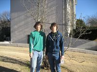
Image:2009-01-31 both.jpg| Woodveil at the hashpoint. | Image:2009-01-31 both.jpg| Woodveil at the hashpoint. | ||
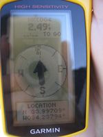
Image:2009-01-31 gps.jpg| GPS proof of location. It really was right where that tulip tree was planted. | Image:2009-01-31 gps.jpg| GPS proof of location. It really was right where that tulip tree was planted. | ||
| − | Image:2009-01-31 river wide.jpg| | + | Image:2009-01-31 river wide.jpg| These pictures are from the nearby park on the Chattahoochee River. |
Image:2009-01-31 nick geese.jpg| Nick on a rock, with geese. | Image:2009-01-31 nick geese.jpg| Nick on a rock, with geese. | ||
Image:2009-01-31 nick river.jpg| And he never fell in. | Image:2009-01-31 nick river.jpg| And he never fell in. | ||
Image:2009-01-31 river east.jpg| Another shot, looking East. | Image:2009-01-31 river east.jpg| Another shot, looking East. | ||
Image:2009-01-31 chris river.jpg| Chris on some rocks. | Image:2009-01-31 chris river.jpg| Chris on some rocks. | ||
| − | Image:2009-01-31 leap.jpg| When we come back in the spring, we can just walk around in the ankle deep water instead of | + | Image:2009-01-31 leap.jpg| When we come back in the spring, we can just walk around in the ankle deep water instead of having to jump. |
</gallery> | </gallery> | ||
| Line 41: | Line 43: | ||
{{land geohash | latitude = 33 | longitude = -84 | date = 2009-01-31 | name = [[user:NWoodruff|NWoodruff]] and [[user:Woodveil|Woodveil]]}} | {{land geohash | latitude = 33 | longitude = -84 | date = 2009-01-31 | name = [[user:NWoodruff|NWoodruff]] and [[user:Woodveil|Woodveil]]}} | ||
| − | {{ | + | {{Meet-up | latitude = 33 | longitude = -84 | date = 2009-01-31 | name = [[user:NWoodruff|NWoodruff]] and [[user:Woodveil|Woodveil]]| other = each other }} |
{{Earliest geohasher | latitude = 33 | longitude = -84 | date = 2009-01-31 | name = [[user:NWoodruff|NWoodruff]] }} | {{Earliest geohasher | latitude = 33 | longitude = -84 | date = 2009-01-31 | name = [[user:NWoodruff|NWoodruff]] }} | ||
| − | {{Ambassador | + | {{Ambassador | latitude = 33 | longitude = -84 | date = 2009-01-31 | name= [[user:NWoodruff|NWoodruff]] and [[user:Woodveil|Woodveil]]}}{{drag-along | latitude = 33 | longitude = -84 | date = 2009-01-31 | name = [[user:NWoodruff|NWoodruff]] }} |
| − | {{ | + | {{xkcd centurion | count = 1 | name = [[user:Woodveil|Woodveil]]}} |
| − | {{ | + | {{xkcd centurion | count = 6 | name = [[user:NWoodruff|NWoodruff]]}} |
[[Category:Expeditions]] | [[Category:Expeditions]] | ||
| − | |||
[[Category:Expeditions with photos]] | [[Category:Expeditions with photos]] | ||
[[Category:Coordinates reached]] | [[Category:Coordinates reached]] | ||
| + | {{location|US|GA|GW}} | ||
Latest revision as of 01:36, 8 August 2019
| Sat 31 Jan 2009 in Atlanta: 33.9971020, -84.2379434 geohashing.info google osm bing/os kml crox |
About
This was an extremely northern set of coordinates, only a matter of feet from the northern edge of the Atlanta graticule. The actual hashpoint was in a front yard, under a tree. We knocked on the front door of the closest house and were greeted by a very nice man, who gave us permission to take pictures in his yard, and also informed us the tree in question was in fact a tulip tree. This expedition was the first official xkcd meetup for the Atlanta graticule. Weather was around 50°F and sunny.
Expedition
NWoodruff
I ended up arriving around 3:45pm as I was a short drive from this location. I am also very familiar with this location as in my ex-wife's parents live within walking distance from this hash only one street over. Having lived in this area since 1976, and having gone to the park at least 5 times a summer since I was in high school, I did not make the excursion to the park after the meet up. I did forget to tell Woodveil that the squirrels do like potato chips and if you sit still enough, the squirrels will take the chips from your hand.
Woodveil
We drove up to the hash a few minutes before 4:00 pm, and NWoodruff was already there. We exchanged the customary pleasantries and took photos at the hashpoint. After NWoodruff departed, we decided to drive over to the nearby Jones Bridge Park and explore. It was spectacular!
The park's northern border is the Chattahoochee River, and the park is named for the historic Jones Bridge, which was one of the first bridges to span the river after its completion in 1904. The stretch of the Chattahoochee at the park was a few hundred feet across and very shallow, and there were a number of large rocks that protruded above the water enough to walk around on. We jumped around on the rocks for half an hour, interacting with the geese and exploring and taking pictures. We're also hoping for an extreme southern hashpoint in the Talking Rock graticule in the spring, so we can go back and wade around when the weather gets warmer. Another end of the park had the Jones Bridge, only half of which still remains. Apparently the other half was stolen in the '40s. Pretty cool stuff, and it made for a neat photo gallery. All in all, this expedition really served the original intentions of geohashing, to meet other people and explore new places. Yay.
Gallery
- Photo Gallery
Woodveil driving to the point.
Achievements
NWoodruff and Woodveil earned the Land geohash achievement
|
NWoodruff and Woodveil earned the Meet-up achievement
|
NWoodruff earned the Earliest geohasher achievement
|
NWoodruff and Woodveil earned the Ambassador achievement
|
NWoodruff earned the Drag-along achievement
|
Woodveil earned the xkcd Nullaturion achievement
|
NWoodruff earned the xkcd Nullaturion achievement
|


