Difference between revisions of "2009-03-22 40 -88"
imported>Excellentdude m (As you can see, I'm a little behind) |
m |
||
| (3 intermediate revisions by 2 users not shown) | |||
| Line 8: | Line 8: | ||
== About == | == About == | ||
| + | Today's hash was a little ways behind a gas station and McDonald's right beside an Interstate 55 exit. | ||
== Expedition == | == Expedition == | ||
| + | After a fun wedding on the day before, the time had come for me to leave [[St. Louis, Missouri|St. Louis]] and head back to [[Lansing, Michigan|mid-Michigan]]. As I did when I went to St. Louis, I consulted the days geohash coordinates to determine the route I'd take home. When I saw these coordinates and their great proximity to one of my routes home, the decision was made. | ||
| + | |||
| + | At first, when I looked at the satellite photos, I thought the coordinates were on a farm. Then I looked a little closer and saw a tall sign like gas stations near interstate exits have. The point being right off an interstate exit, I put two and two together and figured out the hash was right behind a gas station. | ||
| + | |||
| + | When I arrived, there was a gas station and a McDonald's. The tall sign turned out to be the golden arches. I filled my tank with gas, then parked beside the convenient store. I then started walking across the McDonald's drive thru and behind the complex. I wondered what someone going through the drive thru might think if they saw me walking into the apparent nothingness; however, no one was there and the thought quickly faded. The satellite photos show two somewhat large buildings behind the McDonald's. Whatever they were, they aren't there now. Only a gravel lot with some large depressions remains. I followed some large vehicle tracks from the back of the lot essentially straight back to the hash. | ||
| + | |||
| + | A short way down the tracks, I achieved the correct latitude for the hash right in front of a gate. There was a fence to my right (west). I got a GPS reading that was within my device's current tolerance for the day's hash, but I thought I could get a better one. Having seen no "No Trespassing" signs the entire time, I hopped the fence with the help of a tree branch and got to the place pictured below and took a GPS reading. It wasn't any better than what I had before, but I was more convinced that I was actually at the hash this time. | ||
| + | |||
| + | In this small patch of trees, there were a couple different deer stands. I took some pictures of those and headed back toward the gas station. Along the way, I turned and took a picture of I-55 to show how close this hash was to the interstate and the exit. A few short hours later, and I was home! | ||
== Achievements == | == Achievements == | ||
| + | {{land geohash | ||
| + | | latitude = 40 | ||
| + | | longitude = -88 | ||
| + | | date = 2009-03-22 | ||
| + | | name = [[User:excellentdude|excellentdude]] | ||
| + | }} | ||
== Photos == | == Photos == | ||
| + | <gallery perrow="5"> | ||
| + | Image:2009-03-22 40 -88 Goofy Grin.jpg|Goofy grin | ||
| + | Image:2009-03-22 40 -88 Hash.jpg|The hash | ||
| + | Image:2009-03-22 40 -88 GPS.png|GPS reading | ||
| + | Image:2009-03-22 40 -88 Deer Stand 1.jpg|One deer stand | ||
| + | Image:2009-03-22 40 -88 Deer Stand 2.jpg|The other deer stand | ||
| + | Image:2009-03-22 40 -88 Helpful Branch.jpg|The helpful branch I mentioned | ||
| + | Image:2009-03-22 40 -88 Patch.jpg|The small patch of trees containing the hash | ||
| + | Image:2009-03-22 40 -88 Gate.jpg|The gate | ||
| + | Image:2009-03-22 40 -88 Trail Behind Gas Station.jpg|Time to head back | ||
| + | Image:2009-03-22 40 -88 I-55.jpg|That's how close the highway was | ||
| + | </gallery> | ||
[[Category:Expeditions]] | [[Category:Expeditions]] | ||
| Line 20: | Line 48: | ||
[[Category:Meetup on 2009-03-22]] | [[Category:Meetup on 2009-03-22]] | ||
[[Category:Meetup in 40 -88]] | [[Category:Meetup in 40 -88]] | ||
| + | {{location|US|IL|ML}} | ||
Latest revision as of 23:12, 18 March 2022
| Sun 22 Mar 2009 in Champaign/Urbana: 40.6411888, -88.8055127 geohashing.info google osm bing/os kml crox |
Contents
About
Today's hash was a little ways behind a gas station and McDonald's right beside an Interstate 55 exit.
Expedition
After a fun wedding on the day before, the time had come for me to leave St. Louis and head back to mid-Michigan. As I did when I went to St. Louis, I consulted the days geohash coordinates to determine the route I'd take home. When I saw these coordinates and their great proximity to one of my routes home, the decision was made.
At first, when I looked at the satellite photos, I thought the coordinates were on a farm. Then I looked a little closer and saw a tall sign like gas stations near interstate exits have. The point being right off an interstate exit, I put two and two together and figured out the hash was right behind a gas station.
When I arrived, there was a gas station and a McDonald's. The tall sign turned out to be the golden arches. I filled my tank with gas, then parked beside the convenient store. I then started walking across the McDonald's drive thru and behind the complex. I wondered what someone going through the drive thru might think if they saw me walking into the apparent nothingness; however, no one was there and the thought quickly faded. The satellite photos show two somewhat large buildings behind the McDonald's. Whatever they were, they aren't there now. Only a gravel lot with some large depressions remains. I followed some large vehicle tracks from the back of the lot essentially straight back to the hash.
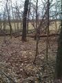
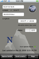
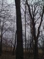
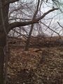
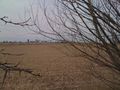
A short way down the tracks, I achieved the correct latitude for the hash right in front of a gate. There was a fence to my right (west). I got a GPS reading that was within my device's current tolerance for the day's hash, but I thought I could get a better one. Having seen no "No Trespassing" signs the entire time, I hopped the fence with the help of a tree branch and got to the place pictured below and took a GPS reading. It wasn't any better than what I had before, but I was more convinced that I was actually at the hash this time.
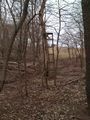
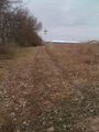
In this small patch of trees, there were a couple different deer stands. I took some pictures of those and headed back toward the gas station. Along the way, I turned and took a picture of I-55 to show how close this hash was to the interstate and the exit. A few short hours later, and I was home!
Achievements
excellentdude earned the Land geohash achievement
|
Photos

Goofy grin
The hash
GPS reading
One deer stand
The other deer stand
The helpful branch I mentioned
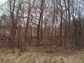
The small patch of trees containing the hash
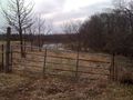
The gate
Time to head back
That's how close the highway was


