Difference between revisions of "2009-05-26 34 -84"
imported>NWoodruff m (→About) |
m (Replacing http://wiki.xkcd.com/geohashing/Talking_Rock%2C_Georgia with Talking Rock, Georgia) |
||
| (2 intermediate revisions by 2 users not shown) | |||
| Line 10: | Line 10: | ||
== Graticule == | == Graticule == | ||
| − | [ | + | [[Talking Rock, Georgia|Talking Rock]] |
== About == | == About == | ||
| Line 19: | Line 19: | ||
* [[User:NWoodruff|NWoodruff]] | * [[User:NWoodruff|NWoodruff]] | ||
| + | |||
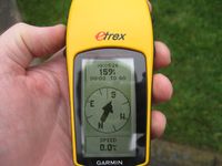
| + | I didn't need my eTrex for this hash point because it is not that far out of my way when driving home from work. I noticed that the hash point was in the back yard of someones house. I drove up on the house and took a picture of the eTrex showing 159 feet to go in case permission was not granted to access the property. | ||
| + | |||
| + | I knocked on the door of the house and James answered the door. I introduced myself and explained the world of Geohashing to him. James is a very friendly man in his late 50's to early 60's. He granted me permission to access his back yard and stayed by his front door. | ||
| + | |||
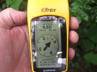
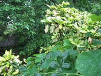
| + | I walked into his back yard in search of the hash point only to find out that the actual hash point is under a large wet bush. Me being in a suit and tie did not feel like getting on my hands and knees to make it under the bush only to get soaked. I settled on 4 feet to go and thought "Close Enough". | ||
| + | |||
| + | I took a picture of my eTrex, the bush and the back yard. I then made my way back to the front door and thanked James. I let him keep the google map and the ambassador hand out that I printed up. I also informed James on how to find this website and then made my way back to my truck to go home. | ||
| + | |||
==Expeditions== | ==Expeditions== | ||
| Line 38: | Line 47: | ||
[[Category:Coordinates reached]] | [[Category:Coordinates reached]] | ||
[[Category:Expeditions with photos]] | [[Category:Expeditions with photos]] | ||
| + | {{location|US|GA|CB}} | ||
Latest revision as of 12:40, 19 February 2020
| Tue 26 May 2009 in Talking Rock: 34.0329841, -84.5885297 geohashing.info google osm bing/os kml crox |
Contents
Graticule
About
I had checked the Atlanta map this morning for the hash point and it was way too far south for me to make it today. I then check this graticule and it was about 6 tenths of a mile out of my way driving to the Interstate from work on my way home. There is no reason why I shouldn't make this hash point.
People
I didn't need my eTrex for this hash point because it is not that far out of my way when driving home from work. I noticed that the hash point was in the back yard of someones house. I drove up on the house and took a picture of the eTrex showing 159 feet to go in case permission was not granted to access the property.
I knocked on the door of the house and James answered the door. I introduced myself and explained the world of Geohashing to him. James is a very friendly man in his late 50's to early 60's. He granted me permission to access his back yard and stayed by his front door.
I walked into his back yard in search of the hash point only to find out that the actual hash point is under a large wet bush. Me being in a suit and tie did not feel like getting on my hands and knees to make it under the bush only to get soaked. I settled on 4 feet to go and thought "Close Enough".
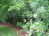
I took a picture of my eTrex, the bush and the back yard. I then made my way back to the front door and thanked James. I let him keep the google map and the ambassador hand out that I printed up. I also informed James on how to find this website and then made my way back to my truck to go home.
Expeditions
Gallery
- Photo Gallery
Nathan earned the Ambassador achievement
|
NWoodruff earned the Land geohash achievement
|


