Difference between revisions of "2009-06-04 45 -122"
imported>Aperfectring (Woo hashing!) |
m (per Renaming Proposal) |
||
| (7 intermediate revisions by 3 users not shown) | |||
| Line 18: | Line 18: | ||
After another night of jet-lag quality sleep (which consisted of sleeping until 5am, and waking every half an hour for the next two hours), I saw that the hashpoint was in the far northwest part of the graticule. I had not yet explored this part of the graticule, so I was interested in going, if for nothing other than to see what that area is like. The morning was taken up by a city tour of Portland (unpictured), which lasted until about 12:30. I got back to the hotel room around 1pm (pictured below). | After another night of jet-lag quality sleep (which consisted of sleeping until 5am, and waking every half an hour for the next two hours), I saw that the hashpoint was in the far northwest part of the graticule. I had not yet explored this part of the graticule, so I was interested in going, if for nothing other than to see what that area is like. The morning was taken up by a city tour of Portland (unpictured), which lasted until about 12:30. I got back to the hotel room around 1pm (pictured below). | ||
| − | The drive was about 1 hour long, on a mixture of dual carriageway, and winding mountain roads, both paved and gravel. During the trip, I received a call from the office, seeing if I wanted to go to dinner. I agreed, even though that would cut the time for expedition a bit on the short side. After the drive, I found a logging road which headed back into the woods towards the hash point. The sign on the gate (pictured below) didn't prohibit adventurous hikers, or even a crazy guy from Florida playing at a hiker, so I decided to continue on. | + | The drive was about 1 hour long, on a mixture of dual carriageway, and winding mountain roads, both paved and gravel. During the trip, I received a call from the office, seeing if I wanted to go to dinner. I agreed, even though that would cut the time for expedition a bit on the short side. After the drive, I found a logging road which headed back into the woods towards the hash point. The sign on the gate (pictured below) didn't prohibit adventurous hikers, or even a crazy guy from Florida playing at being a hiker, so I decided to continue on. |
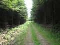
The entrance to the logging road was approximately 1 mile (1.6 km) from the hashpoint, as the crow flies. I began the trek inward shortly after 2:30. Most of the journey was along gravel/stone logging roads (pictured below), weaving back and forth, up and down the whole way. There were many forks, and as I was venturing back in I was hoping that I remembered the way out. | The entrance to the logging road was approximately 1 mile (1.6 km) from the hashpoint, as the crow flies. I began the trek inward shortly after 2:30. Most of the journey was along gravel/stone logging roads (pictured below), weaving back and forth, up and down the whole way. There were many forks, and as I was venturing back in I was hoping that I remembered the way out. | ||
With about 750 ft (250m) left to go, the logging road changed from gravel to completely unused for quite some time. After hoping over a couple of fallen trees (pictured below), the road was overgrown with many weeds, some of them thorny (pictured below). In my, completely insane, wisdom, I chose to wear long pants to the hashpoint, so the thorns weren't too much of a bother, so long as I weaved, like a drunken sailor, down the "road". 350ft (100m) away from the hashpoint was the closest I could get on said "road", and since I was running low on time, and decided dying a lonely death in a secluded part of the woods was not a fun thing to do, I gave up (pictured below). At this point it was around 3:00, so I headed back to the car, which I reached around 3:30. The trip back was mostly uneventful, primarily comprised of me sweating profusely from the brisk hiking I had been participating in. | With about 750 ft (250m) left to go, the logging road changed from gravel to completely unused for quite some time. After hoping over a couple of fallen trees (pictured below), the road was overgrown with many weeds, some of them thorny (pictured below). In my, completely insane, wisdom, I chose to wear long pants to the hashpoint, so the thorns weren't too much of a bother, so long as I weaved, like a drunken sailor, down the "road". 350ft (100m) away from the hashpoint was the closest I could get on said "road", and since I was running low on time, and decided dying a lonely death in a secluded part of the woods was not a fun thing to do, I gave up (pictured below). At this point it was around 3:00, so I headed back to the car, which I reached around 3:30. The trip back was mostly uneventful, primarily comprised of me sweating profusely from the brisk hiking I had been participating in. | ||
| + | |||
| + | == Achievements == | ||
| + | {{done with nature | ||
| + | |||
| + | | latitude = 45 | ||
| + | | longitude = -122 | ||
| + | | date = 2009-06-04 | ||
| + | | name = aperfectring | ||
| + | | image = 2009-06-04_45_-122_014.jpg | ||
| + | |||
| + | }} | ||
| + | |||
| + | == Tracklog == | ||
| + | [http://www.everytrail.com/view_trip.php?trip_id=237199 here] | ||
= Gallery = | = Gallery = | ||
| − | + | <gallery> | |
| + | Image:2009-06-04_45_-122_001.jpg|Huge hotel living room. | ||
| + | Image:2009-06-04_45_-122_002.jpg|Huge hotel kitchen. | ||
| + | Image:2009-06-04_45_-122_003.jpg|Huge hotel bathroom. | ||
| + | Image:2009-06-04_45_-122_004.jpg|Huge hotel bedroom. | ||
| + | Image:2009-06-04_45_-122_016.jpg|Gate preventing vehicle entry, but idiots on foot are allowed! | ||
| + | Image:2009-06-04_45_-122_005.jpg|Logging road. | ||
| + | Image:2009-06-04_45_-122_006.jpg|More logging road. | ||
| + | Image:2009-06-04_45_-122_007.jpg|Another logging road. | ||
| + | Image:2009-06-04_45_-122_008.jpg|Have you had enough of the logging roads yet? | ||
| + | Image:2009-06-04_45_-122_011.jpg|Too bad, you get more logging road. | ||
| + | Image:2009-06-04_45_-122_015.jpg|And now for something completely different, an overgrown logging road with downed trees. | ||
| + | Image:2009-06-04_45_-122_012.jpg|More overgrown logging road. | ||
| + | Image:2009-06-04_45_-122_013.jpg|Proof of failure. | ||
| + | Image:2009-06-04_45_-122_014.jpg|What failure may look like. | ||
| + | Image:2009-06-04_45_-122_009.jpg|A nice creek passed on the way. | ||
| + | Image:2009-06-04_45_-122_010.jpg|The other way on the creek. | ||
| + | </gallery> | ||
[[Category:Expeditions]] | [[Category:Expeditions]] | ||
| Line 31: | Line 62: | ||
[[Category:Coordinates not reached]] | [[Category:Coordinates not reached]] | ||
[[Category:Not reached - Mother Nature]] | [[Category:Not reached - Mother Nature]] | ||
| + | {{location|US|OR|CL}} | ||
Latest revision as of 14:44, 2 April 2024
| Thu 4 Jun 2009 in Portland, Oregon: 45.9745098, -122.9838037 geohashing.info google osm bing/os kml crox |
Participants
Plans
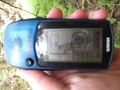
Aperfectring noticed that the point was in what appeared to be a good exploring area, so he decided to go to it. Preparations were gathering old shoes, and programming the GPS unit(s).
Expedition
After another night of jet-lag quality sleep (which consisted of sleeping until 5am, and waking every half an hour for the next two hours), I saw that the hashpoint was in the far northwest part of the graticule. I had not yet explored this part of the graticule, so I was interested in going, if for nothing other than to see what that area is like. The morning was taken up by a city tour of Portland (unpictured), which lasted until about 12:30. I got back to the hotel room around 1pm (pictured below).
The drive was about 1 hour long, on a mixture of dual carriageway, and winding mountain roads, both paved and gravel. During the trip, I received a call from the office, seeing if I wanted to go to dinner. I agreed, even though that would cut the time for expedition a bit on the short side. After the drive, I found a logging road which headed back into the woods towards the hash point. The sign on the gate (pictured below) didn't prohibit adventurous hikers, or even a crazy guy from Florida playing at being a hiker, so I decided to continue on.
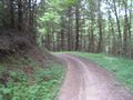
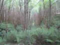
The entrance to the logging road was approximately 1 mile (1.6 km) from the hashpoint, as the crow flies. I began the trek inward shortly after 2:30. Most of the journey was along gravel/stone logging roads (pictured below), weaving back and forth, up and down the whole way. There were many forks, and as I was venturing back in I was hoping that I remembered the way out.
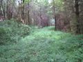
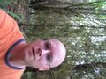
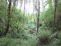
With about 750 ft (250m) left to go, the logging road changed from gravel to completely unused for quite some time. After hoping over a couple of fallen trees (pictured below), the road was overgrown with many weeds, some of them thorny (pictured below). In my, completely insane, wisdom, I chose to wear long pants to the hashpoint, so the thorns weren't too much of a bother, so long as I weaved, like a drunken sailor, down the "road". 350ft (100m) away from the hashpoint was the closest I could get on said "road", and since I was running low on time, and decided dying a lonely death in a secluded part of the woods was not a fun thing to do, I gave up (pictured below). At this point it was around 3:00, so I headed back to the car, which I reached around 3:30. The trip back was mostly uneventful, primarily comprised of me sweating profusely from the brisk hiking I had been participating in.
Achievements
aperfectring earned the Done with Nature consolation prize
|
Tracklog
Gallery
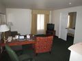
Huge hotel living room.
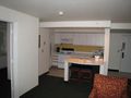
Huge hotel kitchen.
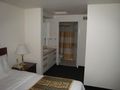
Huge hotel bathroom.
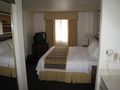
Huge hotel bedroom.
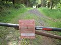
Gate preventing vehicle entry, but idiots on foot are allowed!
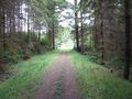
Logging road.
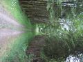
More logging road.
Another logging road.
Have you had enough of the logging roads yet?
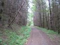
Too bad, you get more logging road.
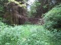
And now for something completely different, an overgrown logging road with downed trees.
More overgrown logging road.
Proof of failure.
What failure may look like.
A nice creek passed on the way.
The other way on the creek.


