Difference between revisions of "2009-07-11 43 -79"
imported>Splitdipless (One of these days I'll make a post and not screw it up on the first post...) |
imported>FippeBot m (Location) |
||
| (One intermediate revision by one other user not shown) | |||
| Line 25: | Line 25: | ||
== Photos == | == Photos == | ||
| − | |||
| − | |||
| − | |||
<gallery perrow="1"> | <gallery perrow="1"> | ||
| Line 36: | Line 33: | ||
[[Category:Expeditions]] | [[Category:Expeditions]] | ||
[[Category:Coordinates not reached]] | [[Category:Coordinates not reached]] | ||
| − | [[Category:Not reached - | + | [[Category:Not reached - Attended alternate location]] |
[[Category:Meetup on 2009-07-11]] | [[Category:Meetup on 2009-07-11]] | ||
[[Category:Meetup in 43 -79]] | [[Category:Meetup in 43 -79]] | ||
| + | {{location|CA|ON}} | ||
Latest revision as of 04:26, 8 August 2019
| Sat 11 Jul 2009 in Toronto: 43.3206566, -79.1604565 geohashing.info google osm bing/os kml crox |
Contents
About
Today's point was in Lake Ontario.
Expedition
Splitdipless
Having fun with the data, I decided to embark on a driving adventure around town. Honda Indy was in town after all.
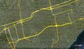
Taking today's point and expanding it to every possible decihash, I then eliminated all the points that didn't appear on public streets. As it turned out, 5% of all the decihashes where on public roadways. I eliminated one point because of distance, then came up with a reasonable route to take me to all remaining 4 points.
Waypoint 3 was on McNicoll between McCowan and Markham (Hwy 48) in Scarborough. Waypoint 2 was on Hwy 404 north of Steeles and south of Hwy 7 near Markham. Waypoint 1 was on Worth Blvd west of Bathurst and North of Beverly Glen in Thornhill. The final point was on a block west of Islington on Redwater north of Leduc and south of Elmhurst in Etobicoke. I started At Yonge (Hwy 11) and Hwy 401 near the bottom centre of the map and worked my way counterclockwise.
The last point was out South West of Hamilton on Hwy 403, and would have taken too long to get to.
I forgot my camera, but I did get a track using my GPS. A picture of the overall course is attached.
Photos
Not a bad alternative to swimming.
