Difference between revisions of "2009-07-21 51 11"
imported>Reinhard (hash report) |
imported>FippeBot m (Location) |
||
| (2 intermediate revisions by one other user not shown) | |||
| Line 5: | Line 5: | ||
| date=2009-07-21 | | date=2009-07-21 | ||
}} | }} | ||
| + | == Participants == | ||
| + | * [[User:Manu|Manu]] | ||
| + | * [[User:Reinhard|Reinhard]] | ||
| − | The hashpoint was located in a small industrial area near Apolda, which is only about 10 km from the place where Reinhard lives. [[user:Manu|Manu]] (who | + | == Expedition == |
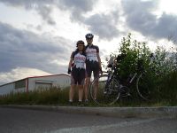
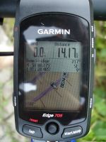
| + | The hashpoint was located in a small industrial area near Apolda, which is only about 10 km from the place where Reinhard lives. [[user:Manu|Manu]] (who had come from Leipzig in the evening) and [[User:Reinhard|Reinhard]] decided to go for a small (33 km) bike trip and visit the hashpoint, which was only few meters from the next road. Everything went well until Reinhard noticed that there wasn't the usual flag visible in his Garmin, showing the coordinates. He remembered that he had fed his Garmin with the coordinates as he always did, but this time the coordinates obviously weren't saved. Unfortunately, Reinhard this time also hadn't prepared the track (the violet line on his display) to go directly to the hashpoint, but only along the road passing it. Manu and Reinhard didn't want to turn around after 14 km just to get the coordinates from the internet and annoyingly they couldn't phone [[User:Paintedhell|Juja]] to ask her for the coordinates, because she also had no internet access at that time. | ||
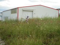
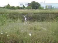
| − | So they had to trust the blurry satellite view with the hashpoint marker that Reinhard still had in mind. Since he usually could rely on the memory of his Garmin, he hadn't had a close look at the view beforehand. To make it a successful expedition, nevertheless, Reinhard took his Garmin off the bike and did a meander-shaped walk through the headhigh weed near the white building he remembered from the satellite view, while Manu was busy taking photos of him doing this silly thing. After that Manu did a quite similar walk to raise her chance of a successful expedition as well. | + | So they had to trust the blurry satellite view with the hashpoint marker that Reinhard still had in mind. Since he usually could rely on the memory of his Garmin, he hadn't had a close look at the view beforehand. To make it a successful expedition, nevertheless, Reinhard took his Garmin off the bike and did a meander-shaped walk through the headhigh weed near the white building he remembered from the satellite view, while Manu was busy taking photos of him doing this silly thing. After that, Manu did a quite similar walk to raise her chance of a successful expedition as well. |
After doing that frustrating job, they rode back to Reinhard's home and were curious, whether they really hit the coordinates, and - see picture 6 - they did! Coordinates reached! | After doing that frustrating job, they rode back to Reinhard's home and were curious, whether they really hit the coordinates, and - see picture 6 - they did! Coordinates reached! | ||
| Line 25: | Line 29: | ||
[[Category:Expeditions with photos]] | [[Category:Expeditions with photos]] | ||
[[Category:Coordinates reached]] | [[Category:Coordinates reached]] | ||
| + | {{location|DE|TH|AP}} | ||
Latest revision as of 04:41, 8 August 2019
| Tue 21 Jul 2009 in 51,11: 51.0130359, 11.4742963 geohashing.info google osm bing/os kml crox |
Participants
Expedition
The hashpoint was located in a small industrial area near Apolda, which is only about 10 km from the place where Reinhard lives. Manu (who had come from Leipzig in the evening) and Reinhard decided to go for a small (33 km) bike trip and visit the hashpoint, which was only few meters from the next road. Everything went well until Reinhard noticed that there wasn't the usual flag visible in his Garmin, showing the coordinates. He remembered that he had fed his Garmin with the coordinates as he always did, but this time the coordinates obviously weren't saved. Unfortunately, Reinhard this time also hadn't prepared the track (the violet line on his display) to go directly to the hashpoint, but only along the road passing it. Manu and Reinhard didn't want to turn around after 14 km just to get the coordinates from the internet and annoyingly they couldn't phone Juja to ask her for the coordinates, because she also had no internet access at that time.
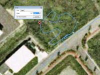
So they had to trust the blurry satellite view with the hashpoint marker that Reinhard still had in mind. Since he usually could rely on the memory of his Garmin, he hadn't had a close look at the view beforehand. To make it a successful expedition, nevertheless, Reinhard took his Garmin off the bike and did a meander-shaped walk through the headhigh weed near the white building he remembered from the satellite view, while Manu was busy taking photos of him doing this silly thing. After that, Manu did a quite similar walk to raise her chance of a successful expedition as well.
After doing that frustrating job, they rode back to Reinhard's home and were curious, whether they really hit the coordinates, and - see picture 6 - they did! Coordinates reached!
- Photo Gallery
