Difference between revisions of "2009-08-08 48 -123"
imported>Elbie m (→Elbie: don't have time to bike Ladner-to-Tsawwassen for this one) |
m (More specific location) |
||
| (8 intermediate revisions by 3 users not shown) | |||
| Line 1: | Line 1: | ||
| − | |||
| − | |||
| − | |||
| − | |||
{{meetup graticule | {{meetup graticule | ||
| lat=48 | | lat=48 | ||
| Line 9: | Line 5: | ||
}} | }} | ||
| − | |||
__NOTOC__ | __NOTOC__ | ||
== Location == | == Location == | ||
| Line 18: | Line 13: | ||
* [[User:Wenslayer|Wenslayer]]: This is less than 12km from my home; therefore, I must go. | * [[User:Wenslayer|Wenslayer]]: This is less than 12km from my home; therefore, I must go. | ||
| − | |||
== Plans == | == Plans == | ||
| Line 27: | Line 21: | ||
Will retreat to nearby Gore Park for games. | Will retreat to nearby Gore Park for games. | ||
| − | + | '''Note for any bicyclists coming from the ferry terminal''': | |
| − | + | : I'd like to suggest this path from the Schwartz Bay ferry terminal to avoid steep hills: | |
| + | :* Get on the Lochside Trail | ||
| + | :* Take a right at McTavish Road, and cross the Pat Bay Hwy | ||
| + | :* Take a left at East Saanich Road | ||
| + | :* As you get close to Saanichton, take a right onto Wallace Drive. | ||
| + | :* Cross West Saanich Road, going through Brentwood Bay, and then take a left at Benvenuto Drive. | ||
| − | + | : These roads are quiet and you'll get a chance to see some of the lovely Saanich peninsula (one of my favorite places to ride through). | |
| − | |||
| − | |||
| − | |||
| − | |||
| − | + | :BTW, here's a [http://maps.google.com/maps?f=d&source=s_d&saddr=2208+Dolphin+Rd,+North+Saanich,+BC,+Canada+(Swartz+Bay)&daddr=48.671013,-123.420582+to:Resthaven+Dr+to:5th+St+to:E+Saanich+Rd+to:Wallace+Dr+to:%2B48%C2%B0+33%27+52.50%22,+-123%C2%B0+27%27+9.87%22+(48.564585,+-123.452741)&hl=en&geocode=FYfk5gIdLu6k-CGUVLq_i2w1tA%3B%3BFSaW5gId1dmk-A%3BFWs45gIddg-l-A%3BFfYC5gIdtsGk-A%3BFbkN5QIdPiKk-A%3BFWcJ5QIdukKk-A&mra=dpe&mrcr=0&mrsp=1&sz=13&via=1,2,3,4,5&dirflg=h&sll=48.635972,-123.42453&sspn=0.102664,0.109692&ie=UTF8&ll=48.616342,-123.413887&spn=0.205407,0.219383&z=12 Google Map Directions link]. Just ignore the portion from the ferry to 5th St and Ocean Ave in Sidney, since the Lochside trail isn't on the map. | |
== Expedition == | == Expedition == | ||
| − | + | Due to events beyond my control, I was unsure as to when I'd be able to set off and under what mode of transportation I could use for this expedition. I had thought I would have plenty of time to ride out there, perhaps even with my son in tow in a trailer. However, with an impromptu trip to the pool with my girls while my son napped, combined with a pending family dinner, I realized I wouldn't have as much time as I had hoped. | |
| + | |||
| + | I packed up my camera, printouts of the location, including the [[Ambassador|Diplomatic Letter]], grabbed my son and off we went in our "Rocket" (as my 5-year old likes to call our vehicle, a reference to the [http://en.wikipedia.org/wiki/Little_Einsteins Little Einsteins] primary mode of transportation). I paused to start my GPS tracklog and away we went. | ||
| + | |||
| + | We drove easily enough out to the location, only taking us less than 10 minutes. I turned into the entrance to the [http://www.benvenutobandb.com/ Benvenuto B&B], where there was a rather open-air shed with an interesting carved statue out front. I hunted down the Geohash coordinate, snapped a picture, and then investigated the shed. I took a few more pics with my son, and then we headed off for Gore Park. | ||
| + | |||
| + | On the way there, we encountered a deer loping along between the road and fence along a property. I got a few pics of the majestic creature before it scampered off. We reached Gore Park, got out and briefly hiked around before returning to the car and back home via an alternate route. | ||
== Tracklog == | == Tracklog == | ||
| Line 48: | Line 49: | ||
== Photos == | == Photos == | ||
| − | + | <gallery perrow="4"> | |
| − | + | Image:2009-08-08 48 -123 GPS.jpg | Made it! | |
| − | <gallery perrow=" | + | Image:2009-08-08 48 -123 tree.jpg | That tree was the Geohash location. |
| − | Image:2009- | + | Image:2009-08-08 48 -123 son statue.jpg | [[User:Wenslayer|Wenslayer]]'s son and the lumberjack. |
| − | Image:2009- | + | Image:2009-08-08 48 -123 shed.jpg | Nicest looking shed I've ever seen. |
| + | Image:2009-08-08 48 -123 spider.jpg | A spider checking us out. | ||
| + | Image:2009-08-08 48 -123 son and i.jpg | [[User:Wenslayer|Wenslayer]] and his son, the trusty copilot. | ||
| + | Image:2009-08-08 48 -123 xkcd.jpg | X(KCD) marks the spot. | ||
| + | Image:2009-08-08 48 -123 benvenuto.jpg | The (apparently busy) [http://www.benvenutobandb.com/ Benvenuto B&B]. | ||
| + | Image:2009-08-08 48 -123 benvenuto2.jpg | Looking up the driveway to the [http://www.benvenutobandb.com/ Benvenuto B&B]. | ||
| + | Image:2009-08-08 48 -123 deer.jpg | Which way to Gore Park? | ||
| + | Image:2009-08-08 48 -123 gorepark.jpg | Welcome to Gore Park. | ||
| + | Image:2009-08-08 48 -123 son park.jpg | My son playing with his car in Gore Park. | ||
</gallery> | </gallery> | ||
| − | + | [[Category:Expeditions]] | |
| − | + | [[Category:Expeditions with photos]] | |
| − | |||
| − | [[Category: | ||
| − | |||
<!-- An actual expedition: | <!-- An actual expedition: | ||
| − | |||
-- and one or more of -- | -- and one or more of -- | ||
| − | |||
| − | |||
| − | |||
[[Category:Expedition without GPS]] | [[Category:Expedition without GPS]] | ||
--> | --> | ||
| − | |||
[[Category:Coordinates reached]] | [[Category:Coordinates reached]] | ||
| − | |||
| − | + | == Achievements == | |
| − | + | ||
| − | + | {{:User:Wenslayer/Achievement Land}} | |
| − | + | {{location|CA|BC|CP}} | |
| − | |||
| − | |||
| − | |||
| − | |||
Latest revision as of 23:10, 9 August 2020
| Sat 8 Aug 2009 in 48,-123: 48.5645846, -123.4527411 geohashing.info google osm bing/os kml crox |
Location
Looks like it's in some bushes right off Benvenuto Avenue, the road to Butchart Gardens. Might turn into an Ambassador Geohash.
Participants
- Wenslayer: This is less than 12km from my home; therefore, I must go.
Plans
Wenslayer
Wenslayer: I plan to be there at 4pm, either alone, with the whole family, or with some subset of my kids, depending on what's going on tomorrow.
Will retreat to nearby Gore Park for games.
Note for any bicyclists coming from the ferry terminal:
- I'd like to suggest this path from the Schwartz Bay ferry terminal to avoid steep hills:
- Get on the Lochside Trail
- Take a right at McTavish Road, and cross the Pat Bay Hwy
- Take a left at East Saanich Road
- As you get close to Saanichton, take a right onto Wallace Drive.
- Cross West Saanich Road, going through Brentwood Bay, and then take a left at Benvenuto Drive.
- These roads are quiet and you'll get a chance to see some of the lovely Saanich peninsula (one of my favorite places to ride through).
- BTW, here's a Google Map Directions link. Just ignore the portion from the ferry to 5th St and Ocean Ave in Sidney, since the Lochside trail isn't on the map.
Expedition
Due to events beyond my control, I was unsure as to when I'd be able to set off and under what mode of transportation I could use for this expedition. I had thought I would have plenty of time to ride out there, perhaps even with my son in tow in a trailer. However, with an impromptu trip to the pool with my girls while my son napped, combined with a pending family dinner, I realized I wouldn't have as much time as I had hoped.
I packed up my camera, printouts of the location, including the Diplomatic Letter, grabbed my son and off we went in our "Rocket" (as my 5-year old likes to call our vehicle, a reference to the Little Einsteins primary mode of transportation). I paused to start my GPS tracklog and away we went.
We drove easily enough out to the location, only taking us less than 10 minutes. I turned into the entrance to the Benvenuto B&B, where there was a rather open-air shed with an interesting carved statue out front. I hunted down the Geohash coordinate, snapped a picture, and then investigated the shed. I took a few more pics with my son, and then we headed off for Gore Park.
On the way there, we encountered a deer loping along between the road and fence along a property. I got a few pics of the majestic creature before it scampered off. We reached Gore Park, got out and briefly hiked around before returning to the car and back home via an alternate route.
Tracklog
I intend to do this, perhaps to get a Tron achievement.
Photos
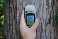
Made it!
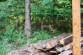
That tree was the Geohash location.

Wenslayer's son and the lumberjack.
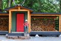
Nicest looking shed I've ever seen.
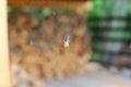
A spider checking us out.

Wenslayer and his son, the trusty copilot.
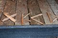
X(KCD) marks the spot.
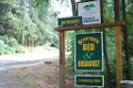
The (apparently busy) Benvenuto B&B.
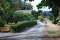
Looking up the driveway to the Benvenuto B&B.
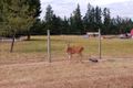
Which way to Gore Park?
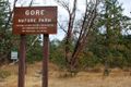
Welcome to Gore Park.
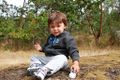
My son playing with his car in Gore Park.


Achievements
Wenslayer earned the Land geohash achievement
|