Difference between revisions of "2009-10-06 43 -79"
From Geohashing
imported>Splitdipless |
m (More specific location) |
||
| (5 intermediate revisions by 4 users not shown) | |||
| Line 1: | Line 1: | ||
| − | |||
| − | |||
| − | |||
| − | |||
{{meetup graticule | {{meetup graticule | ||
| lat=43 | | lat=43 | ||
| Line 9: | Line 5: | ||
}} | }} | ||
| − | |||
== Location == | == Location == | ||
| Line 21: | Line 16: | ||
Not exactly on the way to where I was going, and being in a farm field usually means running into a fence, but I had to get back on the geohashing horse, so to speak. | Not exactly on the way to where I was going, and being in a farm field usually means running into a fence, but I had to get back on the geohashing horse, so to speak. | ||
| − | Setting out from work in 'Em,' I stopped on the shoulder reasonably close to the point. Walking along the shoulder, not only was I confronted by a rather dangerous looking fence, but also several guard cows. No attempt was made to ask the | + | Setting out from work in 'Em,' I stopped on the shoulder reasonably close to the point. Walking along the shoulder, not only was I confronted by a rather dangerous looking fence, but also several guard cows. No attempt was made to ask the owner to enter the field due to the vicious bovine threat, and schedule commitments. |
== Photos == | == Photos == | ||
| Line 29: | Line 24: | ||
Image:2009-10-06 43 -79 B.JPG | Farm house and 'Em' in distance. | Image:2009-10-06 43 -79 B.JPG | Farm house and 'Em' in distance. | ||
Image:2009-10-06 43 -79 C.JPG | 51 m too far. | Image:2009-10-06 43 -79 C.JPG | 51 m too far. | ||
| − | </gallery | + | </gallery> |
| + | == Achievements == | ||
| + | {{#vardefine:ribbonwidth|800px}} | ||
| + | {{Two to the N achievement | ||
| + | |||
| + | | count = 3 | ||
| + | | date = 2009-10-06 | ||
| + | | latitude = 43 | ||
| + | | longitude = -79 | ||
| + | | name = Splitdipless | ||
| + | |||
| + | }} | ||
[[Category:Expeditions]] | [[Category:Expeditions]] | ||
[[Category:Expeditions with photos]] | [[Category:Expeditions with photos]] | ||
| − | [[Category:Coordinates reached]] | + | [[Category:Coordinates not reached]] |
| + | [[Category:Not reached - No public access]] | ||
| + | {{location|CA|ON|DR}} | ||
Latest revision as of 23:13, 9 August 2020
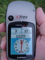
| Tue 6 Oct 2009 in 43,-79: 43.9866839, -79.0368643 geohashing.info google osm bing/os kml crox |
Location
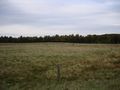
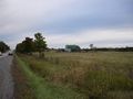
Today's hash landed in a farmer's field north of Whitby, ON north of Highway 7.
Expedition
Splitdipless
Not exactly on the way to where I was going, and being in a farm field usually means running into a fence, but I had to get back on the geohashing horse, so to speak.
Setting out from work in 'Em,' I stopped on the shoulder reasonably close to the point. Walking along the shoulder, not only was I confronted by a rather dangerous looking fence, but also several guard cows. No attempt was made to ask the owner to enter the field due to the vicious bovine threat, and schedule commitments.
Photos
An udder threat to my life.
Farm house and 'Em' in distance.
51 m too far.


Achievements
Splitdipless earned the Two to the N achievement
|