Difference between revisions of "2009-10-19 34 -84"
(New page: {{meetup graticule | map=<map lat="34" lon="-84" date="2009-10-05" /> | lat=34 | lon=-84 | date=2009-10-05 | graticule_name=Roswell | graticule_link=Roswell, Georgia }} == Graticule == ...) |
m (Replacing http://wiki.xkcd.com/geohashing/Roswell%2C_Georgia with Roswell, Georgia) |
||
| (3 intermediate revisions by 3 users not shown) | |||
| Line 1: | Line 1: | ||
{{meetup graticule | {{meetup graticule | ||
| − | | map=<map lat="34" lon="-84" date="2009-10- | + | | map=<map lat="34" lon="-84" date="2009-10-19" /> |
| lat=34 | | lat=34 | ||
| lon=-84 | | lon=-84 | ||
| − | | date=2009-10- | + | | date=2009-10-19 |
| graticule_name=Roswell | | graticule_name=Roswell | ||
| graticule_link=Roswell, Georgia | | graticule_link=Roswell, Georgia | ||
| Line 10: | Line 10: | ||
== Graticule == | == Graticule == | ||
| − | [ | + | [[Roswell, Georgia|Roswell]] |
== About == | == About == | ||
| Line 39: | Line 39: | ||
== Gallery == | == Gallery == | ||
<gallery caption="Photo Gallery" widths="200px" heights="200px" perrow="3"> | <gallery caption="Photo Gallery" widths="200px" heights="200px" perrow="3"> | ||
| − | Image:200921019_34_-84NW01.JPG| | + | Image:200921019_34_-84NW01.JPG| 8.55 feet to go. Close enough. |
| + | Image:200921019_34_-84NW02.JPG| Time of the meetup. | ||
</gallery> | </gallery> | ||
| Line 50: | Line 51: | ||
[[Category:Coordinates reached]] | [[Category:Coordinates reached]] | ||
[[Category:Expeditions with photos]] | [[Category:Expeditions with photos]] | ||
| + | {{location|US|GA|PA}} | ||
Latest revision as of 12:24, 19 February 2020
| Mon 19 Oct 2009 in Roswell: 34.0744045, -84.8316621 geohashing.info google osm bing/os kml crox |
Graticule
About
South of Cartersville Georgia, on a ranchers land.
People
I took time at lunch to drive over to south Cartersville. I followed Google map direction and the last road that Google said to turn down was actually a driveway. It had a mail box at the end of it.
I carefully drove up the steep driveway in my truck. As I crested the small hill, I noticed a man with a truck and a trailer, he was loading horses into the trailer. I got out and introduced myself.
I explained some about Geohashing and kept pointing to the Google map that I had in my hand. He started to look bewildered about my explanation. I started to explain that people all over the world do this every day as a way of a spontaneous adventure.
He then looked like he had a question to ask so I stopped talking. He then said, "So, to get this straight, you said all of that to ask to walk over there and take a picture?" I then said "Well, yea." Without a pause he said "Okay" and went back to loading the horses. Permission granted?
I walk over to the fence where he has a rope pulled between two fence posts. I duck under the rope and walk the 250 feet to the hash point. I do the GPS dance and take a picture or two.
I walk back to my truck and the guy asked if I found what I was looking for. I said "Yes, I did and thanks." He says, "Have a nice day".
I then drive back to Kennesaw and back to work.
Expeditions
Gallery
- Photo Gallery
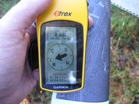
8.55 feet to go. Close enough.
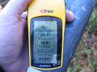
Time of the meetup.


Achievements
NWoodruff earned the Land geohash achievement
|