Difference between revisions of "2009-11-28 45 -122"
imported>Michael5000 (→Location) |
imported>FippeBot m (Location) |
||
| (6 intermediate revisions by 2 users not shown) | |||
| Line 17: | Line 17: | ||
== Participants == | == Participants == | ||
| + | *[[User:michael5000|michael5000]] | ||
| − | == | + | == Expedition == |
| − | == Expedition == | + | ===michael5000's Expedition=== |
| + | |||
| + | I ducked out of our ongoing bathroom remodeling fiasco to make a run to the plumbing store and, oh yeah, make a three-hour geohashing expedition into the hills of Southwest Washington. The hash point was actually '''on''' a logging road, making me hope that I could easily walk right to it, or maybe even drive up to it if the road was in good enough condition. | ||
| + | |||
| + | Arriving in the hash area on rural Sunset Falls Road, I had the increasingly familiar problem of resolving map, aerial image, and real world. My best point of attack seemed to be a gated logging road a ways east of where I had expected to leave pavement. Since this road swung immediately back to the west, I hoped that it might link up with other roads or paths that could get me to the hashpoint. | ||
| + | |||
| + | No such luck. After vaulting the gate (signs suggested that the timber company owning the land welcomed courteous guests) and hiking about a kilometer up, I reached a discouraging viewpoint across two steep draws and more than a kilometer of thick scrub to the area where I knew the point would be found. It would be way too much bushwhacking than I had bargained for, so I retreated back down the hill. | ||
| + | |||
| + | Having figured out the local geography from this first hike, though, I was able to find the correct logging road entrance about 1.5 km to the west (I had mistaken it for a driveway earlier). From there, it was little more than a pleasant 2 km walk up through the woods to the hash point. There was no sign that anyone had been around recently, but I built a little cairn with a note on the off chance that a late afternoon geohasher followed me up. Having forgotten to eat lunch, I was mighty glad to get back to the truck. | ||
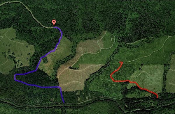
| + | '''Red = the wrong way to the hashpoint.''' | ||
| − | = | + | '''Purple = the right way to the hashpoint.''' |
| + | [[Image:2009-11-28 45 -122 Right and Wrong.jpg|center|600px]] | ||
== Photos == | == Photos == | ||
| − | + | ||
| − | |||
| − | |||
| − | |||
| − | |||
<gallery perrow="4"> | <gallery perrow="4"> | ||
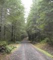
| − | + | Image:2009-11-28 45 -122 Up the Road.JPG | The right road up to the hash point. | |
| + | Image:2009-11-28 45 -122 View From the Hash.JPG | View to the southeast from near the hash point. | ||
| + | Image:2009-11-28 45 -122 CB at the Hash.JPG | Do bears geohash in the woods? | ||
| + | Image:2009-11-28 45 -122 Cairn.JPG | A monument to the 2009-11-28 45 -122 hash point, except not in the middle of the road. | ||
</gallery> | </gallery> | ||
| − | |||
| − | |||
| − | |||
| − | |||
| − | |||
| − | |||
| − | |||
[[Category:Expeditions]] | [[Category:Expeditions]] | ||
| − | |||
[[Category:Expeditions with photos]] | [[Category:Expeditions with photos]] | ||
| − | |||
[[Category:Expedition without GPS]] | [[Category:Expedition without GPS]] | ||
| − | |||
| − | |||
| − | |||
[[Category:Coordinates reached]] | [[Category:Coordinates reached]] | ||
| − | + | {{location|US|WA|CR}} | |
| − | |||
| − | |||
| − | |||
| − | |||
| − | |||
| − | |||
| − | |||
| − | |||
| − | |||
Latest revision as of 06:57, 8 August 2019
| Sat 28 Nov 2009 in 45,-122: 45.8241903, -122.3159675 geohashing.info google osm bing/os kml crox |
Location
Logging Roads north of the East Fork Lewis River in Southwest Washington.
Participants
Expedition
michael5000's Expedition
I ducked out of our ongoing bathroom remodeling fiasco to make a run to the plumbing store and, oh yeah, make a three-hour geohashing expedition into the hills of Southwest Washington. The hash point was actually on a logging road, making me hope that I could easily walk right to it, or maybe even drive up to it if the road was in good enough condition.
Arriving in the hash area on rural Sunset Falls Road, I had the increasingly familiar problem of resolving map, aerial image, and real world. My best point of attack seemed to be a gated logging road a ways east of where I had expected to leave pavement. Since this road swung immediately back to the west, I hoped that it might link up with other roads or paths that could get me to the hashpoint.
No such luck. After vaulting the gate (signs suggested that the timber company owning the land welcomed courteous guests) and hiking about a kilometer up, I reached a discouraging viewpoint across two steep draws and more than a kilometer of thick scrub to the area where I knew the point would be found. It would be way too much bushwhacking than I had bargained for, so I retreated back down the hill.
Having figured out the local geography from this first hike, though, I was able to find the correct logging road entrance about 1.5 km to the west (I had mistaken it for a driveway earlier). From there, it was little more than a pleasant 2 km walk up through the woods to the hash point. There was no sign that anyone had been around recently, but I built a little cairn with a note on the off chance that a late afternoon geohasher followed me up. Having forgotten to eat lunch, I was mighty glad to get back to the truck.
Red = the wrong way to the hashpoint.
Purple = the right way to the hashpoint.


