Difference between revisions of "2010-01-16 48 11"
imported>Harleydavidsonandy (Created page with '{{meetup graticule | lat=48 | lon=11 | date=2010-01-16 | graticule_name=Grafing | graticule_link=Munich, Germany}} == About == East of Grafing in a little Forest. [http://irc.p…') |
m (fix, sorry) |
||
| (6 intermediate revisions by 4 users not shown) | |||
| Line 9: | Line 9: | ||
East of Grafing in a little Forest. | East of Grafing in a little Forest. | ||
| − | + | {{egl|2010-01-06|48|11|text=Link to the location}} | |
| Line 15: | Line 15: | ||
== Expeditions == | == Expeditions == | ||
===[[User:Harleydavidsonandy|Harleydavidsonandy]]=== | ===[[User:Harleydavidsonandy|Harleydavidsonandy]]=== | ||
| + | On this morning, I worked on speeding up my GSAK macro for GeoHashing on the newly released GSAK version beta 7.7. This took my a while, but the author finally gave me the needed hint, and my macro is now generating about 800 Hashpoints in seconds, what took several minutes before :-)). | ||
| + | As a "reward" the DOW placed this HP pretty close to my home and it took me only about 45 minutes to drive there and going back again. | ||
| + | I parked the car in 30m distance of the HP and zeroed it out. Marked the spot with a XKCD logo in the snow, took some photos and went back home. | ||
| + | In the evening, I tried to explain what GeoHashing is to a friend of mine, but he couldn't understand why to visit a "random" point only to have been there... | ||
| − | <gallery perrow=" | + | <gallery perrow="3"> |
| − | Image: | + | Image:2010-01-16 48 11 logs.jpg|Pile of logs in the area |
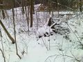
| − | Image: | + | Image:2010-01-16 48 11 woods.jpg|In this woods is the HP |
| − | Image: | + | Image:2010-01-16 48 11 xkcd.jpg|XKCD in the snow on GZ |
| + | Image:2010-01-16 48 11 hp.jpg|GPSr marks the HP | ||
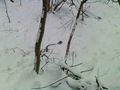
| + | Image:2010-01-16 48 11 wurzelstock.jpg|Tree remainings close to GZ | ||
</gallery> | </gallery> | ||
| Line 26: | Line 32: | ||
[[Category:Expeditions with photos]] | [[Category:Expeditions with photos]] | ||
[[Category:Coordinates reached]] | [[Category:Coordinates reached]] | ||
| + | {{location|DE|BY|EBE}} | ||
Latest revision as of 19:00, 18 January 2022
| Sat 16 Jan 2010 in Grafing: 48.0419401, 11.9914098 geohashing.info google osm bing/os kml crox |
About
East of Grafing in a little Forest.
Expeditions
Harleydavidsonandy
On this morning, I worked on speeding up my GSAK macro for GeoHashing on the newly released GSAK version beta 7.7. This took my a while, but the author finally gave me the needed hint, and my macro is now generating about 800 Hashpoints in seconds, what took several minutes before :-)). As a "reward" the DOW placed this HP pretty close to my home and it took me only about 45 minutes to drive there and going back again. I parked the car in 30m distance of the HP and zeroed it out. Marked the spot with a XKCD logo in the snow, took some photos and went back home. In the evening, I tried to explain what GeoHashing is to a friend of mine, but he couldn't understand why to visit a "random" point only to have been there...
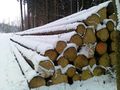
Pile of logs in the area
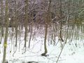
In this woods is the HP
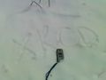
XKCD in the snow on GZ
GPSr marks the HP
Tree remainings close to GZ


