Difference between revisions of "2010-02-01 42 -88"
imported>Mrmoses (Created page with '{{subst:Expedition |lat = 42 |lon = -88 |date = 2010-02-01 }}') |
imported>FippeBot m (Location) |
||
| (6 intermediate revisions by 2 users not shown) | |||
| Line 1: | Line 1: | ||
| − | |||
<!-- If you did not specify these parameters in the template, please substitute appropriate things for IMAGE, LAT, LON, and DATE (YYYY-MM-DD format) | <!-- If you did not specify these parameters in the template, please substitute appropriate things for IMAGE, LAT, LON, and DATE (YYYY-MM-DD format) | ||
| Line 15: | Line 14: | ||
__NOTOC__ | __NOTOC__ | ||
== Location == | == Location == | ||
| − | + | On a street or front yard in a neighborhood near a lake. | |
== Participants == | == Participants == | ||
| − | + | *[[User:mrmoses|MrMoses]] | |
| + | *[[User:dleininger|DLeininger]] | ||
== Plans == | == Plans == | ||
| − | + | Leave right after work (5pm), drive through/by hashpoint and then go home. | |
== Expedition == | == Expedition == | ||
| − | + | As we got close, we saw a Dairy Queen, so we grabbed some slushies for the [[GeoSquishy|GeoSquishy achievement]]. We came to a fork in the road, the right side had an open gate and the left side didnt. I went left, which was the wrong way, so we backed up and went through the gate. | |
| − | == Tracklog == | + | As we passed through the gate, we noticed the No Trespassing sign, but since we already passed the gate, and the road was too narrow to turn around, and the hashpoint was just a few blocks ahead, we continued on. We passed the hashpoint, turned around in a driveway, took some pictures as we passed back by the hashpoint and then left (making sure to [http://www.youtube.com/watch?v=VXkICwMSnCk capture the No Trespassing sign]). |
| − | + | ||
| + | The DQ was 8.4 km, so we didn't get the [[GeoSquishy|GeoSquishy achievement]] :( | ||
| + | |||
| + | == [http://maps.google.com/maps/ms?hl=en&ie=UTF8&hq=&hnear=527+N+1st+St,+Rockford,+Winnebago,+Illinois+61107&msa=0&msid=109316342448012701002.00047e94c0eef92d1e718&t=h&z=11 Tracklog] == | ||
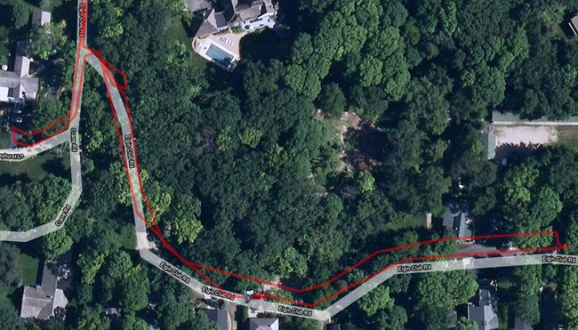
| + | Here is a screenshot of the tracklog near the hashpoint. Click the image to view the full track log. | ||
| + | [[File:2010-02-01 42 -88 tracklog.png|left|650px|link=http://maps.google.com/maps/ms?hl=en&ie=UTF8&hq=&hnear=527+N+1st+St,+Rockford,+Winnebago,+Illinois+61107&msa=0&msid=109316342448012701002.00047e94c0eef92d1e718&t=h&z=11]] | ||
| + | <br style="clear:both" /> | ||
== Photos == | == Photos == | ||
| + | [[User:dleininger|DLeininger]] has the photos... | ||
<!-- Insert pictures between the gallery tags using the following format: | <!-- Insert pictures between the gallery tags using the following format: | ||
<gallery perrow="4"> | <gallery perrow="4"> | ||
| Line 37: | Line 44: | ||
--> | --> | ||
| + | == [http://www.youtube.com/watch?v=VXkICwMSnCk Video] == | ||
| + | [http://www.youtube.com/watch?v=VXkICwMSnCk Leaving the geohash] (shows our slushies, location, and No Trespassing sign) | ||
| + | |||
| + | == Achievements == | ||
| + | {{consecutive geohash | ||
| + | | count = 2 | ||
| + | | latitude = 42| longitude = -88 | date = 2010-01-31 | ||
| + | | name = [[User:Mrmoses|MrMoses]] | ||
| + | }} | ||
| − | |||
| − | |||
| − | |||
| − | |||
| − | |||
| − | |||
| − | |||
| − | |||
[[Category:Expeditions]] | [[Category:Expeditions]] | ||
| − | |||
[[Category:Expeditions with photos]] | [[Category:Expeditions with photos]] | ||
| − | [[Category:Expeditions with videos]] | + | [[Category:Expeditions with videos]] |
| − | |||
| − | |||
| − | |||
| − | |||
[[Category:Coordinates reached]] | [[Category:Coordinates reached]] | ||
| − | + | {{location|US|WI|WL}} | |
| − | |||
| − | |||
| − | |||
| − | |||
| − | |||
| − | |||
| − | |||
| − | |||
| − | |||
Latest revision as of 00:41, 9 August 2019
| Mon 1 Feb 2010 in 42,-88: 42.5753114, -88.5009410 geohashing.info google osm bing/os kml crox |
Location
On a street or front yard in a neighborhood near a lake.
Participants
Plans
Leave right after work (5pm), drive through/by hashpoint and then go home.
Expedition
As we got close, we saw a Dairy Queen, so we grabbed some slushies for the GeoSquishy achievement. We came to a fork in the road, the right side had an open gate and the left side didnt. I went left, which was the wrong way, so we backed up and went through the gate.
As we passed through the gate, we noticed the No Trespassing sign, but since we already passed the gate, and the road was too narrow to turn around, and the hashpoint was just a few blocks ahead, we continued on. We passed the hashpoint, turned around in a driveway, took some pictures as we passed back by the hashpoint and then left (making sure to capture the No Trespassing sign).
The DQ was 8.4 km, so we didn't get the GeoSquishy achievement :(
Tracklog
Here is a screenshot of the tracklog near the hashpoint. Click the image to view the full track log.
Photos
DLeininger has the photos...
Video
Leaving the geohash (shows our slushies, location, and No Trespassing sign)
Achievements
MrMoses earned the Consecutive geohash achievement
|