Difference between revisions of "2010-02-04 45 -122"
imported>Michael5000 m (→Location) |
imported>FippeBot m (Location) |
||
| (13 intermediate revisions by 2 users not shown) | |||
| Line 1: | Line 1: | ||
| − | |||
{{meetup graticule | {{meetup graticule | ||
| lat=45 | | lat=45 | ||
| Line 13: | Line 12: | ||
== Participants == | == Participants == | ||
| − | + | ===Expedition one=== | |
| + | *[[User:Michael5000|Michael5000]] | ||
| + | *[[User:Mrs.5000|Mrs.5000]] | ||
| + | |||
| + | ===Expedition two === | ||
| + | *[[User:Jiml|Jim]] | ||
== Plans == | == Plans == | ||
| − | + | ===One=== | |
| + | It was a dark and stormy night. Michael5000 had had a crappy day at work. "The hash point is in Milwaukie," he told Mrs.5000. "Want to go get it?" "Oh, yes," she replied. | ||
| + | |||
| + | ===Two=== | ||
| + | I decided to go to the hashpoint in the evening. | ||
| + | I had some spare time between a couple of meetings to get information | ||
| + | onto my laptop and program the GPS. However, clearly not much planning happened, since I started out | ||
| + | with a pretty hungry cellphone and GPS and no spare batteries. Neither device survived all the way home. | ||
== Expedition == | == Expedition == | ||
| − | + | ===One=== | |
| + | We drove down 39th until we ran out of street, and then had to backtrack a long ways to get around the Johnson Creek corridor. Then we drove down Harrison Street, stopped at the hashpoint, and experienced the bliss of a successful hash. | ||
| − | == | + | ===Two=== |
| − | + | Jim drove across Portland and got somewhat close to the hashpoint, and then tried to extract | |
| + | useful directions from his cellphone. All I got was data that didn't make any sense to me. | ||
| + | I'm sure it was accurate, but the way it presents it makes no sense to my brain. | ||
| + | |||
| + | I got close to the hashpoint and turned on the GPS, hoping it would last. It did, and I found the | ||
| + | hashpoint. I took a picture, which is now stuck in the cell phone. Shortly thereafter, trying | ||
| + | to get directions home, the cellphone decided the battery was too low to talk to the radios any | ||
| + | more, and that was the end of it. The GPS lasted partway home, but I didn't need it to get home, | ||
| + | luckily. | ||
== Photos == | == Photos == | ||
| − | + | ||
<gallery perrow="4"> | <gallery perrow="4"> | ||
| − | Image: | + | Image:2010-02-04 Mrs.5000.jpg | Mrs.5000 at the hashpoint. |
| − | Image: | + | Image:2010-02-04 Truck.jpg | The truck in a no truck parking zone. Hmm... |
| + | Image:2010-02-04_45_-122-GPS.jpg | Proof picture from Jim | ||
</gallery> | </gallery> | ||
| − | |||
| − | + | {{land geohash | latitude = 45 | longitude = -122 | date = 2010-02-04 | name = The 5000's }} | |
| − | + | {{land geohash | latitude = 45 | longitude = -122 | date = 2010-02-04 | name = Jim }} | |
| − | + | ||
| − | |||
| − | |||
| − | |||
| − | |||
| − | |||
[[Category:Expeditions]] | [[Category:Expeditions]] | ||
| − | |||
[[Category:Expeditions with photos]] | [[Category:Expeditions with photos]] | ||
| − | |||
[[Category:Expedition without GPS]] | [[Category:Expedition without GPS]] | ||
| − | |||
| − | |||
| − | |||
[[Category:Coordinates reached]] | [[Category:Coordinates reached]] | ||
| − | + | {{location|US|OR|CC}} | |
| − | |||
| − | |||
| − | |||
| − | |||
| − | |||
| − | |||
| − | |||
| − | |||
| − | |||
Latest revision as of 00:44, 9 August 2019
| Thu 4 Feb 2010 in 45,-122: 45.4465739, -122.6178369 geohashing.info google osm bing/os kml crox |
Location
Across the street from the back of a Safeway in Milwaukie.
Participants
Expedition one
Expedition two
Plans
One
It was a dark and stormy night. Michael5000 had had a crappy day at work. "The hash point is in Milwaukie," he told Mrs.5000. "Want to go get it?" "Oh, yes," she replied.
Two
I decided to go to the hashpoint in the evening. I had some spare time between a couple of meetings to get information onto my laptop and program the GPS. However, clearly not much planning happened, since I started out with a pretty hungry cellphone and GPS and no spare batteries. Neither device survived all the way home.
Expedition
One
We drove down 39th until we ran out of street, and then had to backtrack a long ways to get around the Johnson Creek corridor. Then we drove down Harrison Street, stopped at the hashpoint, and experienced the bliss of a successful hash.
Two
Jim drove across Portland and got somewhat close to the hashpoint, and then tried to extract useful directions from his cellphone. All I got was data that didn't make any sense to me. I'm sure it was accurate, but the way it presents it makes no sense to my brain.
I got close to the hashpoint and turned on the GPS, hoping it would last. It did, and I found the hashpoint. I took a picture, which is now stuck in the cell phone. Shortly thereafter, trying to get directions home, the cellphone decided the battery was too low to talk to the radios any more, and that was the end of it. The GPS lasted partway home, but I didn't need it to get home, luckily.
Photos

Mrs.5000 at the hashpoint.

The truck in a no truck parking zone. Hmm...
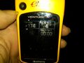
Proof picture from Jim


The 5000's earned the Land geohash achievement
|
Jim earned the Land geohash achievement
|