Difference between revisions of "2010-04-10 40 -86"
imported>Hat Guy |
imported>FippeBot m (Location) |
||
| (3 intermediate revisions by 2 users not shown) | |||
| Line 1: | Line 1: | ||
| − | |||
| − | |||
| − | |||
| − | |||
| − | |||
| − | |||
{{meetup graticule | {{meetup graticule | ||
| lat=40 | | lat=40 | ||
| Line 17: | Line 11: | ||
== Participants == | == Participants == | ||
| − | [[User:Hat Guy|Alex]] | + | *[[User:Hat Guy|Alex]] |
| − | [[User:Jessica|Jessi]] | + | *[[User:Jessica|Jessi]] |
== Plans == | == Plans == | ||
| Line 48: | Line 42: | ||
</gallery> | </gallery> | ||
| − | + | == Achievements Earned == | |
| − | + | {{land geohash | |
| − | + | | latitude = 40 | |
| + | | longitude = -86 | ||
| + | | date = 2010-04-10 | ||
| + | | name = [[User:Hat Guy|Alex]] and [[User:Jessica|Jessi]] | ||
| + | | image = | ||
| + | }} | ||
| + | {{Picnic_geohash | ||
| + | | latitude = 40 | ||
| + | | longitude = -86 | ||
| + | | date = 2010-04-10 | ||
| + | | name = [[User:Hat Guy|Alex]] and [[User:Jessica|Jessi]] | ||
| + | | image = | ||
| + | | food = triscuits and drunk pineapple | ||
| + | | bonus = | ||
| + | }} | ||
| Line 56: | Line 64: | ||
[[Category:Expeditions with photos]] | [[Category:Expeditions with photos]] | ||
[[Category:Coordinates reached]] | [[Category:Coordinates reached]] | ||
| − | + | {{location|US|IN|BO}} | |
| − | |||
| − | |||
| − | |||
| − | |||
| − | |||
| − | |||
| − | |||
| − | |||
| − | |||
| − | |||
| − | |||
| − | |||
| − | |||
| − | |||
| − | |||
| − | |||
| − | |||
| − | |||
| − | |||
| − | |||
| − | |||
Latest revision as of 03:10, 6 August 2019
| Sat 10 Apr 2010 in 40,-86: 40.1513277, -86.6384178 geohashing.info google osm bing/os kml crox |
Location
A field (corn) just northwest of Thorntown
Participants
Plans
Alex will almost certainly be there at 4:00 with Jessi
Expedition
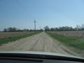
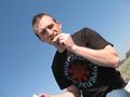
We set out to make the hash point around 3:30. According to Google, we had about an hour drive ahead of us, so we made sure that we had some sweet tunes for the trip. We ran into a detour about halfway, and while I was yelling at Jessi to slow down so I could get a picture of the sign, we missed the turn. People looked at us like we were crazy. After a bit more driving we turned off the main highway and were soon driving on gravel roads back to the field containing the hash.
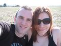
When we arrived, we walked out to the point and, after setting up our picnic blanket, took the necessary photographs. We enjoyed some triscuits and vodka-soaked pineapple before leaving. On the way back, we stopped to say hello to some horses and to play on a tree that was falling over. All in all, it was a pretty successful first expedition.
Photos
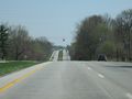
On the way
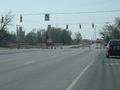
Oh noes!
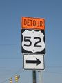
Notice how it says turn right? We didn't.
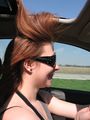
The sunroof was hungry
Almost there!
Aww...
This was a hard picture to get..it was sunny
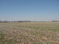
This is the only place in Indiana like this
Om nom nom
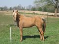
horsey!
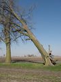
Timber...(in slow motion)
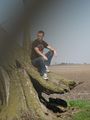
The foreboding shadow attacks!


Achievements Earned
Alex and Jessi earned the Land geohash achievement
|
Alex and Jessi earned the Picnic achievement
|