Difference between revisions of "2010-04-25 59 10"
imported>Relet (+photos) |
m (2020-01-01 update) |
||
| (6 intermediate revisions by 2 users not shown) | |||
| Line 1: | Line 1: | ||
| − | |||
| − | |||
| − | |||
| − | |||
| − | |||
| − | |||
{{meetup graticule | {{meetup graticule | ||
| lat=59 | | lat=59 | ||
| Line 11: | Line 5: | ||
}} | }} | ||
| − | |||
__NOTOC__ | __NOTOC__ | ||
== Location == | == Location == | ||
| − | + | Vikersund, Norway. Then up the hills. | |
| + | |||
| + | {{PBGH battleship | lat = 59 | lon = 10 | date = 2010-04-25 }} | ||
== Participants == | == Participants == | ||
| − | < | + | * [[User:relet|relet]] |
| + | |||
| + | == <s>Plans</s> == | ||
| − | + | Cycled 40km. Hiked 6-8km through (mostly) snow. Cycled back. | |
| − | |||
== Expedition == | == Expedition == | ||
| − | |||
| − | |||
| − | |||
*I don't know if I will get far, but here we go, Trusty and me. -- [[User:relet|relet]] [http://www.openstreetmap.org/?lat=60.14846742153168&lon=10.268542170524597&zoom=16&layers=B000FTF @60.1485,10.2685] 10:47, 25 April 2010 (MESZ) | *I don't know if I will get far, but here we go, Trusty and me. -- [[User:relet|relet]] [http://www.openstreetmap.org/?lat=60.14846742153168&lon=10.268542170524597&zoom=16&layers=B000FTF @60.1485,10.2685] 10:47, 25 April 2010 (MESZ) | ||
| Line 50: | Line 43: | ||
File:2010-04-25-59-10-P1050962.JPG | Reached Vikersund. They have boats. | File:2010-04-25-59-10-P1050962.JPG | Reached Vikersund. They have boats. | ||
File:2010-04-25-59-10-P1050963.JPG | This could be a scenic holiday location, if it wasn't situated next to the main bridge. | File:2010-04-25-59-10-P1050963.JPG | This could be a scenic holiday location, if it wasn't situated next to the main bridge. | ||
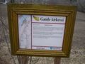
| − | File:2010-04-25-59-10-P1050965.JPG | There is an old | + | File:2010-04-25-59-10-P1050965.JPG | There is an "old church road" apparently. |
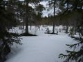
File:2010-04-25-59-10-P1050966.JPG | The track I chose up the mountain changed from "patches of snow" to this. | File:2010-04-25-59-10-P1050966.JPG | The track I chose up the mountain changed from "patches of snow" to this. | ||
File:2010-04-25-59-10-P1050967.JPG | I was following someone's footsteps most of the time. At least I knew where I would be about to break in. | File:2010-04-25-59-10-P1050967.JPG | I was following someone's footsteps most of the time. At least I knew where I would be about to break in. | ||
| Line 57: | Line 50: | ||
File:2010-04-25-59-10-P1050969.JPG | It didn't even look very locked. | File:2010-04-25-59-10-P1050969.JPG | It didn't even look very locked. | ||
File:2010-04-25-59-10-P1050970.JPG | I has a view. | File:2010-04-25-59-10-P1050970.JPG | I has a view. | ||
| − | File:2010-04-25-59-10-P1050971.JPG | And some [http://kart.statkart.no | + | File:2010-04-25-59-10-P1050971.JPG | And some [http://kart.statkart.no excellent maps] on my android. If only the skidoo drivers would stick to the unmarked paths hidden under the snow. |
File:2010-04-25-59-10-P1050972.JPG | The ants were rather busy already. | File:2010-04-25-59-10-P1050972.JPG | The ants were rather busy already. | ||
File:2010-04-25-59-10-P1050973.JPG | According to my map, this is a lake/swamp. | File:2010-04-25-59-10-P1050973.JPG | According to my map, this is a lake/swamp. | ||
| Line 79: | Line 72: | ||
[[Category:Expeditions with photos]] | [[Category:Expeditions with photos]] | ||
[[Category:Coordinates reached]] | [[Category:Coordinates reached]] | ||
| + | {{location|NO|30}} | ||
Latest revision as of 00:25, 16 February 2020
| Sun 25 Apr 2010 in 59,10: 59.9440030, 10.0453958 geohashing.info google osm bing/os kml crox |
Location
Vikersund, Norway. Then up the hills.
Today's battleship location is: A 10
Participants
Plans
Cycled 40km. Hiked 6-8km through (mostly) snow. Cycled back.
Expedition
- I don't know if I will get far, but here we go, Trusty and me. -- relet @60.1485,10.2685 10:47, 25 April 2010 (MESZ)
- With the fruit trees and the church bells ringing, I feel like in my grandma's village. -- relet @60.1485,10.2685 10:58, 25 April 2010 (MESZ)
- Until here, this was all just a detour, to avoid the highway bridge, which is closed for cyclists. -- relet @60.1485,10.2685 11:16, 25 April 2010 (MESZ)
- I could cycle alongside fjords all day long. In fact, that's what I am going to do. Yay! -- relet @60.1485,10.2685 11:30, 25 April 2010 (MESZ)
- Reached Vikersund and started walking. The rule of the game today is obviously to keep dry shoes. And don't talk about geohashing! -- relet @59.9506,10.0151 13:59, 25 April 2010 (MESZ)
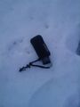
- Coordinates reached. No reception at hashpoint. Lost and found my camera. Broke both rules. Ducking tired. Time to think about the return trip. -- relet @59.9371,10.0369 16:30, 25 April 2010 (MESZ)
- As usual, the return path is so much less complicated. And this canyon is amazing. -- relet @59.9415,10.0078 17:04, 25 April 2010 (MESZ)
- According to recent statistics, there are only slightly fewer trees than elk droppings. -- relet @59.9415,10.0078 17:09, 25 April 2010 (MESZ)
- I made it home, apparently. -- relet 20:07, 25 April 2010 (MESZ)
Photos
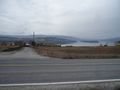
Everyone should have a fjord. Even Africa! The weather is a bit rainy though.
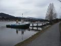
Reached Vikersund. They have boats.
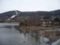
This could be a scenic holiday location, if it wasn't situated next to the main bridge.
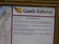
There is an "old church road" apparently.
The track I chose up the mountain changed from "patches of snow" to this.
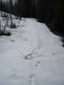
I was following someone's footsteps most of the time. At least I knew where I would be about to break in.
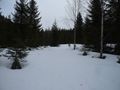
And then, a road!
They're taunting me! Or is tempting the right word? @59.9000,9.9098
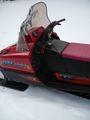
It didn't even look very locked.
I has a view.
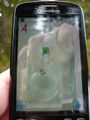
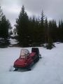
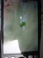
And some excellent maps on my android. If only the skidoo drivers would stick to the unmarked paths hidden under the snow.
The ants were rather busy already.
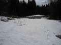
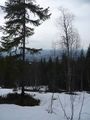
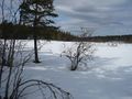
According to my map, this is a lake/swamp.
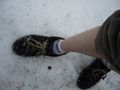
The best snowshoes money can buy. Truuuuust me. (But frankly, the wide soles did not fare so bad.)
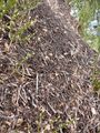
More antsy goodness.
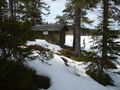
A geohut! That was unexpected!
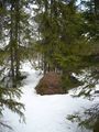
You can tell it wants to become a lake again.

Coordinates reached!
RMaps agrees.

Happy tired geohasher.
Not a good idea.
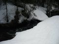
On the way back - a canyon.
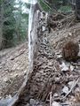
I like this tree stump.
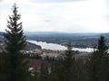
I has more view.
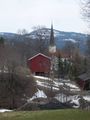
I came out pretty close to the old church.
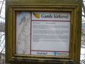
More history.
More history.


