Difference between revisions of "2010-05-29 60 10"
From Geohashing
imported>Relet m (→Location) |
m (2020-01-01 update) |
||
| (2 intermediate revisions by 2 users not shown) | |||
| Line 1: | Line 1: | ||
| − | |||
| − | |||
| − | |||
| − | |||
| − | |||
| − | |||
| − | |||
{{meetup graticule | {{meetup graticule | ||
| lat=60 | | lat=60 | ||
| Line 12: | Line 5: | ||
}} | }} | ||
| − | + | ||
__NOTOC__ | __NOTOC__ | ||
== Location == | == Location == | ||
| Line 20: | Line 13: | ||
== Participants == | == Participants == | ||
| − | + | * [[User:relet|relet]] | |
== Plans == | == Plans == | ||
| Line 45: | Line 38: | ||
| − | |||
| − | |||
| − | |||
| − | + | [[Category:Expeditions]] | |
| − | |||
| − | [[Category: | ||
| − | |||
| − | |||
| − | |||
| − | |||
[[Category:Expeditions with photos]] | [[Category:Expeditions with photos]] | ||
| − | |||
| − | |||
| − | |||
| − | |||
| − | |||
[[Category:Coordinates reached]] | [[Category:Coordinates reached]] | ||
| − | + | {{location|NO|30}} | |
| − | |||
| − | |||
| − | |||
| − | |||
| − | |||
| − | |||
| − | |||
| − | |||
| − | |||
Latest revision as of 00:26, 16 February 2020
| Sat 29 May 2010 in 60,10: 60.1849007, 10.2697917 geohashing.info google osm bing/os kml crox |
Location
Hønengata in Hønefoss (or maybe just on Ådalsveien already)
Today's battleship location is: C 2
Participants
Plans
Expedition
- A quick dash'n hash. Coordinates reached. It's a road. -- relet @60.1849,10.2701 19:56, 29 Mai 2010 (GMT+02:00)
Tracklog
Photos
Houses lyx asked me to prove that they weren't built yet.
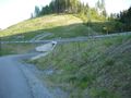
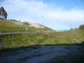
The hash is actually right next to the guardrail.
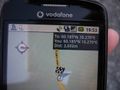
Proof.


