Difference between revisions of "2010-06-06 52 13"
imported>Ilpadre m (→ilpadre) |
imported>FippeBot m (Location) |
||
| (9 intermediate revisions by 4 users not shown) | |||
| Line 22: | Line 22: | ||
=== davidc === | === davidc === | ||
| + | |||
| + | (A rather delayed report, very busy month!) | ||
| + | |||
| + | Well, this was a curious one. The satellite image on maps.google.com shows it just inside the western building; the satellite image on my iPhone showed it at the corner of the eastern building. I also have the weird situation of the map GPS being within the circle of inaccuracy and the Motion-X GPS app screenshot I took being outside. However given that I wandered around both parking lots, I am confident I was within official GPS inaccuracy consideration at some point. | ||
=== ilpadre === | === ilpadre === | ||
| − | See [[2010-06-05 52 13]]. | + | See [[2010-06-05 52 13]]. Even though I walked up to the wall of the house, it were still a few meters to go, so I'll live with "not reached". (Even if davidc found the coordinates outside the house, I was still unsuccessful, since I left before midnight.) |
== Tracklog == | == Tracklog == | ||
=== ilpadre === | === ilpadre === | ||
| + | |||
| + | http://www.everytrail.com/view_trip.php?trip_id=656773 | ||
== Photos == | == Photos == | ||
| Line 36: | Line 42: | ||
<gallery> | <gallery> | ||
| + | File:2010-06-06 52 13 ilpadre feuerbachstr.jpg | ||
| + | File:2010-06-06 52 13 ilpadre feuerbachstr WITH SCIENCE.jpg | ||
| + | File:2010-06-06 52 13 ilpadre hashpoint.jpg|Inside that house | ||
| + | File:2010-06-06 52 13 ilpadre adlershof laser.jpg|Back in Adlershof | ||
</gallery> | </gallery> | ||
| + | === davidc === | ||
| + | |||
| + | <gallery> | ||
| + | File:2010-06-06_52_13_IMG_0310.PNG|iPhone map proof, of sorts. | ||
| + | File:2010-06-06_52_13_IMG_0312.PNG|GPS proof, of sorts. | ||
| + | File:2010-06-06_52_13_IMG_2223.JPG|Newfangled heat has wilted our grins. | ||
| + | File:2010-06-06_52_13_IMG_2225.JPG|Potential hashpoint A. | ||
| + | File:2010-06-06_52_13_IMG_2227.JPG|Potential hashpoint B. | ||
| + | File:2010-06-06_52_13_IMG_2228.JPG|Potential hashpoint A from another angle. | ||
| + | File:2010-06-06_52_13_IMG_2230.JPG|A nice tree-lined street for the hash. | ||
| + | File:2010-06-06_52_13_IMG_2236.JPG|Rabbitfox finds the rose geocache. | ||
| + | File:2010-06-06_52_13_IMG_2240.JPG|A funny way to adhere to building code - Edeka's carpark, with the facade of the original building left intact (there was a geocache here). | ||
| + | </gallery> | ||
| − | [[Category:Coordinates | + | [[Category:Coordinates reached]] |
| − | [[Category: | + | [[Category:Expeditions]] |
| − | [[Category: | + | [[Category:Expeditions with photos]] |
| + | {{location|DE|BE}} | ||
Latest revision as of 02:20, 9 August 2019
| Sun 6 Jun 2010 in 52,13: 52.4635608, 13.3294087 geohashing.info google osm bing/os kml crox |
Location
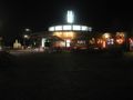
Feuerbachstraße, Steglitz
Participants
Plans
- Heading there now, will be geocaching in the area. --davidc 13:47, 6 June 2010 (UTC)
Expedition
davidc
(A rather delayed report, very busy month!)
Well, this was a curious one. The satellite image on maps.google.com shows it just inside the western building; the satellite image on my iPhone showed it at the corner of the eastern building. I also have the weird situation of the map GPS being within the circle of inaccuracy and the Motion-X GPS app screenshot I took being outside. However given that I wandered around both parking lots, I am confident I was within official GPS inaccuracy consideration at some point.
ilpadre
See 2010-06-05 52 13. Even though I walked up to the wall of the house, it were still a few meters to go, so I'll live with "not reached". (Even if davidc found the coordinates outside the house, I was still unsuccessful, since I left before midnight.)
Tracklog
ilpadre
http://www.everytrail.com/view_trip.php?trip_id=656773
Photos
ilpadre
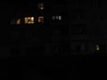
Inside that house
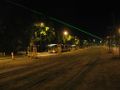
Back in Adlershof


davidc
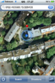
iPhone map proof, of sorts.
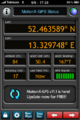
GPS proof, of sorts.

Newfangled heat has wilted our grins.
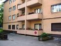
Potential hashpoint A.
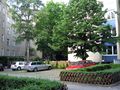
Potential hashpoint B.
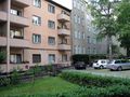
Potential hashpoint A from another angle.
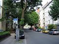
A nice tree-lined street for the hash.

Rabbitfox finds the rose geocache.
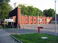
A funny way to adhere to building code - Edeka's carpark, with the facade of the original building left intact (there was a geocache here).


