Difference between revisions of "2010-08-12 42 -123"
imported>Michael5000 (→Photos) |
imported>FippeBot m (Location) |
||
| (One intermediate revision by one other user not shown) | |||
| Line 26: | Line 26: | ||
File:2010-08-12 42 -123 Meet the 5000s.jpg|Meet the 5000s! | File:2010-08-12 42 -123 Meet the 5000s.jpg|Meet the 5000s! | ||
File:2010-08-12 42 -123 Road.jpg|The long and winding road. | File:2010-08-12 42 -123 Road.jpg|The long and winding road. | ||
| − | File:2010-08-12 42 -123 Terrain.jpg| | + | File:2010-08-12 42 -123 Terrain.jpg|Much of Southern Oregon is at a bit of a tilt. |
File:2010-08-12 42 -123 Michael5000.jpg|Michael5000 looks down at Mrs.5000. | File:2010-08-12 42 -123 Michael5000.jpg|Michael5000 looks down at Mrs.5000. | ||
File:2010-08-12 42 -123 Mrs5000.jpg|Mrs.5000 looks up at Michael5000. | File:2010-08-12 42 -123 Mrs5000.jpg|Mrs.5000 looks up at Michael5000. | ||
| Line 35: | Line 35: | ||
[[Category:Expeditions with photos]] | [[Category:Expeditions with photos]] | ||
[[Category:Coordinates reached]] | [[Category:Coordinates reached]] | ||
| + | {{location|US|OR|JA}} | ||
Latest revision as of 03:15, 9 August 2019
| Thu 12 Aug 2010 in 42,-123: 42.2326602, -123.2127346 geohashing.info google osm bing/os kml crox |
Location
In the hills south of the Applegate Valley.
Participants
Expedition
On the way south on I-5, we took a side loop down Oregon 238 through the lovely Applegate Valley. Ferris Gulch Road was a one-lane BLM Road, well-maintained but with no traffic whatsoever. It wound steeply uphill about three miles to a point about 120 feet from the hashpoint.
We found a safe place to park, and Michael5000 scrambled up the embankment saying words every wife loves to hear her husband say: "I have no idea how I'll get back down from here...." Once at the hashpoint -- a site marked by two large trees -- we were able to figure out a more sane route for Mrs.5000 to make it upslope, and for us both to get back down safely. Expedition Succeeded!
Photos

Meet the 5000s!
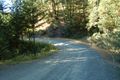
The long and winding road.
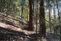
Much of Southern Oregon is at a bit of a tilt.

Michael5000 looks down at Mrs.5000.

Mrs.5000 looks up at Michael5000.


