Difference between revisions of "2010-09-18 66 25"
imported>Isopekka (→Photos) |
imported>FippeBot m (Location) |
||
| (5 intermediate revisions by 2 users not shown) | |||
| Line 1: | Line 1: | ||
<!-- If you did not specify these parameters in the template, please substitute appropriate things for IMAGE, LAT, LON, and DATE (YYYY-MM-DD format) | <!-- If you did not specify these parameters in the template, please substitute appropriate things for IMAGE, LAT, LON, and DATE (YYYY-MM-DD format) | ||
| − | |||
Remove this section if you don't want a image at the top (left) of your report. You should remove the "Image:" or "File:" | Remove this section if you don't want a image at the top (left) of your report. You should remove the "Image:" or "File:" | ||
| Line 8: | Line 7: | ||
And DON'T FORGET to add your expedition and the best photo you took to the gallery on the Main Page! We'd love to read your report, but that means we first have to discover it! | And DON'T FORGET to add your expedition and the best photo you took to the gallery on the Main Page! We'd love to read your report, but that means we first have to discover it! | ||
--> | --> | ||
| + | |||
| + | [[Image:Geohäsläys6 011.JPG|thumb|left]] | ||
| + | |||
{{meetup graticule | {{meetup graticule | ||
| lat=66 | | lat=66 | ||
| Line 39: | Line 41: | ||
* Expedition took 2 hours | * Expedition took 2 hours | ||
* Physical efforts needed(1-5): 2 | * Physical efforts needed(1-5): 2 | ||
| + | |||
==Photos == | ==Photos == | ||
| Line 44: | Line 47: | ||
<Gallery> | <Gallery> | ||
| − | Image:Gh6sat.jpg| Below the hashpoint you can see the triangular training area for hunters to | + | Image:Gh6sat.jpg| Below the hashpoint you can see the triangular training area for hunters to practise shooting |
Image:Geohäsläys6 001.JPG| To the area, where you can practise shooting... | Image:Geohäsläys6 001.JPG| To the area, where you can practise shooting... | ||
Image:Geohäsläys6 002.JPG | Oops, 1 km to walk! | Image:Geohäsläys6 002.JPG | Oops, 1 km to walk! | ||
| Line 56: | Line 59: | ||
</Gallery> | </Gallery> | ||
| + | |||
== Achievements == | == Achievements == | ||
| + | {{land geohash | ||
| + | | latitude = 66 | ||
| + | | longitude = 25 | ||
| + | | date = 2010-09-18 | ||
| + | | name = isopekka | ||
| + | |||
| + | }} | ||
| + | == Other Geohashing Expeditions and Plans on This Day == | ||
| − | + | {{expedition summaries|2010-09-18}} | |
| − | |||
| − | |||
| − | |||
| − | |||
| − | |||
| − | |||
| − | |||
| Line 77: | Line 82: | ||
[[Category:Expeditions with photos]] | [[Category:Expeditions with photos]] | ||
[[Category:Coordinates reached]] | [[Category:Coordinates reached]] | ||
| + | {{location|FI|10}} | ||
Latest revision as of 03:47, 9 August 2019

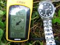
| Sat 18 Sep 2010 in 66,25: 66.4477529, 25.3978725 geohashing.info google osm bing/os kml crox |
Contents
Location
About 15 km W from the city of Rovaniemi, Finland. Near the shooting area for hunters to practise.
Participants
- isopekka & dog
Expedition
I took my dog to the car and started my expedition. On the way I saw two mooses to run across the road, but unfortunately could not take a photo. At the hashpoint we were 14:30 pm. Nothing special happened, I did not meet anyone in the forest.
- By car total 47 km
- Walking total 2 km
- Expedition took 2 hours
- Physical efforts needed(1-5): 2
Photos
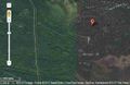
Below the hashpoint you can see the triangular training area for hunters to practise shooting
To the area, where you can practise shooting...
Oops, 1 km to walk!
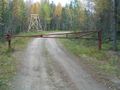
Hashpoint locates 200 meters behind this construction. No hunters here today. Fine!
At the hash
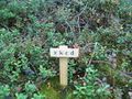
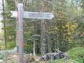
Hashpoint marked with wooden marker plate
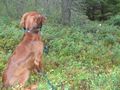
My setter guarding the new hashpoint marker
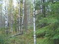
Autumn around the hashpoint
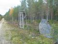
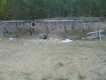
Hunt a moose: wait here and shoot!


Achievements
isopekka earned the Land geohash achievement
|
Other Geohashing Expeditions and Plans on This Day
Expeditions and Plans
| 2010-09-18 | ||
|---|---|---|
| Newark, New Jersey | Someone went | Behind Papa John's on NJ-18 in East Brunswick, just past Ferris St. |
| Norwich, United Kingdom | Sourcerer | About 3 km west of Bungay, Suffolk,UK. |
| Rovaniemi, Finland | isopekka | About 15 km W from the city of Rovaniemi, Finland. Near the shooting area f... |