Difference between revisions of "2010-10-07 -37 174"
imported>Greenslime m (Created page with '{{subst:Expedition |lat = -37 |lon = 174 |date = 2010-10-07 }}') |
imported>FippeBot m (Location) |
||
| (11 intermediate revisions by 2 users not shown) | |||
| Line 1: | Line 1: | ||
| − | |||
| − | |||
| − | |||
| − | |||
| − | |||
| − | |||
| − | |||
| − | |||
| − | |||
| − | |||
{{meetup graticule | {{meetup graticule | ||
| lat=-37 | | lat=-37 | ||
| Line 15: | Line 5: | ||
}} | }} | ||
| − | + | ||
__NOTOC__ | __NOTOC__ | ||
== Location == | == Location == | ||
| − | + | ||
| + | On a west coast beach | ||
== Participants == | == Participants == | ||
| − | + | [[User:Greenslime|Greenslime]] | |
== Plans == | == Plans == | ||
| − | + | Damn this cool hash landing on a week day. | |
| + | |||
| + | This would be the ideal weekend mission, big drive out to Whatipu beach, and a long meander up the beach. The hash is actually near the end of two track so access shouldn't be a problem. | ||
| + | I will assess my workload at lunch time today, and consider nipping out. | ||
| + | |||
| + | Life's too short to pass up good hashes like this! | ||
== Expedition == | == Expedition == | ||
| − | + | Of course I couldn't pass this one up, but am I annoyed that I was so under-prepared for it. | |
| + | |||
| + | I ended up coming in from the north east utilising the Buck Taylor track, to avoid an arduous meander up the sand from Whatipu in the south. | ||
| + | |||
| + | I had intended for this to be a trail run so I packed light, with running shoes and no gaiters (mistake one and two). It was an amazing run down - down being the word, and im thinking about how much up there will be getting out - deal with that later. I arrived on the beach, and there was infact a river separating me by 70 m to the hash... Now ive been here before, and I knew there was this river - I even know its name - Pararaha - and I remember how swampy it was, and indeed, it was still very swampy. (mistake three, forgetting the terrain) | ||
| + | |||
| + | Okay, i have some time (well I didn't really but I made some) so I ran back inland to the reentrant where the river flows down to find a crossable section, intending to get on to the ridge. River crossing was okay, knee deep water, and now I have to make my way back around the toe of the ridge. This task seemed doable - while I was looking at it from the other side of the river (mistake four - not bringing a topo map) - and it was easy going for the first bit as there was a bait trail leading along it. After awhile that petered out and I was left bush bashing on an every increasing slope. Oh and the gorse, the gorse ripped me apart, im sure there will be scars. I got within 80 m to the hash and called it a day, I could tell that the hash was a bit further along and below me on the slope, but i had gained too much height on my traverse and there were rock faces that needed to be navigated. By this stage i've had enough of the gorse and was starting to have mental images about falling. I made it back to the river where I was initially thwarted and seriously considered swimming across had it not been for the fact I didn't have a proper plastic bag for my camera :( I really didn't want to let it go, my kingdom for a boat, or cliffs of despair - take your pick. | ||
| + | |||
| + | The run back up almost killed me. | ||
== Tracklog == | == Tracklog == | ||
| Line 33: | Line 37: | ||
== Photos == | == Photos == | ||
| − | |||
| − | |||
| − | |||
<gallery perrow="5"> | <gallery perrow="5"> | ||
| + | File:2010-10-07 -37 174 In the distance.jpg|Hash in the distance, at the bottom of the ridge, note: river | ||
| + | File:2010-10-07 -37 174 Come from there.jpg|Just come from that ridge, deal with that ascent later | ||
| + | File:2010-10-07 -37 174 Hatching a plan.jpg|Hash is behind me 70 m, hatching a plan | ||
| + | File:2010-10-07 -37 174 From that river.jpg|Followed the river up and onto this ridge | ||
| + | File:2010-10-07 -37 174 Around that toe.jpg|Its just around that toe, honest | ||
| + | File:2010-10-07 -37 174 Other side of the river.jpg|Hash a little further on and below me. Perhaps if i had ropes | ||
| + | File:2010-10-07 -37 174 At the end.jpg|Me, at the end, all run out | ||
| + | | ||
</gallery> | </gallery> | ||
| Line 42: | Line 51: | ||
{{#vardefine:ribbonwidth|800px}} | {{#vardefine:ribbonwidth|800px}} | ||
<!-- Add any achievement ribbons you earned below, or remove this section --> | <!-- Add any achievement ribbons you earned below, or remove this section --> | ||
| + | {{My kingdom for a boat | ||
| + | | latitude = -37 | ||
| + | | longitude = 174 | ||
| + | | date = 2010-10-07 | ||
| + | | name = Greenslime | ||
| + | | waterhazard = Pararaha River | ||
| + | }} | ||
| + | or | ||
| + | {{Cliffs of Despair | ||
| + | | latitude = -37 | ||
| + | | longitude = 174 | ||
| + | | date = 2010-10-07 | ||
| + | | name = Greenslime | ||
| + | | terrain = steep ridge face | ||
| + | }} | ||
| − | |||
| − | |||
| − | |||
| − | |||
| − | |||
| − | |||
| − | |||
| − | |||
| − | |||
| − | |||
| − | |||
[[Category:Expeditions]] | [[Category:Expeditions]] | ||
| − | |||
[[Category:Expeditions with photos]] | [[Category:Expeditions with photos]] | ||
| − | |||
| − | |||
| − | |||
| − | |||
| − | |||
| − | |||
| − | |||
| − | |||
| − | |||
[[Category:Coordinates not reached]] | [[Category:Coordinates not reached]] | ||
| − | + | [[Category:Not reached - Mother Nature]] | |
| − | [[Category:Not reached - Mother Nature]] | + | {{location|NZ|AUK}} |
| − | |||
| − | |||
| − | |||
| − | |||
Latest revision as of 04:03, 9 August 2019
| Thu 7 Oct 2010 in -37,174: -37.0117018, 174.4863319 geohashing.info google osm bing/os kml crox |
Location
On a west coast beach
Participants
Plans
Damn this cool hash landing on a week day.
This would be the ideal weekend mission, big drive out to Whatipu beach, and a long meander up the beach. The hash is actually near the end of two track so access shouldn't be a problem. I will assess my workload at lunch time today, and consider nipping out.
Life's too short to pass up good hashes like this!
Expedition
Of course I couldn't pass this one up, but am I annoyed that I was so under-prepared for it.
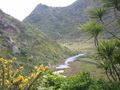
I ended up coming in from the north east utilising the Buck Taylor track, to avoid an arduous meander up the sand from Whatipu in the south.
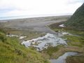
I had intended for this to be a trail run so I packed light, with running shoes and no gaiters (mistake one and two). It was an amazing run down - down being the word, and im thinking about how much up there will be getting out - deal with that later. I arrived on the beach, and there was infact a river separating me by 70 m to the hash... Now ive been here before, and I knew there was this river - I even know its name - Pararaha - and I remember how swampy it was, and indeed, it was still very swampy. (mistake three, forgetting the terrain)
Okay, i have some time (well I didn't really but I made some) so I ran back inland to the reentrant where the river flows down to find a crossable section, intending to get on to the ridge. River crossing was okay, knee deep water, and now I have to make my way back around the toe of the ridge. This task seemed doable - while I was looking at it from the other side of the river (mistake four - not bringing a topo map) - and it was easy going for the first bit as there was a bait trail leading along it. After awhile that petered out and I was left bush bashing on an every increasing slope. Oh and the gorse, the gorse ripped me apart, im sure there will be scars. I got within 80 m to the hash and called it a day, I could tell that the hash was a bit further along and below me on the slope, but i had gained too much height on my traverse and there were rock faces that needed to be navigated. By this stage i've had enough of the gorse and was starting to have mental images about falling. I made it back to the river where I was initially thwarted and seriously considered swimming across had it not been for the fact I didn't have a proper plastic bag for my camera :( I really didn't want to let it go, my kingdom for a boat, or cliffs of despair - take your pick.
The run back up almost killed me.
Tracklog
Photos
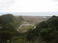
Hash in the distance, at the bottom of the ridge, note: river
Just come from that ridge, deal with that ascent later
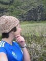
Hash is behind me 70 m, hatching a plan
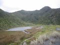
Followed the river up and onto this ridge
Its just around that toe, honest
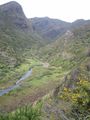
Hash a little further on and below me. Perhaps if i had ropes

Me, at the end, all run out


Achievements
Greenslime earned the My kingdom for a boat consolation prize
|
or
Greenslime earned the Cliffs of Despair consolation prize
|