Difference between revisions of "2010-10-07 45 -122"
imported>Jiml m (Fill in details) |
imported>FippeBot m (Location) |
||
| (5 intermediate revisions by 2 users not shown) | |||
| Line 1: | Line 1: | ||
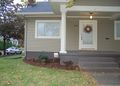
| − | + | [[File:2010-10-07 45 -122 House.jpg|thumb|left|300px|The house at the hashpoint.]] | |
| − | |||
| − | |||
| − | |||
| − | |||
| − | |||
{{meetup graticule | {{meetup graticule | ||
| lat=45 | | lat=45 | ||
| Line 17: | Line 12: | ||
__NOTOC__ | __NOTOC__ | ||
== Location == | == Location == | ||
| − | + | ||
| − | + | In a front lawn on a residential street in Northeast Portland | |
== Participants == | == Participants == | ||
| − | |||
* [[User:Jiml|Jim]] | * [[User:Jiml|Jim]] | ||
| + | * [[User:Michael5000|Michael5000]] | ||
| + | * [[User:Mrs.5000|Mrs.5000]] | ||
== Plans == | == Plans == | ||
| − | + | ||
| − | I'll go by and see how close I can get. | + | I'll go by and see how close I can get. I printed out the Google maps, and attempted to program |
| + | the GPS in the dark as I walked to the car. | ||
== Expedition == | == Expedition == | ||
| − | |||
| − | == | + | ===Jim=== |
| − | + | ||
| + | Well, I finally finished up the work I was doing with folks in Asia, and headed off to the | ||
| + | hashpoint. The directions from Google Maps didn't match the roadways very | ||
| + | well, so I gave up and just took Hwy 30 aways and then turned when the GPS told me to | ||
| + | go to the right. (I did remember I needed 15th street.) | ||
| + | |||
| + | I got close and parked and proceeded on foot. I was within 10 meters from the | ||
| + | sidewalk, but I tried walking up the walkway and I got a bit closer, but I didn't want | ||
| + | to trample the front lawn. | ||
| + | |||
| + | More details and photos will follow. | ||
| + | |||
| + | ===The 5000s=== | ||
| + | |||
| + | After work, we drove to 15th and Shaver. We walked up, took a picture, and then went out for Ethiopian food at the Blue Nile. Not every Expedition has to be an amazing adventure! | ||
== Photos == | == Photos == | ||
| + | Need to be uploaded | ||
<!-- Insert pictures between the gallery tags using the following format: | <!-- Insert pictures between the gallery tags using the following format: | ||
Image:2010-##-## ## ## Alpha.jpg | Witty Comment | Image:2010-##-## ## ## Alpha.jpg | Witty Comment | ||
--> | --> | ||
<gallery perrow="5"> | <gallery perrow="5"> | ||
| + | File:2010-10-07 45 -122 House.jpg | The Hashpoint is pretty much at that security sign. | ||
| + | File:2010-10-07 45 -122 Mrs5000.jpg | Mrs.5000 is amused. | ||
</gallery> | </gallery> | ||
== Achievements == | == Achievements == | ||
{{#vardefine:ribbonwidth|800px}} | {{#vardefine:ribbonwidth|800px}} | ||
| − | |||
| − | |||
| + | * Land Geohash | ||
| − | |||
| − | |||
[[Category:Expeditions]] | [[Category:Expeditions]] | ||
| − | |||
[[Category:Expeditions with photos]] | [[Category:Expeditions with photos]] | ||
| − | |||
| − | |||
| − | |||
| − | |||
| − | |||
[[Category:Coordinates reached]] | [[Category:Coordinates reached]] | ||
| − | + | {{location|US|OR|MU}} | |
| − | |||
| − | |||
| − | |||
| − | |||
| − | |||
| − | |||
| − | |||
| − | |||
| − | |||
Latest revision as of 04:04, 9 August 2019

| Thu 7 Oct 2010 in 45,-122: 45.5517399, -122.6501858 geohashing.info google osm bing/os kml crox |
Location
In a front lawn on a residential street in Northeast Portland
Participants
Plans
I'll go by and see how close I can get. I printed out the Google maps, and attempted to program the GPS in the dark as I walked to the car.
Expedition
Jim
Well, I finally finished up the work I was doing with folks in Asia, and headed off to the hashpoint. The directions from Google Maps didn't match the roadways very well, so I gave up and just took Hwy 30 aways and then turned when the GPS told me to go to the right. (I did remember I needed 15th street.)
I got close and parked and proceeded on foot. I was within 10 meters from the sidewalk, but I tried walking up the walkway and I got a bit closer, but I didn't want to trample the front lawn.
More details and photos will follow.
The 5000s
After work, we drove to 15th and Shaver. We walked up, took a picture, and then went out for Ethiopian food at the Blue Nile. Not every Expedition has to be an amazing adventure!
Photos
Need to be uploaded
The Hashpoint is pretty much at that security sign.

Mrs.5000 is amused.

Achievements
- Land Geohash