Difference between revisions of "2010-10-17 49 8"
imported>Jiml m (Expand Template) |
imported>FippeBot m (Location) |
||
| (8 intermediate revisions by 3 users not shown) | |||
| Line 1: | Line 1: | ||
| − | + | {{meetup graticule | |
| + | | lat=49 | ||
| + | | lon=8 | ||
| + | | date=2010-10-17 | ||
| + | }}__NOTOC__ | ||
| + | == Location == | ||
| + | |||
| + | On or next to a road in a corner of the forest at the edge of [[Wikipedia:Grasellenbach|Grasellenbach]], in the ''Bergstraße'' district. | ||
| + | |||
| + | |||
| + | == Participants == | ||
| + | * <s>Robyn</s> | ||
| + | * [[User:Danatar|Danatar]] | ||
| + | * <s>Koepfel</s> | ||
| − | + | == Plans == | |
| − | + | Some random IP address (Robyn) said: | |
| − | + | The hardest part about geohashing in a foreign country is that you can't tell whether this is some place it's possible to go or not. Can you go in a Naturepark in Germany without a permit? There appear to be roads, but Google Maps says it cannot calculate directions. To the best of my knowledge the most dangerous wild animals in Germany are like badgers, or maybe really pissed off elk. It's all an adventure. A really poorly prepared-for adventure. | |
| − | + | The hardest part about geohashing in a foreign country is that you can't tell whether this is some place it's possible to go or not. Can you go in a Naturepark in Germany without a permit? There appear to be roads, but Google Maps says it cannot calculate directions. To the best of my knowledge the most dangerous wild animals in Germany are like badgers, or maybe really pissed off elk. It's all an adventure. A really poorly prepared for adventure. | |
| + | :Yes, you can go in a Naturpark. It's just an area where nature is preserved more than otherplace, e.g. you can't build everywhere you want. There are no elk here. | ||
| − | + | :There is an easy public transport connection from Walldorf to Grasellenbach: S-Train from Walldorf-Wiesloch station to Heidelberg main station, regular train to Weinheim and then almost one hour by bus to Grasellenbach. It's cheap, too, because it belongs to the VRN, the local public transport network: 8.30 Euros for a single trip, 14 Euros for a one-person 24-hour-ticket, 20 Euros for a 5-person 24-hour-ticket. Take a look at www.vrn.de . It's only in German, except for the timetables, which can be accessed via the little Union Jack on the left side. An overview over the service's area is behind the link "Fahrscheine/Tarif" on the main page. High definition maps are under "Linienpläne" -> "Netz-Linienpläne" -> "VRN Gesamt-Liniennetzplan", then chose a part of the map. | |
| − | --> | ||
| − | |||
| − | |||
| − | |||
| − | |||
| − | |||
| − | + | :I'll go there, too, on the way to my parents. I guess you can't yet tell when you will be there, can you? - [[User:Danatar|Danatar]] 18:47, 15 October 2010 (UTC) | |
| − | |||
| − | |||
| − | |||
| − | + | :I'm currently in Heidelberg, until Sunday evening, would join you if we'd share a VRN group ticket. {{User:Koepfel/signature}} 00:53, 16 October 2010 (UTC) | |
| − | |||
| − | |||
| − | |||
== Expedition == | == Expedition == | ||
| − | + | ===Danatar=== | |
| + | |||
| + | I had planned to go to my parents' place somewhere this weekend. Robyn announced her interest to visit Sunday's coordinates, so I chose Sunday for the trip. After driving on the Autobahn for a while, I left it and continued along federal highways and country roads, going from town to town in the direction of the hashpoint. I must have followed a wrong sign somewhere, because I realized after a while that I was going too far north. That was when I switched the car's navigation system on and follow its instructions instead of my hand-written notes, which only described the specific route I had left. Two times within minutes I saw buzzards fly very close to my car for a while. I wasn't able to take a picture of them while driving, but I could take a good look. | ||
| − | + | I arrived in Grasellenbach, parked the car and walked towards the hashpoint. It was easy to find, because the road went all the way to the hashpoint and the hashpoint was in a corner of the forest easily recognizable from the satellite image. Getting the GPS unit to show the correct coordinates was more difficult and I had to do a long GPS dance because reception was low. The hashpoint jumped from the north side of the road to the south side, to the middle of the road and along the road. I finally just wrote a chalk marker on the street where other people would see it. My camera's battery died before I could take enough pictures, so I went back to the car. I went on the internet to check for changes on this page by other geohashers, found none and wrote the following comment: | |
| − | + | Coordinates reached, no sign of other geohashers so far. More later - [[User:Danatar|Danatar]] 16:00, 17 October 2010 (UTC) | |
| − | + | I went to the hashpoint again and took more pictures. Still no sign of anybody else. It began to get darker, so I went back to the car and drove to my parents. | |
| − | |||
| − | |||
| − | |||
| − | |||
| − | |||
| − | |||
| − | |||
| − | |||
| − | < | + | <gallery> |
| − | + | File:2010-10-17 49 8 road.jpg|driving through the ''Odenwald'' | |
| − | + | File:2010-10-17 49 8 near.jpg|almost there | |
| + | File:2010-10-17 49 8 gps.jpg|GPS | ||
| + | File:2010-10-17 49 8 hp.jpg|Coordinates reached | ||
| + | File:2010-10-17 49 8 pano.jpg|panorama | ||
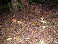
| + | File:2010-10-17 49 8 pilze1.jpg|hashrooms | ||
| + | File:2010-10-17 49 8 pilze2.jpg| | ||
| + | </gallery> | ||
| − | + | === Tracklog === | |
| − | + | [http://www.everytrail.com/view_trip.php?trip_id=1052354&code=a0fe10ab92d8e0a8d8f4f37704c05ae6 M-241 tracklog] | |
| − | [ | ||
| − | |||
| − | |||
[[Category:Expeditions]] | [[Category:Expeditions]] | ||
| − | + | [[Category:Coordinates reached]] | |
[[Category:Expeditions with photos]] | [[Category:Expeditions with photos]] | ||
| − | [[Category: | + | [[Category:Danatar]] |
| − | + | {{location|DE|HE|HP}} | |
| − | |||
| − | |||
| − | |||
| − | |||
| − | |||
| − | |||
| − | |||
| − | |||
| − | |||
| − | |||
| − | |||
| − | |||
| − | |||
| − | |||
Latest revision as of 04:15, 9 August 2019
| Sun 17 Oct 2010 in 49,8: 49.6340020, 8.8707579 geohashing.info google osm bing/os kml crox |
Location
On or next to a road in a corner of the forest at the edge of Grasellenbach, in the Bergstraße district.
Participants
Robyn- Danatar
Koepfel
Plans
Some random IP address (Robyn) said:
The hardest part about geohashing in a foreign country is that you can't tell whether this is some place it's possible to go or not. Can you go in a Naturepark in Germany without a permit? There appear to be roads, but Google Maps says it cannot calculate directions. To the best of my knowledge the most dangerous wild animals in Germany are like badgers, or maybe really pissed off elk. It's all an adventure. A really poorly prepared-for adventure. The hardest part about geohashing in a foreign country is that you can't tell whether this is some place it's possible to go or not. Can you go in a Naturepark in Germany without a permit? There appear to be roads, but Google Maps says it cannot calculate directions. To the best of my knowledge the most dangerous wild animals in Germany are like badgers, or maybe really pissed off elk. It's all an adventure. A really poorly prepared for adventure.
- Yes, you can go in a Naturpark. It's just an area where nature is preserved more than otherplace, e.g. you can't build everywhere you want. There are no elk here.
- There is an easy public transport connection from Walldorf to Grasellenbach: S-Train from Walldorf-Wiesloch station to Heidelberg main station, regular train to Weinheim and then almost one hour by bus to Grasellenbach. It's cheap, too, because it belongs to the VRN, the local public transport network: 8.30 Euros for a single trip, 14 Euros for a one-person 24-hour-ticket, 20 Euros for a 5-person 24-hour-ticket. Take a look at www.vrn.de . It's only in German, except for the timetables, which can be accessed via the little Union Jack on the left side. An overview over the service's area is behind the link "Fahrscheine/Tarif" on the main page. High definition maps are under "Linienpläne" -> "Netz-Linienpläne" -> "VRN Gesamt-Liniennetzplan", then chose a part of the map.
- I'll go there, too, on the way to my parents. I guess you can't yet tell when you will be there, can you? - Danatar 18:47, 15 October 2010 (UTC)
- I'm currently in Heidelberg, until Sunday evening, would join you if we'd share a VRN group ticket. Koepfel talk 00:53, 16 October 2010 (UTC)
Expedition
Danatar
I had planned to go to my parents' place somewhere this weekend. Robyn announced her interest to visit Sunday's coordinates, so I chose Sunday for the trip. After driving on the Autobahn for a while, I left it and continued along federal highways and country roads, going from town to town in the direction of the hashpoint. I must have followed a wrong sign somewhere, because I realized after a while that I was going too far north. That was when I switched the car's navigation system on and follow its instructions instead of my hand-written notes, which only described the specific route I had left. Two times within minutes I saw buzzards fly very close to my car for a while. I wasn't able to take a picture of them while driving, but I could take a good look.
I arrived in Grasellenbach, parked the car and walked towards the hashpoint. It was easy to find, because the road went all the way to the hashpoint and the hashpoint was in a corner of the forest easily recognizable from the satellite image. Getting the GPS unit to show the correct coordinates was more difficult and I had to do a long GPS dance because reception was low. The hashpoint jumped from the north side of the road to the south side, to the middle of the road and along the road. I finally just wrote a chalk marker on the street where other people would see it. My camera's battery died before I could take enough pictures, so I went back to the car. I went on the internet to check for changes on this page by other geohashers, found none and wrote the following comment:
Coordinates reached, no sign of other geohashers so far. More later - Danatar 16:00, 17 October 2010 (UTC)
I went to the hashpoint again and took more pictures. Still no sign of anybody else. It began to get darker, so I went back to the car and drove to my parents.
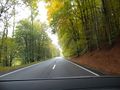
driving through the Odenwald
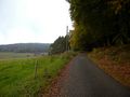
almost there
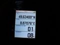
GPS
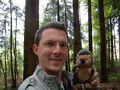
Coordinates reached

panorama
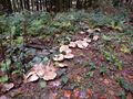
hashrooms