Difference between revisions of "2010-10-24 52 13"
imported>Lyx (→Achievements) |
imported>FippeBot m (Location) |
||
| (2 intermediate revisions by one other user not shown) | |||
| Line 79: | Line 79: | ||
File:2010-10-24-52-13-07.JPG|Geohashers close-up | File:2010-10-24-52-13-07.JPG|Geohashers close-up | ||
File:2010-10-24-52-13-08.JPG|Pumpkins & squashes at the roadside | File:2010-10-24-52-13-08.JPG|Pumpkins & squashes at the roadside | ||
| + | File:2010-10-24-52-13-09.JPG|Pumpkin lantern | ||
</gallery> | </gallery> | ||
| Line 84: | Line 85: | ||
{{#vardefine:ribbonwidth|800px}} | {{#vardefine:ribbonwidth|800px}} | ||
{{Land_geohash|latitude=52|longitude=13|date=2010-10-24|name=plypkie and lyx | {{Land_geohash|latitude=52|longitude=13|date=2010-10-24|name=plypkie and lyx | ||
| + | }} | ||
| + | {{Meet-up|latitude=52|longitude=13|date=2010-10-24|name=plypkie and lyx|other=each other | ||
}} | }} | ||
{{Public transport geohash|latitude=52|longitude=13|date=2010-10-24|name=they also | {{Public transport geohash|latitude=52|longitude=13|date=2010-10-24|name=they also | ||
| Line 91: | Line 94: | ||
[[Category:Expeditions with photos]] | [[Category:Expeditions with photos]] | ||
[[Category:Coordinates reached]] | [[Category:Coordinates reached]] | ||
| + | {{location|DE|BB|OHV}} | ||
Latest revision as of 04:20, 9 August 2019
| Sun 24 Oct 2010 in 52,13: 52.8226304, 13.0183318 geohashing.info google osm bing/os kml crox |
Location
Participants
Plans
lyx
I suggest the following, but if you want to go earlier or later, just say so!
| S+U Gesundbrunnen Bhf (Berlin) | dep | 11:22h (platform 4) | S25 direction: S Hennigsdorf Bhf |
| S Hennigsdorf Bhf | arr | 11:47h (platform 5) | |
| S Hennigsdorf Bhf | dep | 11:51h (platform 5) | RE6 direction: Pritzwalk, Bahnhof |
| Beetz-Sommerfeld, Bahnhof | arr | 12:11h |
walk ~2,3km to hash.
Sounds good to me.  See you at Gesundbrunnen shortly after 11.
Look for braided red hair and a short beard. :) Plypkie 09:03, 23 October 2010 (UTC)
Expedition
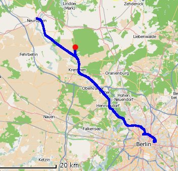
An easy ride on the S-bahn to Gesundbrunnen, where plypkie met lyx for the first time. We then grabbed S-25 out to the very end of the line, and changed onto a regional train to get closer to the hash. We were enjoying the train ride, and partially watching our progress on the GPS map, when suddenly we noticed that we had gone right past the hash point. It turns out you have to hit a button on that train, otherwise it doesn't stop at the fly-speck town that we wanted to get off at. So, we got off a few towns further on and switched to a train going back.
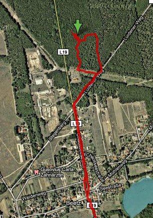
We had a nice walk through the little town, and then on a path through the forest. Once we were within 100m, we had to stomp through the bushes a bit, but it was fairly easy. It was quite windy at that point, and the trees around us were making all sorts of funny creaking noises, and their tops were flailing around quite a bit in the wind. We got out of there pretty quickly, before we could get clobbered by falling branches.
On the way back it drizzled slightly, and we stopped along the way to buy a squash and a pumpkin (mmmmm). Then...the waiting. We waited for about 20 minutes for the next train to pass, and then got on...but then a voice announced that the train would be ending in the next tiny town. So we rode the train for only a few minutes, and then stood around in the cold for over half an hour to wait for the next one.
Other than that, quite a pleasant day, and plypkie was quite overjoyed to see several hundred cranes in the fields alongside the train tracks.
Tracklog
Photos
Achievements
plypkie and lyx earned the Land geohash achievement
|
plypkie and lyx earned the Meet-up achievement
|
they also earned the Public transport geohash achievement
|


