Difference between revisions of "2011-02-19 45 -122"
imported>Jiml (Add Photos) |
imported>FippeBot m (Location) |
||
| (One intermediate revision by one other user not shown) | |||
| Line 75: | Line 75: | ||
* Land Geohash | * Land Geohash | ||
| − | |||
| − | |||
| − | |||
| − | |||
| − | |||
[[Category:Expeditions]] | [[Category:Expeditions]] | ||
| − | |||
[[Category:Expeditions with photos]] | [[Category:Expeditions with photos]] | ||
[[Category:Coordinates reached]] | [[Category:Coordinates reached]] | ||
| + | {{location|US|OR|WI}} | ||
Latest revision as of 05:36, 9 August 2019
| Sat 19 Feb 2011 in 45,-122: 45.4659988, -122.7658674 geohashing.info google osm bing/os kml crox |
Location
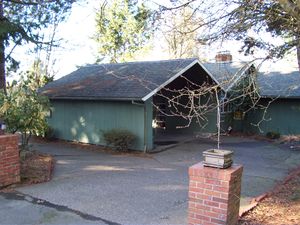
In Garden Home, Oregon, on SW Garden Home Road, in the front yard.
Participants
Plans
Jim will try to wander by on the way to errands.
Expedition
I had some errands to do, but since they were in the direction of the hashpoint, I figured I'd go there first, hoping to arrive for the earlier Winter meetup time for our Graticule(s).
The Google directions seemed fairly straight forward even though I kept moving the starting point around. The route was fairly easy, but once I got to the hashpoint, I was on a narrow two lane road with lots of traffic. I finally parked on a side street before the hashpoint, and got out to walk. But there was no shoulder on my side of the road, and I didn't like teetering on the side of the ditch, and I figured the cars wouldn't like it either. So I waited (a very long time, it seemed) for the traffic to abate so I could switch over to the bike lane/sidewalk on the other side of the road. Then, I slowly made my way to the hashpoint from that point.
I had looked at Google Maps and noticed that the hashpoint appeared to be in a yard, but didn't note if it was front or back. It proved to be in the front yard, which was lucky for reaching it. I arrived and stood on the side of the road, deciding which way to head. Most of the front yard was gravel, which made it fairly easy to wander through the hashpoint, if it was there, without trampling grass.
I started for the front door, and rang the door bell. There was a truck there, but I didn't get an answer. When I got to the door, my GPS indicated it was 39 feet to the hashpoint, and it appeared to be indicating into the house. (Apparently, the overhead trees were throwing it off.) However, with no answer, there wasn't much else to do. Off to the side there was a chain-link fence (with no gate) to the back yard, but I walked over to see if anyone was in the back yard who I could talk to.
No one was there, but as I was leaving, via a different path, I glanced at my GPS and realized I was walking through the hashpoint. I retreated to the road, and took some pictures. As usually happens in our Graticule, there were no other hashers. (Unless you bring one...)
I then headed off to visit a new work location, and do some grocery shopping before heading home.
Photos
Achievements
- Land Geohash


