Difference between revisions of "2011-04-03 53 -1"
imported>Monty (Creation of page) |
imported>FippeBot m (Location) |
||
| (2 intermediate revisions by one other user not shown) | |||
| Line 1: | Line 1: | ||
| − | + | [[Image:{{{image|20110403_53_-1_HatAndTimeAndMe.png}}}|thumb|left]] | |
| − | |||
| − | |||
| − | [[Image:{{{image| | ||
| − | |||
| − | |||
| − | |||
| − | |||
| − | |||
| − | |||
{{meetup graticule | {{meetup graticule | ||
| lat=53 | | lat=53 | ||
| Line 15: | Line 6: | ||
}} | }} | ||
| − | |||
__NOTOC__ | __NOTOC__ | ||
== Location == | == Location == | ||
| − | + | Doe Quarry Lane, Dinnington, near Rotherham. By a car park entrance, probably of the local Comprehensive School. | |
== Participants == | == Participants == | ||
| − | + | [[User:Monty|Monty]] plans to get here. | |
== Plans == | == Plans == | ||
| − | + | The day is Mother's Day, so has to fit in with the necessary plans for that. But Monty will try to be there at 11am, give or take whatever conditions on the day allow. The location is certainly publicly accessible, and virtually on the road itself, so just a matter of turning up with no obvious challenges to be anticipated in getting there. Weather on the day not checked yet, but not anticipating any incapacitating snowfalls or anything... :) | |
== Expedition == | == Expedition == | ||
| − | + | Situated near to the entrance of Dinnington Comprehensive School, I suppose I had been relieved that this was a Sunday hash, and not a weekday, because a guy with a camera could have elicited bad reactions in those circumstances. On the other hand, on arriving at the location, a bit later than I had planned, but not overly so, I found that the entrance off the road marked by our totally unbiased hashing function led into the Synthetic Turf Pitch & Pavilion, i.e. school fields, and there were either practice sessions or full-blown football matches going on, so one felt that a combination of discretion and paying conspicuous attention to the road surface was probably the best approach. It's hard to tell what any observer actually thought was going on, however. | |
| + | |||
| + | On the other hand, it soon seemed that the presence of tripod-mounted camera might well be performing its traditional, and yet unofficial, traffic-calming duty. The road was already pretty quiet (at this particular time of day, on this particular day of the week), but not so quiet as to allow many obviously speeding motorists, but the interest paid by car drivers was obvious. | ||
| + | |||
| + | |||
| + | However, when it came to locating the actual point, with the overhead view in hand the spot was pretty much obvious. On arrival, momentarily it looked like someone else had placed a marker item. An object within a metre or so of the spot the overheads suggested was the geohash point turned out, however, to be no more than a probably discarded (if not dropped and forgotten) woolly hat of some kind. Still, making a useful point of reference it was left in place, even while placing ones own temporal location device (the by now traditional big-digit alarm-clock) at the actual geohash assertion. | ||
| + | |||
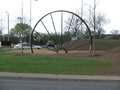
| + | And that, as they say, was that. Because while there could now be a detailed history of Dinnington (an old colliery town... as attested to by the stylised, and in no way practical, 'winding wheel' décor placed upon a nearby traffic island), and the weather report would involve some mention of rain, it was generally an uneventful expedition that was a total success and yet without any particular notable occurrences. At the time of writing there was only one known arrival (leastwise, deliberately arrived at that spot specifically for the purposes of Geohashing) and the rest of Mothering Sunday passed much as expected. | ||
== Tracklog == | == Tracklog == | ||
| − | + | None from Monty. | |
== Photos == | == Photos == | ||
| − | |||
| − | |||
| − | |||
<gallery perrow="5"> | <gallery perrow="5"> | ||
| + | Image:20110403 53 -1 DoeQuarryLane.png | Doe Quarry Lane | ||
| + | Image:20110403 53 -1 SportsField.png | Adjacent sports fields | ||
| + | Image:20110403 53 -1 AHatAndAMap.png | Gateway/Hat | ||
| + | Image:20110403 53 -1 HatAndTime.png | Best guess | ||
| + | Image:20110403 53 -1 HatAndTimeAndMe.png | Almost a grin | ||
| + | Image:20110403 53 -1 EccentricWindingWheel.png | A modern relic | ||
</gallery> | </gallery> | ||
== Achievements == | == Achievements == | ||
{{#vardefine:ribbonwidth|800px}} | {{#vardefine:ribbonwidth|800px}} | ||
| − | + | {{land geohash | latitude = 53 | longitude = -0 | date = 2011-04-02 | name = [[User:Monty|Monty]] }} | |
| − | + | {{No_batteries_geohash | latitude = 53 | longitude = -0 | date = 2011-04-02 | [[User:Monty|Monty]] | image = 20110403_53_-1_AHatAndAMap.png }} | |
| − | |||
| − | |||
| − | |||
| − | [[ | ||
| − | |||
| − | |||
| − | |||
| − | |||
| − | |||
| − | |||
[[Category:Expeditions]] | [[Category:Expeditions]] | ||
| − | |||
[[Category:Expeditions with photos]] | [[Category:Expeditions with photos]] | ||
| − | |||
[[Category:Expedition without GPS]] | [[Category:Expedition without GPS]] | ||
| − | |||
| − | |||
| − | |||
[[Category:Coordinates reached]] | [[Category:Coordinates reached]] | ||
| − | + | {{location|GB|ENG|ROT}} | |
| − | |||
| − | |||
| − | |||
| − | |||
| − | |||
| − | |||
| − | |||
| − | |||
| − | |||
Latest revision as of 06:05, 9 August 2019

| Sun 3 Apr 2011 in 53,-1: 53.3724286, -1.2031979 geohashing.info google osm bing/os kml crox |
Location
Doe Quarry Lane, Dinnington, near Rotherham. By a car park entrance, probably of the local Comprehensive School.
Participants
Monty plans to get here.
Plans
The day is Mother's Day, so has to fit in with the necessary plans for that. But Monty will try to be there at 11am, give or take whatever conditions on the day allow. The location is certainly publicly accessible, and virtually on the road itself, so just a matter of turning up with no obvious challenges to be anticipated in getting there. Weather on the day not checked yet, but not anticipating any incapacitating snowfalls or anything... :)
Expedition
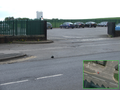
Situated near to the entrance of Dinnington Comprehensive School, I suppose I had been relieved that this was a Sunday hash, and not a weekday, because a guy with a camera could have elicited bad reactions in those circumstances. On the other hand, on arriving at the location, a bit later than I had planned, but not overly so, I found that the entrance off the road marked by our totally unbiased hashing function led into the Synthetic Turf Pitch & Pavilion, i.e. school fields, and there were either practice sessions or full-blown football matches going on, so one felt that a combination of discretion and paying conspicuous attention to the road surface was probably the best approach. It's hard to tell what any observer actually thought was going on, however.
On the other hand, it soon seemed that the presence of tripod-mounted camera might well be performing its traditional, and yet unofficial, traffic-calming duty. The road was already pretty quiet (at this particular time of day, on this particular day of the week), but not so quiet as to allow many obviously speeding motorists, but the interest paid by car drivers was obvious.
However, when it came to locating the actual point, with the overhead view in hand the spot was pretty much obvious. On arrival, momentarily it looked like someone else had placed a marker item. An object within a metre or so of the spot the overheads suggested was the geohash point turned out, however, to be no more than a probably discarded (if not dropped and forgotten) woolly hat of some kind. Still, making a useful point of reference it was left in place, even while placing ones own temporal location device (the by now traditional big-digit alarm-clock) at the actual geohash assertion.
And that, as they say, was that. Because while there could now be a detailed history of Dinnington (an old colliery town... as attested to by the stylised, and in no way practical, 'winding wheel' décor placed upon a nearby traffic island), and the weather report would involve some mention of rain, it was generally an uneventful expedition that was a total success and yet without any particular notable occurrences. At the time of writing there was only one known arrival (leastwise, deliberately arrived at that spot specifically for the purposes of Geohashing) and the rest of Mothering Sunday passed much as expected.
Tracklog
None from Monty.
Photos
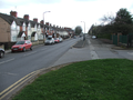
Doe Quarry Lane

Adjacent sports fields
Gateway/Hat
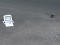
Best guess
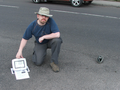
Almost a grin
A modern relic


Achievements
Monty earned the Land geohash achievement
|
This user earned the No Batteries Geohash Achievement
|