Difference between revisions of "2011-05-20 52 6"
imported>Arvid |
m (Linking to The Dance™) |
||
| (4 intermediate revisions by 3 users not shown) | |||
| Line 1: | Line 1: | ||
{{meetup graticule | {{meetup graticule | ||
| − | |||
| lat=52 | | lat=52 | ||
| lon=6 | | lon=6 | ||
| Line 13: | Line 12: | ||
==Achievements== | ==Achievements== | ||
| − | Arvid [[Walk_geohash|walked]] there. | + | *Arvid [[Walk_geohash|walked]] there, all 1.1km total! |
| − | And it is a [[Couch_Potato_Geohash|couch potato]] honorable mention. | + | *And it is a [[Couch_Potato_Geohash|couch potato]] honorable mention. |
==Expedition== | ==Expedition== | ||
| − | I | + | At 20:33 I left home, after sleeping through the afternoon. The true geohashing spirit was in the last 370m walk to the hash: I'd never been there. The first 200m were known territory. |
| + | I reached the hash at 20:39, doing [[The Dance™|the dance]]. The hash was at the edge of the road, probably just in the hedge. I could reach far enough over the hedge to get the coordinates right though, so no problem there. | ||
| + | At 20:40 I left the hashpoint and at 20:46 I was home again. | ||
| − | [[Category: | + | [http://maps.google.com/?ie=UTF8&ll=52.209829,6.905208&spn=0.008639,0.018346&z=16&layer=c&cbll=52.209909,6.905216&panoid=aC_P1WHVNvtVdPDEXpO80A&cbp=12,208.48,,0,12.32 Hashpoint in Google Streetview] |
| + | |||
| + | <Gallery> | ||
| + | File:2011-05-20 52 6-IMG 5987r.JPG| Success | ||
| + | File:2011-05-20 52 6-IMG 5988r.JPG| Amazing interesting point! | ||
| + | File:2011-05-20 52 6-IMG 5989r.JPG| Hasher, barely awake | ||
| + | </Gallery> | ||
| + | |||
| + | [[Category:Expeditions]] | ||
| + | [[Category:Expeditions with photos]] | ||
| + | [[Category:Coordinates reached]] | ||
| + | {{location|NL|OV}} | ||
Latest revision as of 16:59, 14 November 2020
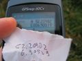
| Fri 20 May 2011 in 52,6: 52.2098210, 6.9051947 geohashing.info google osm bing/os kml crox |
Plan
Arvid cannot skip this as it is a honorable couch potato. Google claims a 550m walk there, straight line is about 470m. Arvid is the day off and will try to convince some other people to join. The hash looks to be in the middle of a T-junction, so probably accessible.
Achievements
- Arvid walked there, all 1.1km total!
- And it is a couch potato honorable mention.
Expedition
At 20:33 I left home, after sleeping through the afternoon. The true geohashing spirit was in the last 370m walk to the hash: I'd never been there. The first 200m were known territory. I reached the hash at 20:39, doing the dance. The hash was at the edge of the road, probably just in the hedge. I could reach far enough over the hedge to get the coordinates right though, so no problem there. At 20:40 I left the hashpoint and at 20:46 I was home again.
Hashpoint in Google Streetview
Success
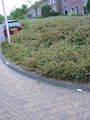
Amazing interesting point!

Hasher, barely awake


