Difference between revisions of "2011-05-14 43 -79"
From Geohashing
imported>Jiml m (Adjust result codes) |
m |
||
| (3 intermediate revisions by 3 users not shown) | |||
| Line 14: | Line 14: | ||
== Participants == | == Participants == | ||
| − | * Heiders | + | * [[User:Heiders|Heiders]] |
| Line 28: | Line 28: | ||
<gallery perrow="5"> | <gallery perrow="5"> | ||
| − | Image:Burlington_Canada_2011-05-14.jpg | | + | Image:Burlington_Canada_2011-05-14.jpg | Heiders? at the nearest intersection to the hashpoint. |
</gallery> | </gallery> | ||
| Line 43: | Line 43: | ||
[[Category:Expeditions with photos]] | [[Category:Expeditions with photos]] | ||
[[Category:Coordinates reached]] | [[Category:Coordinates reached]] | ||
| + | {{location|CA|ON|HT}} | ||
Latest revision as of 18:47, 18 March 2022
| Sat 14 May 2011 in Toronto: 43.3463619, -79.8243191 geohashing.info google osm bing/os kml crox |
Location
Burlington, Ontario, Canada
Participants
Plans
Unknown
Expedition
Based on the photo, it would appear someone made it.
Photos
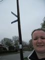
Heiders? at the nearest intersection to the hashpoint.

Achievements
- Land geohash?