Difference between revisions of "2011-07-13 -36 174"
imported>JimmyNZ |
m (per Renaming Proposal) |
||
| (7 intermediate revisions by 3 users not shown) | |||
| Line 14: | Line 14: | ||
}} | }} | ||
| − | + | ||
__NOTOC__ | __NOTOC__ | ||
== Location == | == Location == | ||
| − | Hash seems to fall in a block of bush next to Taylor Rd out in Riverhead. Kind of unusual for such an area of native bush to be in the | + | Hash seems to fall in a block of bush next to Taylor Rd out in Riverhead. |
| + | |||
| + | Kind of unusual for such an area of native bush to be in the middle of farmland so under | ||
| + | closer examination from Google it appears to be called the Colin Kerr-Taylor Memorial Reserve | ||
| + | of some type with tracks even! Sounds worth investigating. | ||
== Participants == | == Participants == | ||
| Line 26: | Line 30: | ||
== Plans == | == Plans == | ||
| − | Plans are simple | + | Plans are simple: cruise up the road armed with GPS and camera. Stroll along the tracks until I get close to the hash point then beeline through the bush until I find it. So simple, what could go wrong.. |
== Expedition == | == Expedition == | ||
| − | So found a few moments in the afternoon to shoot up there. Pity [[User:Greenslime|Greenslime]] couldn't join me. After driving past the entrance a couple of times | + | So found a few moments in the afternoon to shoot up there. Pity [[User:Greenslime|Greenslime]] couldn't join me. |
| + | |||
| + | After driving past the entrance a couple of times I eventually found a spot to pullover | ||
| + | and duck my car into. With the GPS and camera in hand I set of to find the hash spot. | ||
| + | |||
| + | All was going well until I descended down into the little valley where the hash point was. | ||
| + | After getting as close as I could using the track i pulled out the GPS only to find it was | ||
| + | reading no signal. WHAT??? | ||
| + | |||
| + | So I did the GPS dance for a couple of minutes speaking nicely to | ||
| + | it in the hopes it might regain it senses, but no joy. Eventually I circled around the track | ||
| + | network to see if I could get a better signal above it and drop down on it, but again the GPS | ||
| + | started playing up. Guess between the bush canopy and the overcast weather it wasn't going to | ||
| + | play dice with me today. Bugger (again). | ||
== Photos == | == Photos == | ||
| − | |||
| − | |||
| − | |||
<gallery perrow="5"> | <gallery perrow="5"> | ||
| + | |||
| + | Image:2011-07-13_-36_174_Google_Map.jpg | Hash is in that bush somewhere | ||
| + | Image:2011-07-13_-36_174_Colin_Kerr_Taylor_Memorial_Reserve_map.JPG | Maps with tracks are always good | ||
| + | Image:2011-07-13_-36_174_Entrance.JPG | Spotted the way in | ||
| + | Image:2011-07-13_-36_174_Entrance_sign.JPG | Entrance Sign | ||
| + | Image:2011-07-13_-36_174_Forest_and_Bird.JPG | Apparently there are trees and birds about | ||
| + | Image:2011-07-13_-36_174_Follow_the_signs.JPG | Signs are good | ||
| + | Image:2011-07-13_-36_174_Track.JPG | Track looks in good nick | ||
| + | Image:2011-07-13_-36_174_JimmyNZ_and_the_Kauri.JPG | Found a tree | ||
| + | Image:2011-07-13_-36_174_Fancy_a_rest.JPG | Seat to enjoy the birds | ||
| + | Image:2011-07-13_-36_174_GPS_you_are_weak.JPG | GPS failing me | ||
| + | Image:2011-07-13_-36_174_Bush_cover_means_no_working_GPS.JPG | I can see the sky, why can't the GPS? | ||
| + | Image:2011-07-13_-36_174_Somewhere_above_it.JPG | It's somewhere above me | ||
| + | Image:2011-07-13_-36_174_somewhere_below_it.JPG | It's now somewhere below me | ||
</gallery> | </gallery> | ||
| Line 42: | Line 70: | ||
{{#vardefine:ribbonwidth|800px}} | {{#vardefine:ribbonwidth|800px}} | ||
<!-- Add any achievement ribbons you earned below, or remove this section --> | <!-- Add any achievement ribbons you earned below, or remove this section --> | ||
| + | {{done with nature | ||
| + | |||
| + | | latitude = -36 | ||
| + | | longitude = 174 | ||
| + | | date = 2011-07-13 | ||
| + | | name = [[user:JimmyNZ|JimmyNZ]] | ||
| + | | image = 2011-07-13_-36_174_Bush_cover_means_no_working_GPS.JPG | ||
| + | }} | ||
| + | |||
| − | + | [[Category:Expeditions]] | |
| − | [[Category: | ||
[[Category:Expeditions with photos]] | [[Category:Expeditions with photos]] | ||
[[Category:Coordinates not reached]] | [[Category:Coordinates not reached]] | ||
| − | [[Category:Not reached - Technology]] | + | [[Category:Not reached - Technology]] |
| + | {{location|NZ|AUK}} | ||
Latest revision as of 14:38, 2 April 2024
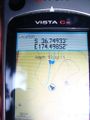
| Wed 13 Jul 2011 in -36,174: -36.7481992, 174.4984094 geohashing.info google osm bing/os kml crox |
Location
Hash seems to fall in a block of bush next to Taylor Rd out in Riverhead.
Kind of unusual for such an area of native bush to be in the middle of farmland so under closer examination from Google it appears to be called the Colin Kerr-Taylor Memorial Reserve of some type with tracks even! Sounds worth investigating.
Participants
Plans
Plans are simple: cruise up the road armed with GPS and camera. Stroll along the tracks until I get close to the hash point then beeline through the bush until I find it. So simple, what could go wrong..
Expedition
So found a few moments in the afternoon to shoot up there. Pity Greenslime couldn't join me.
After driving past the entrance a couple of times I eventually found a spot to pullover and duck my car into. With the GPS and camera in hand I set of to find the hash spot.
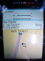
All was going well until I descended down into the little valley where the hash point was. After getting as close as I could using the track i pulled out the GPS only to find it was reading no signal. WHAT???
So I did the GPS dance for a couple of minutes speaking nicely to it in the hopes it might regain it senses, but no joy. Eventually I circled around the track network to see if I could get a better signal above it and drop down on it, but again the GPS started playing up. Guess between the bush canopy and the overcast weather it wasn't going to play dice with me today. Bugger (again).
Photos
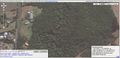
Hash is in that bush somewhere
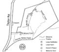
Maps with tracks are always good
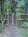
Spotted the way in
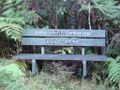
Entrance Sign
Apparently there are trees and birds about
Signs are good
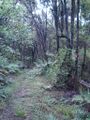
Track looks in good nick

Found a tree
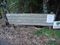
Seat to enjoy the birds
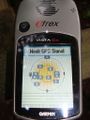
GPS failing me

I can see the sky, why can't the GPS?
It's somewhere above me
It's now somewhere below me


Achievements
JimmyNZ earned the Done with Nature consolation prize
|