Difference between revisions of "2011-07-20 52 1"
imported>Sourcerer ([live] 70 meters to the hash but tall sweet corn is blocking access.) |
m |
||
| (8 intermediate revisions by 3 users not shown) | |||
| Line 1: | Line 1: | ||
| − | |||
| − | |||
| − | |||
| − | |||
| − | |||
| − | |||
| − | |||
| − | |||
| − | |||
| − | |||
{{meetup graticule | {{meetup graticule | ||
| − | | lat=52 | + | | lat=52 |
| − | | lon=1 | + | | lon=1 |
| − | | date=2011-07-20 | + | | date=2011-07-20 |
| + | | graticule_name=Norwich | ||
| + | | graticule_link=Norwich, United Kingdom | ||
}} | }} | ||
| − | |||
| − | |||
== Location == | == Location == | ||
| − | + | ||
| + | A sweet corn field between Kirby Row and Geldeston north of the river Waveney, Norfolk, UK. | ||
== Participants == | == Participants == | ||
| − | |||
| − | + | * [[User:Sourcerer|Sourcerer]] | |
| − | |||
| − | == Expedition == | + | == Expedition - Fail == |
| − | |||
| + | *70 meters to the hash but tall sweet corn is blocking access. -- [[User:Sourcerer|Sourcerer]] [http://www.openstreetmap.org/?lat=52.475064396858215&lon=1.4940977096557617&zoom=16&layers=B000FTF @52.4751,1.4941] 19:22, 20 July 2011 (GMT+01:00) | ||
| − | + | On the way to a meeting in Norwich, I diverted via the hashpoint. After the harvest, it would have been really easy. As I was not willing to trample rapidly maturing sweet corn, the co-ordinates were not reached. I got to within 70 metres. This corn field looked healthy in contrast to others nearby which had had no rain and were doomed. | |
| − | + | ||
| − | + | The meeting in Norwich went wrong too. The speaker failed to turn up. He had been rushed to hospital with a nose bleed that would not stop so it was not the most productive of evenings. | |
== Photos == | == Photos == | ||
| − | + | ||
| − | |||
| − | |||
<gallery perrow="5"> | <gallery perrow="5"> | ||
| + | Image:2011-07-20_52_1_19-24-49-845.jpg | Corn. [http://www.openstreetmap.org/?lat=52.475064396858215&lon=1.4940977096557617&zoom=16&layers=B000FTF @52.4751,1.4941] | ||
</gallery> | </gallery> | ||
== Achievements == | == Achievements == | ||
{{#vardefine:ribbonwidth|800px}} | {{#vardefine:ribbonwidth|800px}} | ||
| − | |||
| + | {{No trespassing | ||
| + | | latitude = 52 | ||
| + | | longitude = 1 | ||
| + | | date = 2011-07-20 | ||
| + | | name = Sourcerer | ||
| + | }} | ||
| + | {{Two to the N achievement | ||
| + | | count = 6 | ||
| + | | date = 2011-07-20 | ||
| + | | latitude = 52 | ||
| + | | longitude = 1 | ||
| + | | name = Sourcerer | ||
| + | }} | ||
| − | + | {{Sourcerer_links | |
| − | + | | prev = 2011-07-18 52 1 | |
| − | + | | curr = 2011-07-20 52 1 | |
| + | | next = 2011-07-22 51 1 | ||
| + | | date = 2011-07-20 | ||
| + | }} | ||
| − | |||
| − | |||
| − | |||
| − | |||
| − | |||
| − | |||
[[Category:Expeditions]] | [[Category:Expeditions]] | ||
| − | |||
[[Category:Expeditions with photos]] | [[Category:Expeditions with photos]] | ||
| − | |||
| − | |||
| − | |||
| − | |||
| − | |||
| − | |||
| − | |||
| − | |||
| − | |||
[[Category:Coordinates not reached]] | [[Category:Coordinates not reached]] | ||
| − | + | [[Category:Not reached - No public access]] | |
| − | + | {{location|GB|ENG|NFK}} | |
| − | [[Category:Not reached - No public access]] | ||
| − | |||
| − | |||
| − | |||
Latest revision as of 10:23, 16 March 2022
| Wed 20 Jul 2011 in Norwich: 52.4747509, 1.4949577 geohashing.info google osm bing/os kml crox |
Contents
Location
A sweet corn field between Kirby Row and Geldeston north of the river Waveney, Norfolk, UK.
Participants
Expedition - Fail
- 70 meters to the hash but tall sweet corn is blocking access. -- Sourcerer @52.4751,1.4941 19:22, 20 July 2011 (GMT+01:00)
On the way to a meeting in Norwich, I diverted via the hashpoint. After the harvest, it would have been really easy. As I was not willing to trample rapidly maturing sweet corn, the co-ordinates were not reached. I got to within 70 metres. This corn field looked healthy in contrast to others nearby which had had no rain and were doomed.
The meeting in Norwich went wrong too. The speaker failed to turn up. He had been rushed to hospital with a nose bleed that would not stop so it was not the most productive of evenings.
Photos
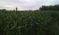
Corn. @52.4751,1.4941

Achievements
Sourcerer earned the No trespassing consolation prize
|
Sourcerer earned the Two to the N achievement
|
Expeditions and Plans
| 2011-07-20 | ||
|---|---|---|
| Mannheim, Germany | ilpadre | In the IBM office building in Mannheim. |
| Norwich, United Kingdom | Sourcerer | A sweet corn field between Kirby Row and Geldeston north of the river Waven... |
| Sheffield, United Kingdom | Monty | At the house of someone Monty knows, High Green, Sheffield. To be as p... |
Sourcerer's Expedition Links
2011-07-18 52 1 - 2011-07-20 52 1 - 2011-07-22 51 1 - KML file download of Sourcerer's expeditions for use with Google Earth.