Difference between revisions of "2011-07-21 46 -121"
imported>Michael5000 |
imported>FippeBot m (Location) |
||
| (8 intermediate revisions by 2 users not shown) | |||
| Line 1: | Line 1: | ||
| − | |||
| − | |||
| − | |||
| − | |||
| − | |||
| − | |||
| − | |||
| − | |||
| − | |||
{{meetup graticule | {{meetup graticule | ||
| lat=46 | | lat=46 | ||
| Line 14: | Line 5: | ||
}} | }} | ||
| − | |||
__NOTOC__ | __NOTOC__ | ||
| + | |||
| + | [[File:2011-07-21 46 -121 sign.JPG|400 px]] | ||
| + | |||
== Location == | == Location == | ||
| Line 33: | Line 26: | ||
So, we were away from home for seven days and went on nine geohashing expeditions -- but we didn't geohash on Day 6, so no [[Endurance Geohashing]] award for us. I hereby award us Honorable Mention, though. | So, we were away from home for seven days and went on nine geohashing expeditions -- but we didn't geohash on Day 6, so no [[Endurance Geohashing]] award for us. I hereby award us Honorable Mention, though. | ||
| − | + | Expedition Success! | |
| − | + | == Photos == | |
| − | |||
| − | |||
| − | |||
| − | |||
<gallery perrow="5"> | <gallery perrow="5"> | ||
| + | File:2011-07-21 46 -121 sign.JPG|Indeed. | ||
| + | File:2011-07-21 46 -121 view.JPG|The view downslope to the road from the hashpoint. | ||
| + | File:2011-07-21 46 -121 grin.JPG|Better than average Stupid Grins, for us. | ||
</gallery> | </gallery> | ||
== Achievements == | == Achievements == | ||
{{#vardefine:ribbonwidth|800px}} | {{#vardefine:ribbonwidth|800px}} | ||
| − | + | * (Self-Awarded) Honorable Mention for [[Endurance Geohashing]] | |
| − | + | {{Minesweeper geohash | |
| − | + | | graticule = Portland, Oregon | |
| + | | ranknumber = 4 | ||
| + | | n = | ||
| + | | ne = true | ||
| + | | e = | ||
| + | | se = | ||
| + | | s = | ||
| + | | sw = true | ||
| + | | w = true | ||
| + | | nw = true | ||
| + | | name = Michael5000 | ||
| + | }} | ||
[[Category:Expeditions]] | [[Category:Expeditions]] | ||
[[Category:Expeditions with photos]] | [[Category:Expeditions with photos]] | ||
[[Category:Coordinates reached]] | [[Category:Coordinates reached]] | ||
| + | {{location|US|WA|YA}} | ||
Latest revision as of 00:11, 13 August 2019
| Thu 21 Jul 2011 in 46,-121: 46.6352671, -121.2756540 geohashing.info google osm bing/os kml crox |

Location
In the Snoqualmie National Forest near White Pass, Highway 12, in the Washington Cascades.
Participants
Expedition
We woke up in Moscow, Idaho, intending to spend the day travelling roughly halfway home towards Portland. Unfortunately, none of the hashpoints in southeast Washington or northeast Oregon gave us any love at all. The only destination that looked at all interesting was actually in one of Portland's surrounding graticules, Mt. Rainier, a good 200 miles away. So, after thinking about it for a while, we launched an epic cross-Washington journey. We passed through the beautiful rolling agricultural land of the Palouse! We crossed the ugly agricultural uplands of the Scablands! We crossed the Columbia, and a wide desert ridge into the verdant Yakima Valley! Then, we climbed up into the forests of the Cascades, thicker and thicker, until we had cut the 200 miles to one mile.
The hashpoint was within a YMCA camp compound, and involved a bit of a scramble up a wooded slope from the access road. Fortunately, we are intrepid, and were shortly astride the hashpoint. Pictures, triumph, and back to the road. And, having come this far, and with rain starting to fall, we went ahead and headed back home, which is why I am writing this from the familiar confines of my usual coffeeshop.
So, we were away from home for seven days and went on nine geohashing expeditions -- but we didn't geohash on Day 6, so no Endurance Geohashing award for us. I hereby award us Honorable Mention, though.
Expedition Success!
Photos
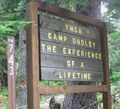
Indeed.
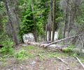
The view downslope to the road from the hashpoint.
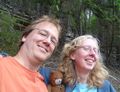
Better than average Stupid Grins, for us.


Achievements
- (Self-Awarded) Honorable Mention for Endurance Geohashing
Michael5000 achieved level 4 of the Minesweeper Geohash achievement
|