Difference between revisions of "2010-11-12 38 -74"
From Geohashing
imported>Jevanyn ([retro] With 2011-09-04 38 -74 out of reach, i went to the retrohash for november 12th 2010.) |
imported>FippeBot m (Location) |
||
| (4 intermediate revisions by 2 users not shown) | |||
| Line 1: | Line 1: | ||
| − | |||
<!-- If you did not specify these parameters in the template, please substitute appropriate values for IMAGE, LAT, LON, and DATE (YYYY-MM-DD format) | <!-- If you did not specify these parameters in the template, please substitute appropriate values for IMAGE, LAT, LON, and DATE (YYYY-MM-DD format) | ||
| Line 13: | Line 12: | ||
| lon=-74 | | lon=-74 | ||
| date=2010-11-12 | | date=2010-11-12 | ||
| + | | retro=1 | ||
}} | }} | ||
| − | + | ||
__NOTOC__ | __NOTOC__ | ||
== Location == | == Location == | ||
<!-- where you've surveyed the hash to be --> | <!-- where you've surveyed the hash to be --> | ||
| + | |||
| + | A park at the turn of ...?, West Cape May | ||
== Participants == | == Participants == | ||
<!-- who attended --> | <!-- who attended --> | ||
| + | |||
| + | * [[User:Jevanyn|Jevanyn]] | ||
== Plans == | == Plans == | ||
<!-- what were the original plans --> | <!-- what were the original plans --> | ||
| + | |||
| + | With [[2011-09-04 38 -74]] out of reach, I went to the retrohash for November 12th, 2010. | ||
| + | |||
== Expedition == | == Expedition == | ||
| Line 39: | Line 46: | ||
--> | --> | ||
<gallery perrow="5"> | <gallery perrow="5"> | ||
| + | |||
| + | Image:2010-11-12_38_-74_09-11-56-329.jpg | The view south [http://www.openstreetmap.org/?lat=38.9704&lon=-74.9396&zoom=16&layers=B000FTF @38.9704,-74.9396] | ||
| + | |||
| + | Image:2010-11-12_38_-74_09-12-17-657.jpg | The view west [http://www.openstreetmap.org/?lat=38.9704&lon=-74.9396&zoom=16&layers=B000FTF @38.9704,-74.9396] | ||
</gallery> | </gallery> | ||
| Line 46: | Line 57: | ||
| − | + | [[Category:Retro coordinates reached]] | |
| − | + | [[Category:Expeditions with photos]] | |
| − | [[Category: | ||
| − | |||
| − | |||
| − | |||
| − | |||
| − | |||
| − | |||
| − | |||
| − | |||
| − | |||
| − | |||
| − | |||
| − | |||
| − | |||
| − | |||
| − | |||
| − | <!-- | + | <!-- [[Category:Expeditions]] --> |
| − | [[Category: | + | {{location|US|NJ|CP}} |
| − | -- | ||
| − | |||
| − | |||
| − | |||
| − | |||
| − | |||
Latest revision as of 04:34, 9 August 2019
| Fri 12 Nov 2010 in 38,-74: 38.9703560, -74.9395426 geohashing.info google osm bing/os kml crox |
Location
A park at the turn of ...?, West Cape May
Participants
Plans
With 2011-09-04 38 -74 out of reach, I went to the retrohash for November 12th, 2010.
Expedition
- With 2011-09-04 38 -74 out of reach, i went to the retrohash for november 12th 2010. -- Jevanyn @38.9704,-74.9396 09:11, 04 September 2011 (EDT)
Tracklog
Photos
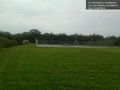
The view south @38.9704,-74.9396
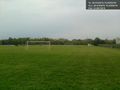
The view west @38.9704,-74.9396

