Difference between revisions of "2012-01-07 41 -88"
From Geohashing
imported>EvilUncleNomo ([live picture] Evil [http://www.openstreetmap.org/?lat=41.47036727&lon=-88.44933610&zoom=16&layers=B000FTF @41.4704,-88.4493]) |
imported>FippeBot m (Location) |
||
| (6 intermediate revisions by one other user not shown) | |||
| Line 10: | Line 10: | ||
== Participants == | == Participants == | ||
| − | * [[User:EvilUncleNomo|EvilUncleNomo]] and | + | * [[User:EvilUncleNomo|EvilUncleNomo]] and [[User:The Wife|The Wife]] |
== Plans == | == Plans == | ||
| − | * [[User:EvilUncleNomo|EvilUncleNomo]] and | + | * [[User:EvilUncleNomo|EvilUncleNomo]] and [[User:The Wife|The Wife]] are planning on attempting this geohash Saturday afternoon. |
== Expedition == | == Expedition == | ||
| − | + | Saturday afternoon we put on our geohashing boots and set out to find the target. On the way there we saw lots of empty corn fields and more than a few grain elevators. North of the target, across the road, was a quarry surrounded by "No Trespassing" signs and hidden from the road by a small man-made hill. I defied the law by climbing to the top of the hill and taking a picture. Afterwards, as no authorities appeared to prosecute my wickedness, we continued on to the geohash. | |
| − | |||
| − | |||
| − | |||
== Photos == | == Photos == | ||
| − | |||
| − | |||
| − | |||
<gallery perrow="5"> | <gallery perrow="5"> | ||
| − | Image:2012-01-07_41_-88_16- | + | Image:2012-01-07_41_-88_16-10-49-954.jpg | Danger, Will Robinson! Danger! |
| − | Image:2012-01-07_41_-88_16- | + | Image:2012-01-07_41_-88_16-11-18-574.jpg | Quarry across the street from the target. |
| − | Image:2012-01-07_41_-88_16- | + | Image:2012-01-07_41_-88_16-21-46-281.jpg | Evil |
| − | Image:2012-01-07_41_-88_16- | + | Image:2012-01-07_41_-88_16-22-07-777.jpg | The wife |
</gallery> | </gallery> | ||
| − | |||
| − | |||
| − | |||
| − | |||
| − | |||
| − | |||
| − | |||
| − | |||
| − | |||
| − | |||
| − | |||
| − | |||
| − | |||
| − | |||
[[Category:Expeditions]] | [[Category:Expeditions]] | ||
| − | |||
[[Category:Expeditions with photos]] | [[Category:Expeditions with photos]] | ||
| − | |||
| − | |||
| − | |||
| − | |||
| − | |||
[[Category:Coordinates reached]] | [[Category:Coordinates reached]] | ||
| − | + | {{location|US|IL|KA}} | |
| − | |||
| − | |||
| − | |||
| − | |||
| − | |||
| − | |||
| − | |||
| − | |||
| − | |||
Latest revision as of 01:58, 13 August 2019
| Sat 7 Jan 2012 in 41,-88: 41.4703656, -88.4493502 geohashing.info google osm bing/os kml crox |
Location
In a field in Newark, Illinois, U.S.A. It looks like some kind of a quarry is across the street.
Participants
Plans
- EvilUncleNomo and The Wife are planning on attempting this geohash Saturday afternoon.
Expedition
Saturday afternoon we put on our geohashing boots and set out to find the target. On the way there we saw lots of empty corn fields and more than a few grain elevators. North of the target, across the road, was a quarry surrounded by "No Trespassing" signs and hidden from the road by a small man-made hill. I defied the law by climbing to the top of the hill and taking a picture. Afterwards, as no authorities appeared to prosecute my wickedness, we continued on to the geohash.
Photos
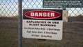
Danger, Will Robinson! Danger!
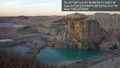
Quarry across the street from the target.
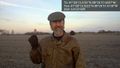
Evil
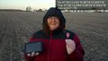
The wife


