Difference between revisions of "2012-03-03 47 -52"
imported>Quiglax |
m (More specific location) |
||
| (3 intermediate revisions by 3 users not shown) | |||
| Line 1: | Line 1: | ||
| − | |||
| − | |||
| − | |||
| − | |||
| − | |||
| − | |||
| − | |||
| − | |||
| − | |||
{{meetup graticule | {{meetup graticule | ||
| lat=47 | | lat=47 | ||
| Line 14: | Line 5: | ||
}} | }} | ||
| − | |||
__NOTOC__ | __NOTOC__ | ||
== Location == | == Location == | ||
| − | |||
Bay Bulls Area | Bay Bulls Area | ||
== Participants == | == Participants == | ||
| − | |||
[[User:Quiglax|Thomas]] - The Mastermind | [[User:Quiglax|Thomas]] - The Mastermind | ||
| Line 31: | Line 19: | ||
== Plans == | == Plans == | ||
| − | |||
Since this is the first geohash on land since I started checking, I plan to drive down with my daughter and test out the GPS function on my phone. | Since this is the first geohash on land since I started checking, I plan to drive down with my daughter and test out the GPS function on my phone. | ||
== Expedition == | == Expedition == | ||
| − | |||
I was feeding Kristina before hitting the road, and my sister called and decided to drop up for a surprise visit. I convinced her to come with me and we decided to take the dog with us. | I was feeding Kristina before hitting the road, and my sister called and decided to drop up for a surprise visit. I convinced her to come with me and we decided to take the dog with us. | ||
| Line 45: | Line 31: | ||
== Photos == | == Photos == | ||
| − | |||
| − | |||
| − | |||
<gallery perrow="5"> | <gallery perrow="5"> | ||
Image:2012-03-03 47 -57 proof.JPG | Proof we made it, or I made my phone lie. | Image:2012-03-03 47 -57 proof.JPG | Proof we made it, or I made my phone lie. | ||
| Line 57: | Line 40: | ||
== Achievements == | == Achievements == | ||
{{#vardefine:ribbonwidth|800px}} | {{#vardefine:ribbonwidth|800px}} | ||
| − | + | {{land geohash | |
| − | + | | latitude = 47 | |
| − | + | | longitude = -52 | |
| − | + | | date = 2012-03-03 | |
| + | | name = Thomas | ||
| + | }} | ||
| − | + | {{Frozen Geohash | |
| − | + | | latitude = 47 | |
| − | + | | longitude = -52 | |
| − | + | | date = 2012-03-03 | |
| − | + | | temperature = -1°C | |
| − | + | | name = Thomas | |
| − | + | }} | |
| − | |||
| Line 75: | Line 59: | ||
[[Category:Expeditions with photos]] | [[Category:Expeditions with photos]] | ||
[[Category:Coordinates reached]] | [[Category:Coordinates reached]] | ||
| − | + | {{location|CA|NL|N}} | |
| − | |||
| − | |||
| − | |||
| − | |||
| − | |||
| − | |||
| − | |||
| − | |||
| − | |||
| − | |||
| − | |||
| − | |||
| − | |||
| − | |||
| − | |||
| − | |||
| − | |||
| − | |||
| − | |||
| − | |||
Latest revision as of 23:51, 9 August 2020
| Sat 3 Mar 2012 in 47,-52: 47.3299215, -52.8193385 geohashing.info google osm bing/os kml crox |
Location
Bay Bulls Area
Participants
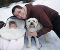
Thomas - The Mastermind
Kristina - My two and a half month old daughter
Delana - My sister
Teddy - My dog
Plans
Since this is the first geohash on land since I started checking, I plan to drive down with my daughter and test out the GPS function on my phone.
Expedition
I was feeding Kristina before hitting the road, and my sister called and decided to drop up for a surprise visit. I convinced her to come with me and we decided to take the dog with us.
We headed out. My phone didn't properly save the coordinates, so after a bit of searching on the back road and using my backup printed map, we found the spot to park.
We were lucky as this geohash was only about 44 meters from the road. I reprogrammed my phone, and we started off into the woods. A few minutes in and we came to a clearing with a log structure, and lots of animals bit lying around. Looks like is was used for skinning and chopping up rabbits.
Checked the GPS and realized we walked too far in, and to the left. Another minute of so and we were at another structure. No idea what this one was for...really should have taken pictures. Another GPS check, another few meters and we were there. :)
Photos
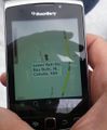
Proof we made it, or I made my phone lie.
Me, Kristina and Teddy

Delana, Kristina and Teddy

The Whole Gang


Achievements
Thomas earned the Land geohash achievement
|
Thomas earned the Frozen Geohash Achievement
|