Difference between revisions of "2012-04-29 50 -122"
imported>Wijnland (succes) |
m (per Renaming Proposal) |
||
| (4 intermediate revisions by 3 users not shown) | |||
| Line 4: | Line 4: | ||
| date=2012-04-29 | | date=2012-04-29 | ||
}} | }} | ||
| + | __NOTOC__ | ||
| + | |||
| + | [[Image:20120429-50-122-12.jpg | 600px]] | ||
| + | Part two of Wijnlands gehash camping weekend in 50 -122 ([[2012-04-28_50_-122|Part 1]]) | ||
==Location== | ==Location== | ||
| − | close to | + | close to Duffey lake, between Pemberton and Lilloet |
==Participants== | ==Participants== | ||
| Line 15: | Line 19: | ||
==Expeditions== | ==Expeditions== | ||
| − | + | The morning started of a little gray, and after waking up I made coffee for me and a girl with bike that camped out on the same parking. She was not a geohasher, but surely traveled in the same spirit as she threw a dart on a map and was now biking there all the way! hurrah for that. From the parking to the trail head it was about 25km and I decided to join her for that bit of the route on my bike which I brought with me in the back of my van. As soon a we were packed and started riding the sky opened up and it was a truly beautiful day! The road was very nice and had a lot of great views. At the end of Duffey lake we stopped for another coffee brewed on a camp-stove. After that we parted ways, she biked on and I parked my bike at the trail head and went further by snowshoe. | |
| + | |||
| + | <gallery> | ||
| + | Image:20120429-50-122-7680.jpg | On the Bike | ||
| + | Image:20120429-50-122-7699.jpg | View over Duffey Lake | ||
| + | Image:20120429-50-122-7704.jpg | Coffee brake | ||
| + | Image:20120429-50-122-12.jpg | Awesome view | ||
| + | Image:tracklog_20120428N50W122.png | Tracklog | ||
| + | </gallery> | ||
| + | |||
| + | The trail was very reasonable and the view was great so I was a happy hasher, there were many old avalanches that had crossed the road and these were not cleared but on snowshoes they were easy to pass. At some point I had to get off the trail and make my way trough the forest, downhill, cross a creek, and uphill again to the coordinates. Off the trail the snow was very soft and about one meter deep, the snowshoes helped a bit but not much and in many spots there were dense alder shrubs growing which were hard to get get over because they were covered in snow that was thinner and even softer. The creek was not to deep luckily and I came prepared with rubber boots so made it to the other side dry. uphill was even harder and there were many obstacles like dense shrubs and big rocks I had to go around. The tracklog map shows my very slow and winding progress. A more then one occasion I considered returning, but I made it to the coordinates right at 1500 the limit I set myself to ensure a safe return before dark... | ||
| + | |||
| + | On the return to the path I could butslide a bit down the hill and also found a bit easier track. I could cross the creak over an avalanche formed snow bridge that seemed strong enough, and i did not fall trough luckily. I still had to hike back to the highway where I arrived at 1730. then I had to bike back for 80min over some steep slopes before I was back at my van and could return to Vancouver. I was planning to get a second geohash that day by visiting the coordinates of the Vancouver graticule along the sea to sky, but bailed on that one because i was tired and it was fully dark before I made it back that far. | ||
| − | |||
<gallery> | <gallery> | ||
| + | Image:tracklog_20120428N50W122_2.png | Tracklog off road part | ||
| + | Image:20120429-50-122-7742.jpg | View at Cutblock | ||
| + | Image:20120429-50-122-7752.jpg | Avalanche rubble over trail | ||
| + | Image:20120429-50-122-7757.jpg | The Creek | ||
| + | Image:20120429-50-122-7761.jpg | Me at the Creek | ||
| + | Image:20120429-50-122-7772.jpg | View from the hash location | ||
| + | Image:20120429-50-122-7766.jpg | This was nice snow... | ||
| + | Image:20120429-50-122-7764.jpg | Coordinates Reached! | ||
| + | Image:20120429-50-122-7769.jpg | Tired Grin | ||
| + | Image:20120429-50-122-7775.jpg | Buttsliding down | ||
| + | Image:20120429-50-122-7781.jpg | Snow bridge | ||
| + | Image:20120429-50-122-7785.jpg | There it was | ||
</gallery> | </gallery> | ||
| + | |||
| + | |||
| + | == Achievements == | ||
| + | {{#vardefine:ribbonwidth|800px}} | ||
| + | |||
| + | * I think this was quite a tour and am thinking of claiming the MNIMB achievement, but the weather was all nice and I enjoyed myself so much that I have doubts if this was tough enough? maybe somebody who has this achievement can review my report and give some judgement. (Wijnland) > As proposed by [[User:relet]] I claim a 'loves mother nature' ribbin. | ||
| + | {{ribbon | color = darkgreen | icon = OWN Ribbon.jpg | achievement = loves Mother Nature | customtitle = | action = transcending the silly contest and just enjoying the experience}} | ||
| + | . | ||
| + | {{land geohash | latitude = 50 | longitude = -122 | date = 2012-04-29 | image = 20120429-50-122-7766.jpg }} | ||
| + | {{consecutive geohash | count = 2 | latitude = 50 | name = Wijnland | longitude = -122 | date = 2012-04-28 }} | ||
[[Category:Meetup on 2012-04-29]] | [[Category:Meetup on 2012-04-29]] | ||
| Line 25: | Line 62: | ||
[[Category:Expeditions]] | [[Category:Expeditions]] | ||
[[Category:Coordinates reached]] | [[Category:Coordinates reached]] | ||
| + | {{location|CA|BC|SL}} | ||
Latest revision as of 13:50, 2 April 2024
| Sun 29 Apr 2012 in 50,-122: 50.4091492, -122.2376230 geohashing.info google osm bing/os kml crox |
 Part two of Wijnlands gehash camping weekend in 50 -122 (Part 1)
Location
close to Duffey lake, between Pemberton and Lilloet
Participants
Plans
wijnland will go there for a camping hash
Expeditions
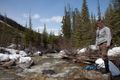
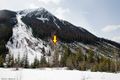
The morning started of a little gray, and after waking up I made coffee for me and a girl with bike that camped out on the same parking. She was not a geohasher, but surely traveled in the same spirit as she threw a dart on a map and was now biking there all the way! hurrah for that. From the parking to the trail head it was about 25km and I decided to join her for that bit of the route on my bike which I brought with me in the back of my van. As soon a we were packed and started riding the sky opened up and it was a truly beautiful day! The road was very nice and had a lot of great views. At the end of Duffey lake we stopped for another coffee brewed on a camp-stove. After that we parted ways, she biked on and I parked my bike at the trail head and went further by snowshoe.
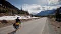
On the Bike
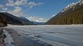
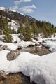
View over Duffey Lake
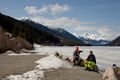
Coffee brake
Awesome view
Tracklog


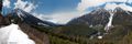
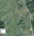
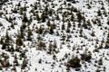
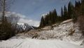
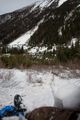
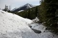
The trail was very reasonable and the view was great so I was a happy hasher, there were many old avalanches that had crossed the road and these were not cleared but on snowshoes they were easy to pass. At some point I had to get off the trail and make my way trough the forest, downhill, cross a creek, and uphill again to the coordinates. Off the trail the snow was very soft and about one meter deep, the snowshoes helped a bit but not much and in many spots there were dense alder shrubs growing which were hard to get get over because they were covered in snow that was thinner and even softer. The creek was not to deep luckily and I came prepared with rubber boots so made it to the other side dry. uphill was even harder and there were many obstacles like dense shrubs and big rocks I had to go around. The tracklog map shows my very slow and winding progress. A more then one occasion I considered returning, but I made it to the coordinates right at 1500 the limit I set myself to ensure a safe return before dark...
On the return to the path I could butslide a bit down the hill and also found a bit easier track. I could cross the creak over an avalanche formed snow bridge that seemed strong enough, and i did not fall trough luckily. I still had to hike back to the highway where I arrived at 1730. then I had to bike back for 80min over some steep slopes before I was back at my van and could return to Vancouver. I was planning to get a second geohash that day by visiting the coordinates of the Vancouver graticule along the sea to sky, but bailed on that one because i was tired and it was fully dark before I made it back that far.
Tracklog off road part
View at Cutblock
Avalanche rubble over trail
The Creek
Me at the Creek
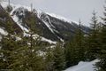
View from the hash location
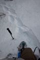
This was nice snow...
Coordinates Reached!

Tired Grin
Buttsliding down
Snow bridge
There it was


Achievements
- I think this was quite a tour and am thinking of claiming the MNIMB achievement, but the weather was all nice and I enjoyed myself so much that I have doubts if this was tough enough? maybe somebody who has this achievement can review my report and give some judgement. (Wijnland) > As proposed by User:relet I claim a 'loves mother nature' ribbin.
This user loves Mother Nature
|
.
This user earned the Land geohash achievement
|
Wijnland earned the Consecutive geohash achievement
|