Difference between revisions of "2012-05-14 46 -123"
imported>Michael5000 (Created page with "{{subst:Expedition |lat = 46 |lon = -123 |date = 2012-05-14 }}") |
Michael5000 (talk | contribs) (→Participants) |
||
| (14 intermediate revisions by 2 users not shown) | |||
| Line 1: | Line 1: | ||
| − | |||
| − | |||
| − | |||
| − | |||
| − | |||
{{meetup graticule | {{meetup graticule | ||
| lat=46 | | lat=46 | ||
| Line 10: | Line 5: | ||
}} | }} | ||
| − | |||
__NOTOC__ | __NOTOC__ | ||
== Location == | == Location == | ||
| − | + | ||
| + | On the beach west of Astoria, Oregon. | ||
== Participants == | == Participants == | ||
| − | |||
| − | |||
| − | + | *[[User:Michael5000|Michael5000]] | |
| − | |||
== Expedition == | == Expedition == | ||
| − | |||
| − | + | A hashpoint on the beach seemed pretty novel (although it turns out [[2012-05-14 29 -80|it wasn't]]!) and a great excuse for a little road trip. I started with [[2012-05-14 46 -122|a less interesting hashpoint]], grabbed some lunch, and headed down the Columbia to the coast. | |
| − | + | ||
| + | Certain skeptical friends thought the hashpoint would be underwater, but I was not born yesterday and timed my arrival to coincide with low tide. That didn't make this an especially easy expedition, though. It was on a fairly remote stretch of beach, and the only available access point was flooded two points by the swampy ponds that tend to form behind coastal sand dunes. | ||
| + | |||
| + | [[File:2012-05-14 46 -123 pond.JPG|500 px]] | ||
| + | |||
| + | I spent a while trying to find alternatives, but eventually just had to find a walking stick and be glad that I hadn't worn good shoes. | ||
| + | |||
| + | [[File:2012-05-14 46 -123 crossing.JPG|500 px]] | ||
| + | |||
| + | That having been done, it was just a matter of crossing diagonally across some dunes... | ||
| + | |||
| + | [[File:2012-05-14 46 -123 dunes.JPG|500 px]] | ||
| + | |||
| + | to get to the beach. | ||
| + | |||
| + | [[File:2012-05-14 46 -123 beach.JPG|500 px]] | ||
| + | |||
| + | Kind of a boring beach, really. Where I grew up, the beaches are strewn with rocks and driftwood and creeks and various interesting features; this was just BEACH. My camera had a hard time finding anything to focus on. | ||
| + | |||
| + | Oregon's beaches are technically public highway, a legal fiction (albeit an excellent one) that prevents private ownership of the seashore. This does mean, though, that on some stretches of beach you may actually be surprised by someone taking the "public highway" thing seriously! | ||
| + | |||
| + | [[File:2012-05-14 46 -123 car.JPG|500 px]] | ||
| + | |||
| + | But enough about our charming local customs! I proceeded to the hashpoint. It was a nice walk, about a mile each way, except for the wading. Not for the first time, I was glad I pack a towel and extra shoes in the Geohashing Expedition Vehicle. | ||
== Photos == | == Photos == | ||
| − | + | ||
| − | |||
| − | |||
<gallery perrow="5"> | <gallery perrow="5"> | ||
| + | File:2012-05-14 46 -123 elevation.JPG|"-4 feet" -- which is probably correct, relative to high tide! | ||
| + | File:2012-05-14 46 -123 me.JPG|I, Geohasher | ||
| + | File:2012-05-14 46 -123 Bear.JPG|Beachcombear | ||
</gallery> | </gallery> | ||
== Achievements == | == Achievements == | ||
{{#vardefine:ribbonwidth|800px}} | {{#vardefine:ribbonwidth|800px}} | ||
| − | |||
| − | |||
| − | |||
| − | |||
| − | |||
| − | |||
| − | |||
| − | |||
| − | |||
| − | |||
| − | |||
| − | |||
[[Category:Expeditions]] | [[Category:Expeditions]] | ||
| − | |||
[[Category:Expeditions with photos]] | [[Category:Expeditions with photos]] | ||
| − | |||
| − | |||
| − | |||
| − | |||
| − | |||
[[Category:Coordinates reached]] | [[Category:Coordinates reached]] | ||
| − | |||
| − | + | {{Multihash2 | count = 2 | date = 2012-05-14 | name = [[User:Michael5000|Michael5000]] }} | |
| − | + | {{location|US|OR|CT}} | |
| − | |||
| − | |||
| − | |||
| − | [[ | ||
| − | |||
| − | |||
Latest revision as of 08:06, 20 February 2022
| Mon 14 May 2012 in 46,-123: 46.1377452, -123.9602435 geohashing.info google osm bing/os kml crox |
Location
On the beach west of Astoria, Oregon.
Participants
Expedition
A hashpoint on the beach seemed pretty novel (although it turns out it wasn't!) and a great excuse for a little road trip. I started with a less interesting hashpoint, grabbed some lunch, and headed down the Columbia to the coast.
Certain skeptical friends thought the hashpoint would be underwater, but I was not born yesterday and timed my arrival to coincide with low tide. That didn't make this an especially easy expedition, though. It was on a fairly remote stretch of beach, and the only available access point was flooded two points by the swampy ponds that tend to form behind coastal sand dunes.

I spent a while trying to find alternatives, but eventually just had to find a walking stick and be glad that I hadn't worn good shoes.

That having been done, it was just a matter of crossing diagonally across some dunes...

to get to the beach.

Kind of a boring beach, really. Where I grew up, the beaches are strewn with rocks and driftwood and creeks and various interesting features; this was just BEACH. My camera had a hard time finding anything to focus on.
Oregon's beaches are technically public highway, a legal fiction (albeit an excellent one) that prevents private ownership of the seashore. This does mean, though, that on some stretches of beach you may actually be surprised by someone taking the "public highway" thing seriously!

But enough about our charming local customs! I proceeded to the hashpoint. It was a nice walk, about a mile each way, except for the wading. Not for the first time, I was glad I pack a towel and extra shoes in the Geohashing Expedition Vehicle.
Photos
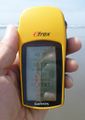
"-4 feet" -- which is probably correct, relative to high tide!

I, Geohasher

Beachcombear


Achievements
Michael5000 earned the Multihash Achievement
|