Difference between revisions of "2012-05-23 43 -79"
imported>Splitdipless |
m (More specific location) |
||
| (2 intermediate revisions by 2 users not shown) | |||
| Line 1: | Line 1: | ||
| − | |||
| − | |||
| − | |||
| − | |||
| − | |||
| − | |||
| − | |||
| − | |||
| − | |||
{{meetup graticule | {{meetup graticule | ||
| lat=43 | | lat=43 | ||
| Line 14: | Line 5: | ||
}} | }} | ||
| − | |||
__NOTOC__ | __NOTOC__ | ||
== Location == | == Location == | ||
| − | + | Like satellite imagery predicted, the point was in a rather nice park in Rickhond Hill. | |
== Participants == | == Participants == | ||
| − | |||
| − | |||
#[[User:Splitdipless|Splitdipless]] | #[[User:Splitdipless|Splitdipless]] | ||
== Plans == | == Plans == | ||
| − | |||
I have a work-out at the dojo first, but will set out to arrive about 8pm. Plenty of time before sunset. | I have a work-out at the dojo first, but will set out to arrive about 8pm. Plenty of time before sunset. | ||
== Expedition == | == Expedition == | ||
| − | + | After my work-out, I threw my gym bag in the trunk then realized I forgot my GPS and camera. Luckily, that very afternoon I mentioned to my colleague at work that people use their phones now for all sorts of functions other then calling and number storage, and became resolute in proceeding to the geohash using just my phone. I downloaded an app (thank-you GPS Status and Toolbox) and headed out. It works just as good as my Garmin. I may end up using it more often. | |
| − | + | The spot was beyond the 1st base foul line, but probably still 'in the ballpark.' I snapped some pictures and I went on my merry way. | |
| − | |||
== Photos == | == Photos == | ||
| − | |||
| − | |||
| − | |||
<gallery perrow="5"> | <gallery perrow="5"> | ||
| + | Image:2012-05-23 43 -79 0.7 A.jpg | Very technical interface. I love it. | ||
| + | Image:2012-05-23 43 -79 0.7 B.jpg | Towards 'home run territory.' | ||
| + | Image:2012-05-23 43 -79 0.7 C.jpg | No night game tonight. | ||
| + | Image:2012-05-23 43 -79 0.7 D.jpg | Grin? Check. | ||
</gallery> | </gallery> | ||
== Achievements == | == Achievements == | ||
{{#vardefine:ribbonwidth|800px}} | {{#vardefine:ribbonwidth|800px}} | ||
| − | + | Nothing new. | |
| − | |||
| − | |||
| − | |||
| − | |||
| − | |||
| − | |||
| − | |||
| − | |||
| − | |||
[[Category:Expeditions]] | [[Category:Expeditions]] | ||
| − | |||
[[Category:Expeditions with photos]] | [[Category:Expeditions with photos]] | ||
| − | |||
| − | |||
| − | |||
| − | |||
| − | |||
[[Category:Coordinates reached]] | [[Category:Coordinates reached]] | ||
| − | + | {{location|CA|ON|YO}} | |
| − | |||
| − | |||
| − | |||
| − | |||
| − | |||
| − | |||
| − | |||
| − | |||
| − | |||
Latest revision as of 23:55, 9 August 2020
| Wed 23 May 2012 in 43,-79: 43.8768542, -79.3973981 geohashing.info google osm bing/os kml crox |
Location
Like satellite imagery predicted, the point was in a rather nice park in Rickhond Hill.
Participants
Plans
I have a work-out at the dojo first, but will set out to arrive about 8pm. Plenty of time before sunset.
Expedition
After my work-out, I threw my gym bag in the trunk then realized I forgot my GPS and camera. Luckily, that very afternoon I mentioned to my colleague at work that people use their phones now for all sorts of functions other then calling and number storage, and became resolute in proceeding to the geohash using just my phone. I downloaded an app (thank-you GPS Status and Toolbox) and headed out. It works just as good as my Garmin. I may end up using it more often.
The spot was beyond the 1st base foul line, but probably still 'in the ballpark.' I snapped some pictures and I went on my merry way.
Photos
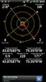
Very technical interface. I love it.
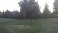
Towards 'home run territory.'
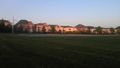
No night game tonight.

Grin? Check.


Achievements
Nothing new.