Difference between revisions of "2012-06-03 51 -1"
From Geohashing
imported>Jand |
imported>FippeBot m (Location) |
||
| (12 intermediate revisions by 3 users not shown) | |||
| Line 2: | Line 2: | ||
| lat=51 | | lat=51 | ||
| lon=-1 | | lon=-1 | ||
| − | | date=2012- | + | | date=2012-06-03 |
}} | }} | ||
| − | + | == Location == | |
| − | + | The hash was located well into MoD red flagged land. | |
| − | + | == Participants == | |
| − | |||
| + | * [[User:Jand|Jand]] | ||
| − | + | == Expedition == | |
| + | Knowing the area fairly well, as the road near the hash was my route to work for a while earlier in the year, I knew the hash would be in restricted area, but hey, a consolation prize is still a prize, so I set off after work to Lopcombe Corner, a fork in the road and the point nearest to the hash that it was safe to get to. Pictures taken, I headed home. | ||
| − | + | However, today is by no means a loss, as I have made contact with two of my fellow geohashers, [[User:Sermoa|Sermoa]] and [[User:Macronencer|Macronencer]], through the magical medium of twitter, so it looks like my lonely geohashing days are over :P . | |
| + | |||
| + | Quite a good day all round. | ||
| + | |||
| + | == Gallery == | ||
| + | |||
| + | <gallery perrow="2"> | ||
| + | Image:2012-06-03 51 -1 me.jpg|Me at the alternate meeting point. | ||
| + | Image:2012-06-03 51 -1 warning signs.jpg| Probably not a good idea to complete this one.... | ||
| + | </gallery> | ||
| + | |||
| + | == Achievements == | ||
| + | |||
| + | {{No trespassing | ||
| + | | latitude = 51| longitude = -1 | date = 2012-06-03 | name = Jand | | ||
| + | }} | ||
| + | |||
| + | [[Category:Expeditions]] | ||
| + | [[Category:Expeditions with photos]] | ||
| + | [[Category:Coordinates not reached]] | ||
| + | [[Category:Not reached - No public access]] | ||
| + | {{location|GB|ENG|WIL}} | ||
Latest revision as of 04:22, 13 August 2019
| Sun 3 Jun 2012 in 51,-1: 51.1220486, -1.6763580 geohashing.info google osm bing/os kml crox |
Location
The hash was located well into MoD red flagged land.
Participants
Expedition
Knowing the area fairly well, as the road near the hash was my route to work for a while earlier in the year, I knew the hash would be in restricted area, but hey, a consolation prize is still a prize, so I set off after work to Lopcombe Corner, a fork in the road and the point nearest to the hash that it was safe to get to. Pictures taken, I headed home.
However, today is by no means a loss, as I have made contact with two of my fellow geohashers, Sermoa and Macronencer, through the magical medium of twitter, so it looks like my lonely geohashing days are over :P .
Quite a good day all round.
Gallery

Me at the alternate meeting point.
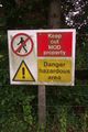
Probably not a good idea to complete this one....


Achievements
Jand earned the No trespassing consolation prize
|