Difference between revisions of "2012-06-16 -38 145"
imported>Felix Dance (Created page with "{{meetup graticule | lat=-38 | lon=145 | date=2012-06-16 }} == Location == On a street corner in Cranbourne == Who is going == * Felix Dance ==Expedition=...") |
m (More specific location) |
||
| (3 intermediate revisions by 2 users not shown) | |||
| Line 6: | Line 6: | ||
== Location == | == Location == | ||
| − | On a street corner in Cranbourne | + | On a street corner in Cranbourne, SE of Melbourne |
== Who is going == | == Who is going == | ||
| Line 13: | Line 13: | ||
==Expedition== | ==Expedition== | ||
=== [[User:Felix Dance|Felix Dance]] === | === [[User:Felix Dance|Felix Dance]] === | ||
| − | I | + | I discovered this one at 11:30pm the previous night after coming back from the usual Inverloch pub scene and immediately threw my hat in for it. The next morning, scrutinising the weekend's geohashes with greater clarity of thought, I discovered, much to my amazement, that all three would be easily achievable for the two eastern Melbourne graticules. |
| − | + | Sure, enough, after leaving work at around 1pm, I drove the Cranbourne way back to Melbourne (rather than my usual Pakenham way, there's not much in it), took a left, then a right, then another right, parked, got out, and blam! There I was at the hash, right on the corner in the front yard of a house. After taking photos and what-not, I took a hash-piss in a nearby park (carefully avoiding any wandering pedestrians), got back in the car and drove home. What a non-event! | |
| − | + | [http://goo.gl/maps/2Igw Here] is the Google Maps route I took. | |
| + | Hash reached: 2:20pm | ||
| + | |||
| + | See [[2012-06-17 -37 145]] for the next day's hash. | ||
== Photos == | == Photos == | ||
<gallery perrow="4"> | <gallery perrow="4"> | ||
| + | Image:Geohash 2012 06 16 -38 145 Corner.JPG|Hash-Street-Corner | ||
| + | Image:Geohash 2012 06 16 -38 145 Felix.JPG|Felix at the hash | ||
| + | Image:Geohash 2012 06 16 -38 145 GPS.JPG|GPS Proof | ||
| + | </gallery> | ||
| − | + | == Achievement == | |
| + | {{consecutive geohash | ||
| + | |||
| + | | count = 3 | ||
| + | | latitude = -38 | ||
| + | | longitude = 145 | ||
| + | | date = 2012-06-16 | ||
| + | | name = [[User:Felix Dance|Felix Dance]] | ||
| + | |||
| + | }} | ||
[[Category:Expeditions]] | [[Category:Expeditions]] | ||
[[Category:Coordinates reached]] | [[Category:Coordinates reached]] | ||
[[Category:Expeditions with photos]] | [[Category:Expeditions with photos]] | ||
| − | + | {{location|AU|VIC|CS}} | |
Latest revision as of 12:17, 1 August 2020
| Sat 16 Jun 2012 in -38,145: -38.1083576, 145.2657730 geohashing.info google osm bing/os kml crox |
Location
On a street corner in Cranbourne, SE of Melbourne
Who is going
Expedition
Felix Dance
I discovered this one at 11:30pm the previous night after coming back from the usual Inverloch pub scene and immediately threw my hat in for it. The next morning, scrutinising the weekend's geohashes with greater clarity of thought, I discovered, much to my amazement, that all three would be easily achievable for the two eastern Melbourne graticules.
Sure, enough, after leaving work at around 1pm, I drove the Cranbourne way back to Melbourne (rather than my usual Pakenham way, there's not much in it), took a left, then a right, then another right, parked, got out, and blam! There I was at the hash, right on the corner in the front yard of a house. After taking photos and what-not, I took a hash-piss in a nearby park (carefully avoiding any wandering pedestrians), got back in the car and drove home. What a non-event!
Here is the Google Maps route I took.
Hash reached: 2:20pm
See 2012-06-17 -37 145 for the next day's hash.
Photos
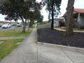
Hash-Street-Corner
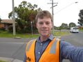
Felix at the hash
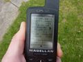
GPS Proof


Achievement
Felix Dance earned the Consecutive geohash achievement
|