Difference between revisions of "2012-07-04 48 9"
imported>Ekorren (been there. Do I have to write a report?) |
m (Location correction) |
||
| (2 intermediate revisions by 2 users not shown) | |||
| Line 14: | Line 14: | ||
== Expedition == | == Expedition == | ||
| + | I'm writing this almost two years later. I can't remember much, really. | ||
| + | I went by bike, through Bebenhausen, and further up. Near the location I must have had a few problems with finding access to this piece of forest. There was a fence to the main road, and a lack of viable areas near the hashpoint, so I circled it and tried various gates (the fence and the gates don't mark any kind of "no trespassing" area but are to keep large game in the forest) and routes, and somehow I must have reached the point in the end. Went back home including a detour via Entringen. | ||
== Gallery == | == Gallery == | ||
<gallery> | <gallery> | ||
| + | File:2012-07-04_48_9_01_bebenhausen.JPG|Impressions from Bebenhausen | ||
| + | File:2012-07-04_48_9_02_bebenhausen.JPG| | ||
| + | File:2012-07-04_48_9_03_bebenhausen.JPG| | ||
| + | File:2012-07-04_48_9_04_bebenhausen.JPG| | ||
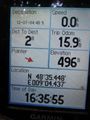
| + | File:2012-07-04_48_9_05_228m_firsttry_gps.JPG|First try ends here. | ||
| + | File:2012-07-04_48_9_06_gps.JPG|Successful try | ||
| + | File:2012-07-04_48_9_07_hashpoint.JPG|The hashpoint, I guess | ||
| + | File:2012-07-04_48_9_08_hashpoint.JPG| | ||
| + | File:2012-07-04_48_9_08_horizontal_tree.JPG|Trees are just sticks of wood. Like matches, you know. | ||
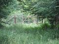
| + | File:2012-07-04_48_9_09_gate.JPG| | ||
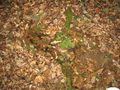
| + | File:2012-07-04_48_9_10_garbage.JPG|Olympia Stuttgart 2012? Ten years earlier, this was a dream of some local politicians. Luckily, the <s>dream</s> nightmare didn't come true. | ||
| + | File:2012-07-04_48_9_11_fence.JPG|Don't be afraid, little stag. Those weird two-legs are all safely behind fences. | ||
</gallery> | </gallery> | ||
| Line 23: | Line 37: | ||
[[Category:Expeditions with photos]] | [[Category:Expeditions with photos]] | ||
[[Category:Coordinates reached]] | [[Category:Coordinates reached]] | ||
| + | {{location|DE|BW|TÜ}} | ||
Latest revision as of 20:15, 16 May 2020
| Wed 4 Jul 2012 in 48,9: 48.5908082, 9.0739284 geohashing.info google osm bing/os kml crox |
Contents
Location
The Schönbuch forest near Dettenhausen, although the point itself still belongs to Tübingen.
Participants
Ekorren went there
Expedition
I'm writing this almost two years later. I can't remember much, really.
I went by bike, through Bebenhausen, and further up. Near the location I must have had a few problems with finding access to this piece of forest. There was a fence to the main road, and a lack of viable areas near the hashpoint, so I circled it and tried various gates (the fence and the gates don't mark any kind of "no trespassing" area but are to keep large game in the forest) and routes, and somehow I must have reached the point in the end. Went back home including a detour via Entringen.
Gallery
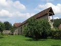
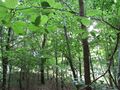
Impressions from Bebenhausen


First try ends here.
Successful try
The hashpoint, I guess

Trees are just sticks of wood. Like matches, you know.
Olympia Stuttgart 2012? Ten years earlier, this was a dream of some local politicians. Luckily, the
dreamnightmare didn't come true.
Don't be afraid, little stag. Those weird two-legs are all safely behind fences.


