Difference between revisions of "2012-08-23 -37 143"
imported>Snaplatitude (An expedition message sent via Geohash Droid for Android.) |
m (More specific location) |
||
| (21 intermediate revisions by 4 users not shown) | |||
| Line 1: | Line 1: | ||
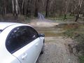
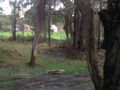
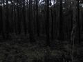
| + | [[IMAGE:2012-08-23_-37_143_22-27-16-825.jpg|thumb|left|400px|Too spooky!]] | ||
| − | |||
| − | |||
| − | |||
| − | |||
| − | |||
| − | |||
| − | |||
| − | |||
| − | |||
{{meetup graticule | {{meetup graticule | ||
| lat=-37 | | lat=-37 | ||
| Line 15: | Line 7: | ||
}} | }} | ||
| − | |||
| − | |||
== Location == | == Location == | ||
| − | + | Cabbage Tree, south of Creswick. | |
== Participants == | == Participants == | ||
| − | + | *[[User:Snaplatitude|Snaplatitude]] | |
| − | |||
== Plans == | == Plans == | ||
| − | + | I have been a geohasher for almost six months now and due to living in a graticule primarily covered in farmland and private paddocks I have only been able to complete one geohash so far. So you can imagine my excitement when I found todays hash was inside a local state park, Creswick park, a large eucalyptus bushland. Coincidentally we had visited this area just two days ago on a random outing. I was determined to head out and claim this geohash, finally a second one! | |
== Expedition == | == Expedition == | ||
| − | + | Well. Firstly I had the day off today and I spent it with two close friends, but in the afternoon when I was ready and excited to go geohashing both of them had to go off to work or university, so I was left on my own. This solitude did not deter me. Neither did the rain and hail-storms we had earlier today. | |
| + | |||
| + | I entered from the worst direction in hindsight. Coming from the West I entered a labrynth of dirt tracks and roads full of potholes when if I had come from the East I would have been straignt at the destination with hardly any hassles. | ||
| + | |||
| + | [[IMAGE:2012-08-23_-37_143_map.jpg|centre|900px|like a maze!]] | ||
| + | |||
| + | In the beginnning it was a quite relaxing trip, despite the potholes. I saw many of Australia's native fauna including rare yelllow-tailed black cockatoos. So I pottered around the labrynth of roads and tracks until I was getting close at Slatey Creek, but due to the hail-storm earlier in the day the creek was flooding over the road. I stared at the raging torrent for some time thinking about just speeding the car through it... | ||
| + | |||
| + | [[IMAGE:2012-08-23_-37_143_19-54-15-176.jpg|thumb|Right|500px|Never drive through floodwaters]] | ||
| + | |||
| + | I might've been able to make it, but what if there was a worse barrier further ahead? I might be able to cross this flooding creek once, but twice definitely not. So I could have turned back and given up, but instead I found another way, turned the car around and headed up north via Cabbage Tree, and around and through the forest again. As the sun was setting and dusk was sneaking through the trees I recalled the constant TV ads about not driving, swimming or playing in flood-waters and decided I'd made the right decision. | ||
| + | |||
| + | When I finally arrived at my destination the sun had all but set, the bush was dark and forboding, but I was determined to get this hash! I want so bad to complete another one! So I stumble out of the car into the bush, my 10" android tablet in one hand, the other hand out in front of me to save me if I trip. It was only a 500 metre walk to the hash, but I didn't make it. After about 200 metres, when I had lost sight of the car, I remembered all the warnings I had been given about abandoned unmarked mineshafts in this area. I remembered the two or three people every year who get lost in this forest. I remembered I hadn't told anybody I was going geohashing so they wuoldn't know where to start looking. And I remembered how much it hurt that time I got attacked by kangaroos and they scratched open my belly. I had to turn back. I am a reasonable, rational being, and I just couldn't put myself in this much of a risky situation. | ||
| + | |||
| + | Next time I need to set of earlier so I arrive at the hashpoint during daylight. | ||
| − | + | Until then, I think I have earned the Pize Poultry consolation prize for chickening out despite my determination. | |
| − | |||
== Photos == | == Photos == | ||
| Line 38: | Line 40: | ||
--> | --> | ||
<gallery perrow="5"> | <gallery perrow="5"> | ||
| + | |||
| + | Image:2012-08-23_-37_143_19-54-15-176.jpg | | ||
| + | |||
| + | Image:2012-08-23_-37_143_22-18-27-757.jpg | Yellow tailed black cockatoos | ||
| + | |||
| + | Image:2012-08-23_-37_143_22-19-07-327.jpg | Magpie | ||
| + | |||
| + | Image:2012-08-23_-37_143_22-19-40-924.jpg | | ||
| + | |||
| + | Image:2012-08-23_-37_143_22-23-58-821.jpg | Wood ducks | ||
| + | |||
| + | Image:2012-08-23_-37_143_22-25-11-931.jpg | House with a whole roof of solar panels | ||
| + | |||
| + | Image:2012-08-23_-37_143_22-25-50-877.jpg | | ||
| + | |||
| + | Image:2012-08-23_-37_143_22-26-27-425.jpg | | ||
| + | |||
| + | Image:2012-08-23_-37_143_22-26-50-303.jpg | Bah! | ||
| + | |||
| + | Image:2012-08-23_-37_143_22-27-16-825.jpg | | ||
</gallery> | </gallery> | ||
== Achievements == | == Achievements == | ||
{{#vardefine:ribbonwidth|800px}} | {{#vardefine:ribbonwidth|800px}} | ||
| − | + | {{Prize poultry|latitude=-37|longitude=143|date = 2012-08-23|name = [[User:Snaplatitude|Snaplatitude]]|reason = it was dark, scary and dangerous.}} | |
| − | |||
| − | |||
| − | |||
| − | |||
| − | |||
| − | |||
| − | |||
| − | |||
| − | |||
| − | |||
| − | |||
[[Category:Expeditions]] | [[Category:Expeditions]] | ||
| − | |||
[[Category:Expeditions with photos]] | [[Category:Expeditions with photos]] | ||
| − | |||
| − | |||
| − | |||
| − | |||
| − | |||
| − | |||
| − | |||
| − | |||
| − | |||
[[Category:Coordinates not reached]] | [[Category:Coordinates not reached]] | ||
| − | |||
| − | |||
[[Category:Not reached - Mother Nature]] | [[Category:Not reached - Mother Nature]] | ||
| − | + | {{location|AU|VIC|HE}} | |
| − | |||
| − | |||
| − | |||
| − | |||
| − | |||
| − | |||
| − | |||
| − | |||
| − | |||
| − | |||
Latest revision as of 12:20, 1 August 2020

| Thu 23 Aug 2012 in -37,143: -37.4596090, 143.9264741 geohashing.info google osm bing/os kml crox |
Location
Cabbage Tree, south of Creswick.
Participants
Plans
I have been a geohasher for almost six months now and due to living in a graticule primarily covered in farmland and private paddocks I have only been able to complete one geohash so far. So you can imagine my excitement when I found todays hash was inside a local state park, Creswick park, a large eucalyptus bushland. Coincidentally we had visited this area just two days ago on a random outing. I was determined to head out and claim this geohash, finally a second one!
Expedition
Well. Firstly I had the day off today and I spent it with two close friends, but in the afternoon when I was ready and excited to go geohashing both of them had to go off to work or university, so I was left on my own. This solitude did not deter me. Neither did the rain and hail-storms we had earlier today.
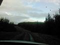
I entered from the worst direction in hindsight. Coming from the West I entered a labrynth of dirt tracks and roads full of potholes when if I had come from the East I would have been straignt at the destination with hardly any hassles.

In the beginnning it was a quite relaxing trip, despite the potholes. I saw many of Australia's native fauna including rare yelllow-tailed black cockatoos. So I pottered around the labrynth of roads and tracks until I was getting close at Slatey Creek, but due to the hail-storm earlier in the day the creek was flooding over the road. I stared at the raging torrent for some time thinking about just speeding the car through it...

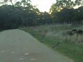
I might've been able to make it, but what if there was a worse barrier further ahead? I might be able to cross this flooding creek once, but twice definitely not. So I could have turned back and given up, but instead I found another way, turned the car around and headed up north via Cabbage Tree, and around and through the forest again. As the sun was setting and dusk was sneaking through the trees I recalled the constant TV ads about not driving, swimming or playing in flood-waters and decided I'd made the right decision.
When I finally arrived at my destination the sun had all but set, the bush was dark and forboding, but I was determined to get this hash! I want so bad to complete another one! So I stumble out of the car into the bush, my 10" android tablet in one hand, the other hand out in front of me to save me if I trip. It was only a 500 metre walk to the hash, but I didn't make it. After about 200 metres, when I had lost sight of the car, I remembered all the warnings I had been given about abandoned unmarked mineshafts in this area. I remembered the two or three people every year who get lost in this forest. I remembered I hadn't told anybody I was going geohashing so they wuoldn't know where to start looking. And I remembered how much it hurt that time I got attacked by kangaroos and they scratched open my belly. I had to turn back. I am a reasonable, rational being, and I just couldn't put myself in this much of a risky situation.
Next time I need to set of earlier so I arrive at the hashpoint during daylight.
Until then, I think I have earned the Pize Poultry consolation prize for chickening out despite my determination.
Photos
Yellow tailed black cockatoos

Magpie
Wood ducks
House with a whole roof of solar panels
Bah!


Achievements
Snaplatitude earned the Prize poultry Consolation Prize
|