Difference between revisions of "2012-08-26 46 11"
imported>Werther (Created page with "{{subst:Expedition |lat = 46 |lon = 11 |date = 2012-08-26 }}") |
m (Location correction) |
||
| (2 intermediate revisions by 2 users not shown) | |||
| Line 1: | Line 1: | ||
| − | |||
<!-- If you did not specify these parameters in the template, please substitute appropriate values for IMAGE, LAT, LON, and DATE (YYYY-MM-DD format) | <!-- If you did not specify these parameters in the template, please substitute appropriate values for IMAGE, LAT, LON, and DATE (YYYY-MM-DD format) | ||
| Line 18: | Line 17: | ||
__NOTOC__ | __NOTOC__ | ||
== Location == | == Location == | ||
| − | + | A porphiry quarry near Gazzadina, Trento. | |
== Participants == | == Participants == | ||
| − | + | [[User:Werther|Werther]] | |
| − | |||
== Plans == | == Plans == | ||
| − | + | I didn't mean to go today, partly because I had a family reunion with massive lunch but mainly because it had been raining all morning. But since it was reachable and it turned out to be a very pretty day in the afternoon, I checked the bus timetables and decided I'd give it a try. Also, the GPS was working properly today! | |
== Expedition == | == Expedition == | ||
| − | + | I left home around 5.30 pm. Despite being relatively a long way from downtown Trento, the area around the hash was still served by the city bus service rather than the intercity network. | |
| + | |||
| + | I took bus number 3 to Gazzadina, the closest bus stop. That's where the fun began- differently from my other two expeditions, I had never been in this area before. Also Google Maps showed that the hash was in the middle of a construction area, and I really had no clue about what was being built there. | ||
| + | |||
| + | I followed a major road- labelled as SP76- until a rotary, where a country road branched off. I was stunned by the scenery- the lights and the shadows on the apple fields were simply beautiful. As I was walking I realized I was getting more and more into the shadow, and that a cold wind had started to blow. | ||
| + | |||
| + | It took me approximately 30 minutes to discover that all the trucks and the excavator were still at their place- it wasn't a construction site, but a porphyre quarry. No one was around except for a guy jogging and another guy walking his dog, and there weren't any no trespassing signs. I had no problems in getting close to the hashpoint- but then, I realized that it was a few meters down a very steep hillside. | ||
| − | + | I was late on my timetable and couldn't afford to spend time to get to the exact point, so I just took a photo of the hash area from the roadside. Last but not least, I also had to run in order not to miss the bus back. Even though I only got to see the hashpoint, I wouldn't call this a defeat. I got there after all, and more importantly discovered a very nice place I had never seen despite living here since my birth. It was a very nice way to spend a Sunday afternoon. | |
| − | |||
== Photos == | == Photos == | ||
| − | <! | + | <gallery> |
| − | Image: | + | Image:20120826 Trento 001.JPG|The timetable from the bus stop in Trento |
| − | + | Image:20120826 Trento 002.JPG|Got off the bus in Gazzadina. Nice scenery | |
| − | + | Image:20120826 Trento 003.JPG|The country road (left) branches off the main road to Albiano (right) | |
| + | Image:20120826 Trento 004.JPG|Due to the hills nearby hiding the sunlight, the road gets into the dark... | ||
| + | Image:20120826 Trento 005.JPG|Again difference between light and shadow, amazing. | ||
| + | Image:20120826 Trento 006.JPG|Road signs for hikers. I'm almost there! | ||
| + | Image:20120826 Trento 007.JPG|The steep hillside, hash is somewhere on the left. | ||
| + | Image:20120826 Trento 008.JPG|Stupid grin time! The wind was wery strong at that moment. | ||
| + | Image:20120826 Trento 009.JPG|Proof I was close enough to see the hashpoint | ||
| + | Image:20120826 Trento 010.JPG|The quarry | ||
| + | Image:20120826 Trento 011.JPG|The quarry, again | ||
| + | Image:20120826 Trento 012.JPG|Porphiry cubes | ||
| + | Image:20120826 Trento 013.JPG|When I got back to the bus stop, the sun had just set. | ||
| + | Image:20120826 Trento 014.JPG|There comes the bus home, it's been a great day! | ||
</gallery> | </gallery> | ||
== Achievements == | == Achievements == | ||
| − | + | So, since I was finally able to bring a GPS for proof, I'd claim two achievements: Land geohash and Public transport geohash. | |
| − | + | I didn't really get whether I need anything more to prove my achievements, and whether I can just post ribbons on here and on my userpage or I have to wait for someone to "approve" my accomplishments. | |
| − | + | Clarifications on this are warmly welcome, in the discussion section of this page or my own discussion page. Thank you! | |
| − | |||
| − | |||
| − | |||
| − | |||
| − | |||
| − | |||
| − | |||
| − | |||
| − | |||
| − | |||
[[Category:Expeditions]] | [[Category:Expeditions]] | ||
| − | + | [[Category:Expeditions with photos]] | |
| − | [[Category:Expeditions with photos]] | ||
| − | |||
| − | |||
| − | |||
| − | |||
| − | |||
[[Category:Coordinates reached]] | [[Category:Coordinates reached]] | ||
| − | + | {{location|IT|TT}} | |
| − | |||
| − | |||
| − | |||
| − | |||
| − | |||
| − | |||
| − | |||
| − | |||
| − | |||
| − | |||
| − | |||
| − | |||
| − | |||
| − | |||
| − | |||
| − | |||
| − | |||
Latest revision as of 15:06, 28 July 2021
| Sun 26 Aug 2012 in 46,11: 46.1457475, 11.1297215 geohashing.info google osm bing/os kml crox |
Location
A porphiry quarry near Gazzadina, Trento.
Participants
Plans
I didn't mean to go today, partly because I had a family reunion with massive lunch but mainly because it had been raining all morning. But since it was reachable and it turned out to be a very pretty day in the afternoon, I checked the bus timetables and decided I'd give it a try. Also, the GPS was working properly today!
Expedition
I left home around 5.30 pm. Despite being relatively a long way from downtown Trento, the area around the hash was still served by the city bus service rather than the intercity network.
I took bus number 3 to Gazzadina, the closest bus stop. That's where the fun began- differently from my other two expeditions, I had never been in this area before. Also Google Maps showed that the hash was in the middle of a construction area, and I really had no clue about what was being built there.
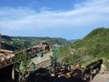
I followed a major road- labelled as SP76- until a rotary, where a country road branched off. I was stunned by the scenery- the lights and the shadows on the apple fields were simply beautiful. As I was walking I realized I was getting more and more into the shadow, and that a cold wind had started to blow.
It took me approximately 30 minutes to discover that all the trucks and the excavator were still at their place- it wasn't a construction site, but a porphyre quarry. No one was around except for a guy jogging and another guy walking his dog, and there weren't any no trespassing signs. I had no problems in getting close to the hashpoint- but then, I realized that it was a few meters down a very steep hillside.
I was late on my timetable and couldn't afford to spend time to get to the exact point, so I just took a photo of the hash area from the roadside. Last but not least, I also had to run in order not to miss the bus back. Even though I only got to see the hashpoint, I wouldn't call this a defeat. I got there after all, and more importantly discovered a very nice place I had never seen despite living here since my birth. It was a very nice way to spend a Sunday afternoon.
Photos
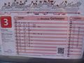
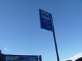
The timetable from the bus stop in Trento
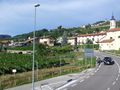
Got off the bus in Gazzadina. Nice scenery
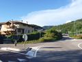
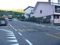
The country road (left) branches off the main road to Albiano (right)
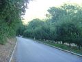
Due to the hills nearby hiding the sunlight, the road gets into the dark...
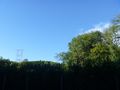
Again difference between light and shadow, amazing.
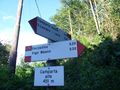
Road signs for hikers. I'm almost there!
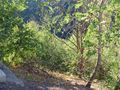
The steep hillside, hash is somewhere on the left.

Stupid grin time! The wind was wery strong at that moment.
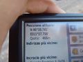
Proof I was close enough to see the hashpoint
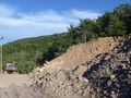
The quarry
The quarry, again
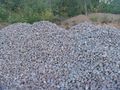
Porphiry cubes
When I got back to the bus stop, the sun had just set.
There comes the bus home, it's been a great day!


Achievements
So, since I was finally able to bring a GPS for proof, I'd claim two achievements: Land geohash and Public transport geohash. I didn't really get whether I need anything more to prove my achievements, and whether I can just post ribbons on here and on my userpage or I have to wait for someone to "approve" my accomplishments. Clarifications on this are warmly welcome, in the discussion section of this page or my own discussion page. Thank you!