Difference between revisions of "2012-08-31 -37 143"
From Geohashing
imported>Snaplatitude ([live picture] [http://www.openstreetmap.org/?lat=-37.56579550&lon=143.87040840&zoom=16&layers=B000FTF @-37.5658,143.8704]) |
m (More specific location) |
||
| (10 intermediate revisions by 5 users not shown) | |||
| Line 1: | Line 1: | ||
| − | + | [[IMAGE:2012-08-31_-37_143_17-24-08-796.jpg|thumb|left]] | |
| − | |||
| − | |||
| − | |||
| − | |||
| − | |||
| − | |||
| − | |||
| − | |||
| − | |||
{{meetup graticule | {{meetup graticule | ||
| lat=-37 | | lat=-37 | ||
| Line 18: | Line 9: | ||
__NOTOC__ | __NOTOC__ | ||
== Location == | == Location == | ||
| − | + | A service road just off Victoria Street in Ballarat. Right near Hungry Jack's. | |
== Participants == | == Participants == | ||
| − | + | * [[User:Snaplatitude|Snaplatitude]] | |
| − | + | * A lady friend | |
== Plans == | == Plans == | ||
| − | + | We noticed the geohash today was at (well, just opposite) Hungry Jack's in town, so we thought we'd give it a go after work at about 5.30PM. | |
== Expedition == | == Expedition == | ||
| − | + | Planned to meet at 5.30 at the hash, I took the lady in the quarter-of-a-century-old car and we'd agreed to meet a fellow hasher there, but he bailed via text when we arrived. | |
| − | + | First time I've ever had a hash in town, we didn't even have to leave the car (although the lady DID go to grab some HJ's for me. =)) | |
| − | |||
| − | |||
== Photos == | == Photos == | ||
| Line 39: | Line 28: | ||
<gallery perrow="5"> | <gallery perrow="5"> | ||
| − | Image:2012-08-31_-37_143_17-22-33-585.jpg | | + | Image:2012-08-31_-37_143_17-22-33-585.jpg | |
| + | |||
| + | Image:2012-08-31_-37_143_17-24-08-796.jpg | | ||
| + | |||
| + | Image:2012-08-31_-37_143_17-37-23-721.jpg | Two [[:Category:Grins|Stupid Grins™]] | ||
</gallery> | </gallery> | ||
| Line 46: | Line 39: | ||
<!-- Add any achievement ribbons you earned below, or remove this section --> | <!-- Add any achievement ribbons you earned below, or remove this section --> | ||
| − | |||
| − | |||
| − | |||
| − | |||
| − | |||
| − | |||
| − | |||
| − | |||
| − | |||
| − | |||
| − | |||
[[Category:Expeditions]] | [[Category:Expeditions]] | ||
| − | |||
[[Category:Expeditions with photos]] | [[Category:Expeditions with photos]] | ||
| − | |||
| − | |||
| − | |||
| − | |||
| − | |||
[[Category:Coordinates reached]] | [[Category:Coordinates reached]] | ||
| − | + | {{location|AU|VIC|BA}} | |
| − | |||
| − | |||
| − | |||
| − | |||
| − | |||
| − | |||
| − | |||
| − | |||
| − | |||
| − | |||
| − | |||
| − | |||
| − | |||
| − | |||
| − | |||
| − | |||
| − | |||
Latest revision as of 12:22, 1 August 2020

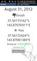
| Fri 31 Aug 2012 in -37,143: -37.5617316, 143.8707691 geohashing.info google osm bing/os kml crox |
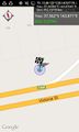
Location
A service road just off Victoria Street in Ballarat. Right near Hungry Jack's.
Participants
- Snaplatitude
- A lady friend
Plans
We noticed the geohash today was at (well, just opposite) Hungry Jack's in town, so we thought we'd give it a go after work at about 5.30PM.
Expedition
Planned to meet at 5.30 at the hash, I took the lady in the quarter-of-a-century-old car and we'd agreed to meet a fellow hasher there, but he bailed via text when we arrived. First time I've ever had a hash in town, we didn't even have to leave the car (although the lady DID go to grab some HJ's for me. =))
Photos

Two Stupid Grins™

